File:Wawa_footprint_2012-07.png
From Wikipedia, the free encyclopedia
Величина овог приказа: 548 × 599 пиксела. 3 друге резолуције: 220 × 240 пиксела | 439 × 480 пиксела | 644 × 704 пиксела.
Оригинална датотека (644 × 704 пиксела, величина датотеке: 138 kB, MIME тип: image/png)
| Ово је датотека са Викимедијине оставе. Информације са њене странице са описом приказане су испод. Викимедијина остава је складиште слободно лиценциралних мултимедијалних датотека. И Ви можете да помогнете. |
Опис


| Point Maps
══▻ FAQ ◅══ ══▻ Create your own ◅══ |
Лиценцирање
Ова датотека је доступна под лиценцом Creative Commons Ауторство-Делити под истим условима 3.0 Unported.
- Дозвољено је:
- да делите – да умножавате, расподељујете и преносите дело
- да прерађујете – да прерадите дело
- Под следећим условима:
- ауторство – Морате да дате одговарајуће заслуге, обезбедите везу ка лиценци и назначите да ли су измене направљене. Можете то урадити на било који разуман манир, али не на начин који предлаже да лиценцатор одобрава вас или ваше коришћење.
- делити под истим условима – Ако измените, преобразите или доградите овај материјал, морате поделити своје доприносе под истом или компатибилном лиценцом као оригинал.
Првобитан дневник отпремања
This image is a derivative work of the following images:
- File:USA_Pennsylvania_location_map.svg licensed with Cc-by-3.0, GFDL
- 2009-07-05T11:11:22Z Alexrk2 1201x805 (429769 Bytes) == Beschreibung == {{Information |Description= {{de|Positionskarte von [[:de:Pennsylvania|Pennsylvania]], [[:de:USA|USA]]}} Quadratische Plattkarte, N-S-Streckung 130.0 %. Geographische Begrenzung der Karte: * N: 42.7° N * S
- File:USA_New_Jersey_location_map.svg licensed with Cc-by-3.0, GFDL
- 2009-06-17T19:59:27Z Alexrk2 839x1560 (259806 Bytes) enh
- 2009-06-13T18:01:16Z Alexrk 839x1560 (198653 Bytes) fixed SVG bug
- 2009-06-13T17:46:17Z Alexrk 839x1560 (246056 Bytes) == Beschreibung == {{Information |Description= {{de|Positionskarte von [[:de:New Jersey|New Jersey]], [[:de:USA|USA]]}} Quadratische Plattkarte, N-S-Streckung 130.0 %. Geographische Begrenzung der Karte: * N: 41.6° N * S: 38
- File:USA_Maryland_location_map.svg licensed with Cc-by-3.0, GFDL
- 2009-06-22T11:30:38Z Alexrk2 1200x764 (463352 Bytes) fixed border
- 2009-06-22T11:23:05Z Alexrk2 1200x764 (459278 Bytes) crop height
- 2009-06-22T11:03:54Z Alexrk2 1201x955 (455501 Bytes) renderer bug
- 2009-06-22T10:42:06Z Alexrk2 800x636 (318450 Bytes) == Beschreibung == {{Information |Description= {{de|Positionskarte von [[:de:Maryland|Maryland]], [[:de:USA|USA]]}} Quadratische Plattkarte, N-S-Streckung 130.0 %. Geographische Begrenzung der Karte: * N: 40.3° N * S: 37.3°
- File:USA_New_York_location_map.svg licensed with Cc-by-3.0, GFDL
- 2009-06-10T11:28:20Z NordNordWest 1572x1277 (597043 Bytes) {{Information |Description= {{de|Positionskarte vom Bundesstaat [[:de:New York (Bundesstaat)|New York]], [[:de:USA|USA]]}} Quadratische Plattkarte, N-S-Streckung 135 %. Geographische Begrenzung der Karte: * N: 45.3° N * S: 4
- File:USA_Virginia_location_map.svg licensed with Cc-by-3.0, GFDL
- 2009-07-06T18:02:25Z Alexrk2 1500x964 (963271 Bytes) resize
- 2009-06-26T16:42:40Z Alexrk2 1201x772 (966691 Bytes) == Beschreibung == {{Information |Description= {{de|Positionskarte von [[:de:Virginia|Virginia]], [[:de:USA|USA]]}} Quadratische Plattkarte, N-S-Streckung 130.0 %. Geographische Begrenzung der Karte: * N: 40.2° N * S: 35.8°
- File:USA_West_Virginia_location_map.svg licensed with Cc-by-3.0, GFDL
- 2009-07-03T15:31:49Z Alexrk2 1201x1118 (535137 Bytes) == Beschreibung == {{Information |Description= {{de|Positionskarte von [[:de:West Virginia|West Virginia]], [[:de:USA|USA]]}} Quadratische Plattkarte, N-S-Streckung 130.0 %. Geographische Begrenzung der Karte: * N: 40.8° N *
- File:USA_Florida_location_map.svg licensed with Cc-by-3.0
- 2008-12-15T20:25:08Z Sting 1132x1096 (591820 Bytes) Counties boundaries: thinner strokes
- 2008-12-15T19:49:40Z Sting 1132x1096 (591829 Bytes) == Summary == {{Location|27|45|00|N|83|49|30|W|scale:4000000}} {{Information |Description={{en|Blank administrative map of the State of [[:en:Florida|Florida]], [[:en:United States|USA]], for geo-location purpose, with count
- File:USA_Connecticut_location_map.svg licensed with Cc-by-3.0, GFDL
- 2009-06-25T19:16:48Z Alexrk2 800x678 (154250 Bytes) renderer bug
- 2009-06-25T19:14:39Z Alexrk2 800x678 (155149 Bytes) == Beschreibung == {{Information |Description= {{de|Positionskarte von [[:de:Connecticut|Connecticut]], [[:de:USA|USA]]}} Quadratische Plattkarte, N-S-Streckung 130.0 %. Geographische Begrenzung der Karte: * N: 42.3° N * S:
- File:USA_North_Carolina_location_map.svg licensed with Cc-by-3.0, GFDL
- 2010-04-25T12:44:25Z Alexrk2 1400x849 (1201046 Bytes) enh rivers, aligned state borders
- 2009-06-26T22:06:53Z Alexrk2 1400x849 (894030 Bytes) resize
- 2009-06-26T21:57:18Z Alexrk2 1400x849 (896940 Bytes) resize
- 2009-06-26T21:47:07Z Alexrk2 1201x728 (930560 Bytes) == Beschreibung == {{Information |Description= {{de|Positionskarte von [[:de:North Carolina|North Carolina]], [[:de:USA|USA]]}} Quadratische Plattkarte, N-S-Streckung 120.0 %. Geographische Begrenzung der Karte: * N: 37.5° N
- File:USA_Delaware_location_map.svg licensed with Cc-by-3.0, GFDL
- 2009-06-22T10:54:18Z Alexrk2 470x800 (106507 Bytes) renderer bug
- 2009-06-22T10:39:54Z Alexrk2 470x800 (66078 Bytes) == Beschreibung == {{Information |Description= {{de|Positionskarte von [[:de:Delaware|Delaware]], [[:de:USA|USA]]}} Quadratische Plattkarte, N-S-Streckung 130.0 %. Geographische Begrenzung der Karte: * N: 40.0° N * S: 38.3°
Uploaded with derivativeFX
Натписи
Укратко шта ова датотека представља/приказује
Ставке приказане у овој датотеци
приказује
31. јул 2012
Историја датотеке
Кликните на датум/време да бисте видели тадашњу верзију датотеке.
| Датум/време | Минијатура | Димензије | Корисник | Коментар | |
|---|---|---|---|---|---|
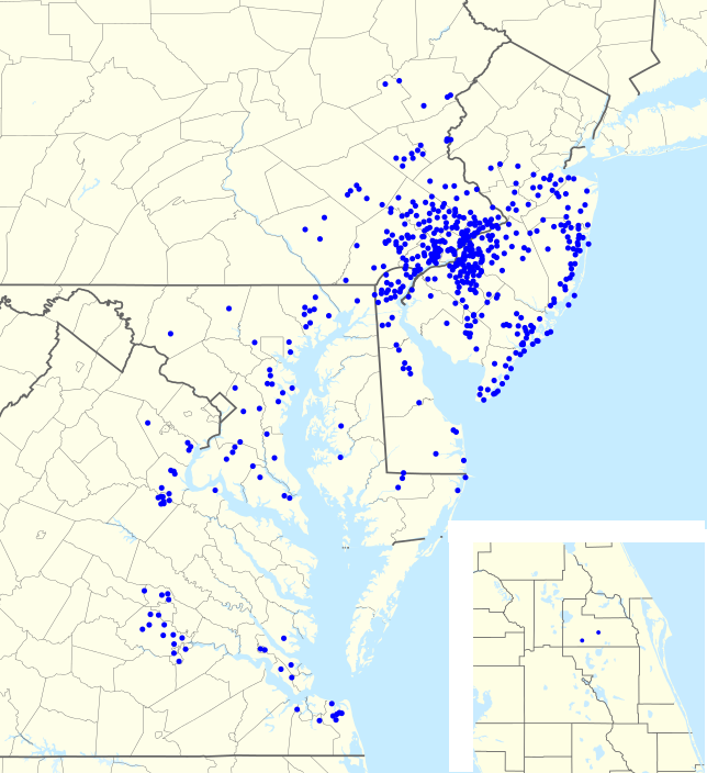
| тренутна | 00:57, 1. август 2012. | | 644 × 704 (138 kB) | Magog the Ogre | == {{int:filedesc}} == {{Information |Description={{en|1=Footprint of en:Wawa Inc. as of {{ISOdate|2011-06-25}}.}} |Source={{Derived from|USA_Pennsylvania_location_map.svg|USA_New_Jersey_location_map.svg|USA_Maryland_location_map.svg|USA_New_York... |
Употреба датотеке
Нема страница које користе ову датотеку.
Метаподаци
Ова датотека садржи додатне податке, који вероватно долазе од дигиталног фотоапарата или скенера коришћеног за дигитализацију.
Ако је првобитно стање датотеке промењено, могуће је да неки детаљи не описују измењену датотеку у потпуности.
| Водоравна резолуција | 35,43 тпц |
|---|---|
| Вертикална резолуција | 35,43 тпц |
| Датум и време последње промене датотеке | 22:42, 31. јул 2012. |