Skeda:Atlas_Van_der_Hagen-_IlIyricvm_Sclavoniam-_Bosnam_Dalmatiam_Slavoniam_Croatiam.jpg
From Wikipedia, the free encyclopedia
Dokument origjinal ((përmasa 5.353 × 4.520 px, madhësia skedës: 8,09 MB, lloji MIME: image/jpeg))
| Kjo skedë është prej Wikimedia Commons dhe mund të përdoret nga projekte të tjera. Përshkrimi në këtë skedë në këtë faqe nuk është treguar më poshtë. | Shko tek faqja përshkruese në Commons |
Përmbledhje
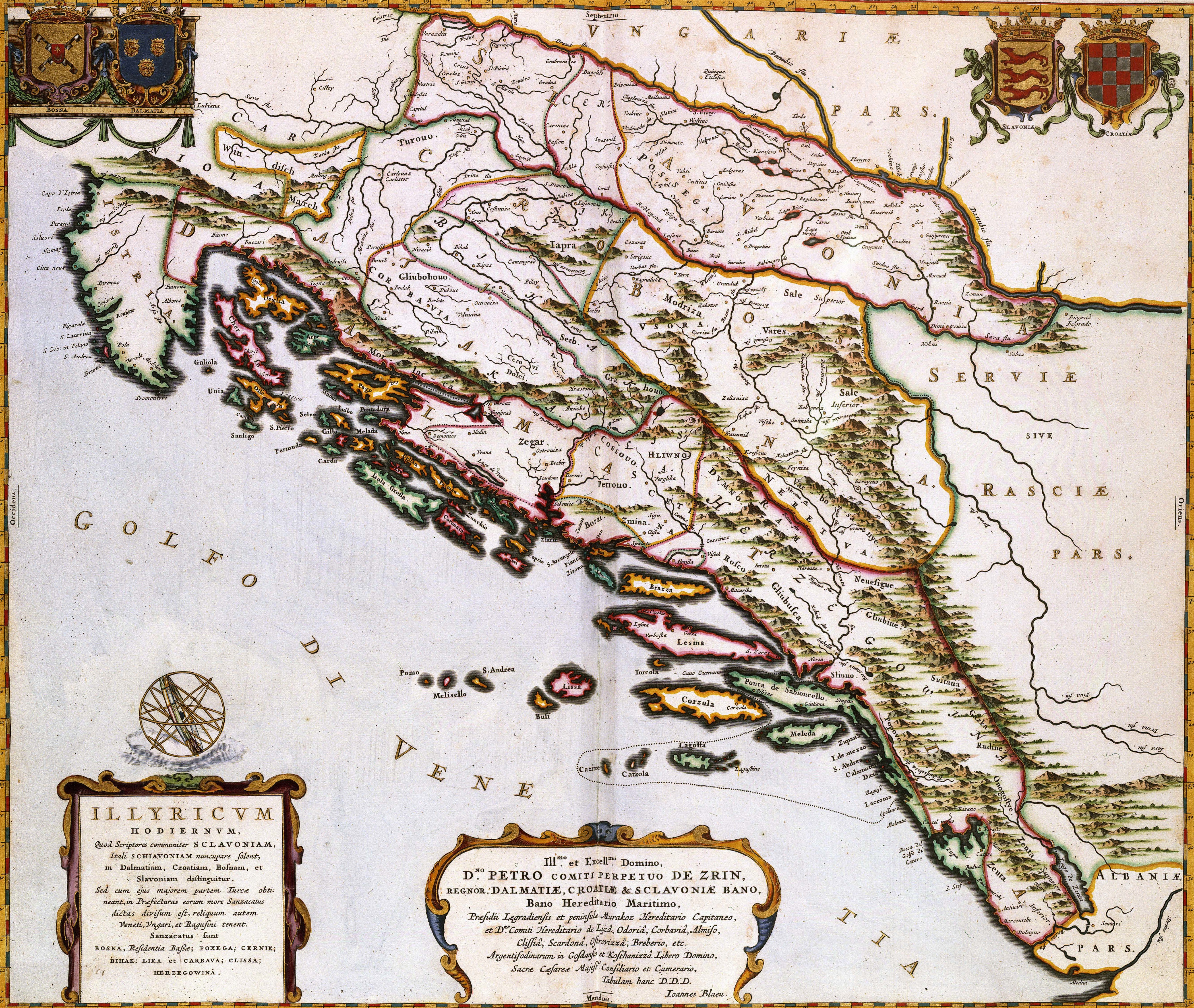
| ILIYRICVM HODIERNVM, Quod Scriptores communiter SCLAVONIAM, Itali SCHIAVONIAM nuncupare solent, in Dalmatiam, Croatiam, Bosnam, et Slavoniam
( |
|||||||||||||||||||||||||||
|---|---|---|---|---|---|---|---|---|---|---|---|---|---|---|---|---|---|---|---|---|---|---|---|---|---|---|---|
| Autori |
Publisher:
creator QS:P170,Q379677 |
||||||||||||||||||||||||||
| Title |
ILIYRICVM HODIERNVM, Quod Scriptores communiter SCLAVONIAM, Itali SCHIAVONIAM nuncupare solent, in Dalmatiam, Croatiam, Bosnam, et Slavoniam |
||||||||||||||||||||||||||
| Object type |
hartë object_type QS:P31,Q4006 |
||||||||||||||||||||||||||
| Përshkrimi |
Nederlands: Deze kaart van de oostkust van de Adriatische Zee werd in 1663 door Joan Blaeu (1598-1673) gepubliceerd in de franse editie van zijn Atlas Maior. Waarschijnlijk kopieerde Blaeu de afbeelding uit een moderne Franse bron, wat niet betekende dat het kaartbeeld daarmee ook actueel was. Door de Turkse bezetting gedurende de 17de eeuw was het gebied nauwelijks toegankelijk waardoor kartografen veelvuldig gebruik maakten van verouderd kaartmateriaal uit de 16de eeuw.; Middenonder een opdracht van Joan Blaeu aan de graaf Perpetuo de Zrin.
English: This map of the eastern coast of the Adriatic Sea was published in 1663 by Joan Blaeu (1598-1673) in the french edition of his Atlas Maior. Blaeu probable copied the image from a contemporary French source, which did not garantee the maps actuality. Because of the Turkish occupation in the 17th century the area was hardly accessible. For that reason cartographers often had to rely on older materials from the 16th century. |
||||||||||||||||||||||||||
| Data |
1663 date QS:P571,+1663-00-00T00:00:00Z/9 |
||||||||||||||||||||||||||
| Medium |
Nederlands: kopergravure
English: copper engraving print |
||||||||||||||||||||||||||
| Dimensions | 44 x 52 cm | ||||||||||||||||||||||||||
| Koleksion |
institution QS:P195,Q1526131 |
||||||||||||||||||||||||||
| Accession number |
Description of the Atlas Van der Hagen in the catalogue of the KB: http://opc4.kb.nl/DB=1/TTL=1/LNG=EN/PPN?PPN=353012750 |
||||||||||||||||||||||||||
| Place of creation | Amsterdam | ||||||||||||||||||||||||||
| Notes | KW1049B12_084 - Volume 1 | ||||||||||||||||||||||||||
| Related persons InfoField | Joan Blaeu - Perpetuo de Zrin, graaf | ||||||||||||||||||||||||||
| Depicted locations InfoField | Adriatic Sea - Croatia - Dalmatia - Bosnia-Hercegovina | ||||||||||||||||||||||||||
| Source/Photographer |
Source page at the Geheugen van Nederland / Memory of the Netherlands website.
|
||||||||||||||||||||||||||
| Leja (Ripërdor këtë skedë) |
|
||||||||||||||||||||||||||
| Versione tjera |
|
||||||||||||||||||||||||||
.jpg)


Captions
Items portrayed in this file
përshkruan
Bosnia (early medieval) anglisht
Reference
Koninklijke Bibliotheek anglisht
digital image anglisht
image/jpeg
checksum anglisht
446fcee0a4dbf1aacae609e57e0c4dbf8af3214d
data size anglisht
8.486.393 Bajti
4.520 pixel
5.353 pixel
Historiku skedës
Shtypni mbi një datë/kohë për ta parë skedën siç ishte atëherë.
| Data/Koha | Miniaturë | Përmasat | Përdoruesi | Koment | |
|---|---|---|---|---|---|
| e tanishme | 23 janar 2022 05:42 | | 5.353 × 4.520 (8,09 MB) | Santasa99 |
Lidhje skedash
Këto faqe lidhen tek kjo skedë:
Përdorimi global i skedës
Kjo skedë përdoret nga Wiki të tjera në vijim:
- Përdorimi në ar.wikipedia.org
- Përdorimi në en.wikipedia.org
- History of Croatia
- History of Bosnia and Herzegovina
- Pannonia
- Slavonia
- Independent State of Croatia
- Zachlumia
- Military Frontier
- Template:History of Croatia
- Croatia in personal union with Hungary
- Croatian affairs in the Kingdom of Yugoslavia
- History of Croatia (1995–present)
- Croatian Military Frontier
- Bosnia vilayet
- History of Croatia before the Croats
- Kingdom of Dalmatia
- Kingdom of Slavonia
- Slavonian Military Frontier
- Red Croatia
- Socialist Republic of Croatia
- Kingdom of Croatia-Slavonia
- Bosnian uprising (1831–1832)
- Template:History of Bosnia and Herzegovina
- Lands of the Crown of Saint Stephen
- Sava Banovina
- Banovina of Croatia
- Croatian War of Independence
- Early history of Bosnia and Herzegovina
- Bosnia and Herzegovina in the Middle Ages
- Socialist Republic of Bosnia and Herzegovina
- Ottoman Bosnia and Herzegovina
- History of Bosnia and Herzegovina (1941–1945)
- Ban of Slavonia
- History of the Jews in Croatia
- Republic of Poljica
- Jewish people of Bosnia and Herzegovina
- Wikipedia:WikiProject Bosnia and Herzegovina/Templates
- Origin hypotheses of the Croats
- History of Zagreb
- Ban of Croatia
- Usora (zemlja)
- Kingdom of Croatia (Habsburg)
- Duchy of Saint Sava
- Austro-Hungarian rule in Bosnia and Herzegovina
- Stanak
- Illyrian kingdom
- Stjepan Vukčić Kosača
- Timeline of the Croat–Bosniak War
- Banate of Bosnia
- Kingdom of Bosnia
Shikoni më shumë përdorim global të kësaj skede.
Metadata
Kjo skedë përmban hollësira të tjera të cilat mund të jenë shtuar nga kamera ose skaneri dixhital që është përdorur për ta krijuar.
Në qoftë se skeda është ndryshuar nga gjendja origjinale, disa hollësira mund të mos pasqyrojnë versionin e tanishëm.
| Orientimi | Normale |
|---|---|
| Madhësia horizontale | 72 dpi |
| Madhësia vertikale | 72 dpi |
| Softueri i përdorur | Adobe Photoshop CS2 Windows |
| Data dhe ora e ndryshimit të skedës | 18 dhjetor 2007 14:18 |
| Hapësira e ngjyrave | e pa kalibruar |
| Gjerësia Image | 5.500 px |
| lartësi Image | 4.657 px |
| Data dhe ora e digjitalizimit | 18 dhjetor 2007 15:18 |
| Data e ndryshimit të fundit të të dhënave | 18 dhjetor 2007 15:18 |