File:Www.wesleyjohnston.com-users-ireland-maps-historical-map1014.gif
From Wikipedia, the free encyclopedia
Nuk ka përmasa më të madhaja.
Www.wesleyjohnston.com-users-ireland-maps-historical-map1014.gif ((përmasa 466 × 582 px, madhësia skedës: 10 KB, lloji MIME: image/gif))
| Kjo skedë është prej Wikimedia Commons dhe mund të përdoret nga projekte të tjera. Përshkrimi në këtë skedë në këtë faqe nuk është treguar më poshtë. | Shko tek faqja përshkruese në Commons |
Përmbledhje
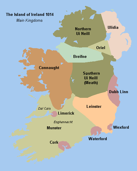
Historical map of Ireland circa 1014 from http://www.wesleyjohnston.com/users/ireland/maps/historical/map1014.gif


 | This image was uploaded as GIF, while a different format would have been more suitable. Commons discourages the use of GIF files, except for animations. See Commons:File types for more information.
If possible, please upload a PNG version (or JPEG for some photos) of this image, and mark the GIF image as {{Superseded|‹new image name›}}. If you like, encourage other Wikimedia projects using the GIF to use the new version instead. If this image is a diagram or other image suitable for vectorisation, please tag this image with {{Convert to SVG}} instead of {{BadGIF}}. If not suitable for vectorisation, use {{Convert to PNG}}. For more information, see {{BadGIF}}. беларуская (тарашкевіца) ∙ català ∙ čeština ∙ Deutsch ∙ English ∙ español ∙ فارسی ∙ suomi ∙ français ∙ עברית ∙ magyar ∙ italiano ∙ 日本語 ∙ македонски ∙ മലയാളം ∙ Plattdüütsch ∙ Nederlands ∙ português ∙ русский ∙ sicilianu ∙ українська ∙ 中文 ∙ 简体中文 ∙ 繁體中文 ∙ 台灣正體 ∙ +/− |
Licencim

|
Krijuesi i kësaj skede, The Ireland Story, lejon këdo ta përdorë për çdo qëllim, me kusht që krijuesi është i atribuar si duhet. Rishpërndarja, puna derivative, përdorimi komercial, dhe të gjitha përdorimet janë të lejuara. |
Atribuim:
The Ireland Story Attribution |
Captions
Add a one-line explanation of what this file represents
Items portrayed in this file
përshkruan
image/gif
Historiku skedës
Shtypni mbi një datë/kohë për ta parë skedën siç ishte atëherë.
| Data/Koha | Miniaturë | Përmasat | Përdoruesi | Koment | |
|---|---|---|---|---|---|
| e tanishme | 29 gusht 2009 20:49 | | 466 × 582 (10 KB) | The Illusional Ministry | Fixed borders and colours. |
| 30 nëntor 2006 20:25 |  | 466 × 582 (13 KB) | Electionworld | {{PD-because|see image}} |
Lidhje skedash
S’ka faqe që përdorin këtë kartelë.
Përdorimi global i skedës
Kjo skedë përdoret nga Wiki të tjera në vijim:
- Përdorimi në ar.wikipedia.org
- Përdorimi në be.wikipedia.org
- Përdorimi në ca.wikipedia.org
- Përdorimi në cs.wikipedia.org
- Përdorimi në de.wikipedia.org
- Përdorimi në en.wikipedia.org
- Connacht
- Battle of Clontarf
- List of Irish kingdoms
- Portal:Ireland
- Domnall Ua Lochlainn
- Muirchertach Ua Briain
- History of Ireland (1169–1536)
- Treaty of Windsor (1175)
- Talk:Ulaid
- Kingdom of Breifne
- Gaelic Ireland
- User talk:Fergananim/ArchiveIV
- Donnchad mac Briain
- Ruaidrí na Saide Buide Ua Conchobair
- User:Angusmclellan/Muirchertach Ua Briain
- Wikipedia:Reference desk/Archives/Humanities/2009 February 21
- User:Mrchris/Timeline of County Kilkenny
- History of Ireland
- Wikipedia talk:WikiProject Northern Ireland/Archive 1
- Përdorimi në es.wikipedia.org
- Përdorimi në eu.wikipedia.org
- Përdorimi në fa.wikipedia.org
- Përdorimi në fi.wikipedia.org
- Përdorimi në fr.wikipedia.org
- Përdorimi në ga.wikipedia.org
- Përdorimi në gl.wikipedia.org
Shikoni më shumë përdorim global të kësaj skede.