File:Italy_1000_AD-es.svg
From Wikipedia, the free encyclopedia

Dokument origjinal (skedë SVG, fillimisht 565 × 811 pixel, madhësia e skedës: 710 KB)
| Kjo skedë është prej Wikimedia Commons dhe mund të përdoret nga projekte të tjera. Përshkrimi në këtë skedë në këtë faqe nuk është treguar më poshtë. | Shko tek faqja përshkruese në Commons |
Përmbledhje
| PërshkrimiItaly 1000 AD-es.svg |
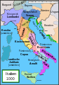
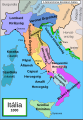
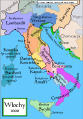
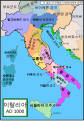
Español: Mapa de Italia hacia el año 1000. Creado por MapMaster, traducido por Molorco
English: Political map of Italy in 1000 AD (CE). Created by MapMaster, translated by Molorco
Part of a series of maps on the history of Italy:
|
| Data | 10 prill 2008 (original upload date) |
| Burimi | No machine-readable source provided. Own work assumed (based on copyright claims). |
| Autori | No machine-readable author provided. Molorco assumed (based on copyright claims). |


Other versions
[redakto]
SVG:
-
 català
 -
 čeština
 -
 Deutsch
 -
 English
 -
 español
 -
 français
 -
 Ido
Ido -
 italiano
 -
 magyar
 -
 polski
 -
 português
 -
 Türkçe
 -
 русский
 -
 українська
 -
 العربية
 -
 עברית
עברית -
 한국어
한국어 -
 中文
中文


PNG:
-
 polski
 -
 Türkçe
 -
 Ελληνικά
 -
 中文
中文


Kjo skedë SVG përdor tekst i cili mund të përkthehet fare lehtë në gjuhën tënde përmes [toolforge:svgtranslate/File:Italy_1000_AD-es.svglink këtij mjeti] në mënyrë automatike. Lexo më tepër. Gjithashtu ju mund ta shkarkoni këtë skedar dhe ta redaktoni manualisht përmes një tekst-editori. |
References
- Bjorklund, Oddvar; Holmboe, Haakon; Rohr, Anders (1970) Historical Atlas of the World, Barnes & Noble, NY, SBN: 389-00253-4.
- This map from Allyn & Bacon, Longman, textbook publishers.
- This map of the w:en:Holy Roman Empire
- A map from Attilios
- This map of 1050 AD Italy, from the 1923 The Historical Atlas by William R. Shepherd
- This map of 1000 AD Italy from Fordham University, adapted from Muir's Historical Atlas, (1911).
In addition, a number of other sources were consulted in an effort to determine the following matters:
- The extent of Venetian control over the cities of Dalmatia such as Zara and Spalato. Although the Venetians had been pushed off the mainland earlier, in the period around the year 1000, the Venetians made an effort to recover these cities.
- The extent of Saracen control over Corsica and Sardinia. Information is sparse. The apparent situation is that the Muslims had several bases on the coasts of these islands, but did not control the countryside (such as they did in Sicily).
- Whether or not the principalities of Capua and Benevento were separate states in the year 1000. Based on lists of their rulers (various Pandulfs and Landulfs), the answer seems to be "yes".
- Who controlled the Balkans on the southeastern border of the Kingdom of Croatia. Candidates include Bulgaria, the Byzantine Empire, Croatia, and Serbia.
As noted, there is significant disagreement among sources on these questions.
This map was commissioned by Attilios, and there is also a discussion to be found on MapMaster's English talk page.
Licencim

|
Ju jepet leje për ta kopjuar, shpërndarë dhe/ose ndryshuar këtë dokument sipas kushteve të Licencës GNU për Dokumentim të Lirë, versioni 1.2 ose çfarëdo versioni të mëpasshëm të botuar nga Free Software Foundation; pa Seksione të Pandryshueshme, pa Tekste Kapakësh të Përparmë, dhe pa Tekste Kapakësh të Pasmë. Një kopje e kësaj licence është përfshirë në seksionin e titulluar GNU Free Documentation License.http://www.gnu.org/copyleft/fdl.htmlGFDLGNU Free Documentation Licensetruetrue |
| Kjo skedë licencohet sipas Creative Commons Attribution-Share Alike 3.0 Unported. | ||
| ||
| Kjo etiketë licencimi u shtua te kjo skedë si pjesë e përditësimit të lincecimit. GFDL.http://creativecommons.org/licenses/by-sa/3.0/CC BY-SA 3.0Creative Commons Attribution-Share Alike 3.0truetrue |
Captions
Items portrayed in this file
përshkruan
10 prill 2008
image/svg+xml
Historiku skedës
Shtypni mbi një datë/kohë për ta parë skedën siç ishte atëherë.
| Data/Koha | Miniaturë | Përmasat | Përdoruesi | Koment | |
|---|---|---|---|---|---|
| e tanishme | 5 gusht 2021 21:56 | | 565 × 811 (710 KB) | Rowanwindwhistler | Cleanup and fake text added |
| 7 gusht 2015 11:37 |  | 565 × 811 (414 KB) | Rowanwindwhistler | Ducado de Amalfi | |
| 7 gusht 2015 11:33 |  | 565 × 811 (414 KB) | Rowanwindwhistler | Easier to read font used, sea colour and coast colour from https://en.wikipedia.org/wiki/Wikipedia:WikiProject_Maps/Conventions | |
| 18 tetor 2008 15:00 |  | 565 × 811 (1,78 MB) | Durero | Borgoña nunca fue un reino | |
| 27 prill 2008 17:42 |  | 565 × 811 (1,82 MB) | Molorco | {{Information |Description= |Source= |Date= |Author= |Permission= |other_versions= }} | |
| 11 prill 2008 17:12 |  | 565 × 811 (1,74 MB) | Molorco | {{Information |Description= |Source= |Date= |Author= |Permission= |other_versions= }} | |
| 10 prill 2008 18:19 |  | 565 × 811 (332 KB) | Molorco | {{Information |Description=Italia año 1000 }} |
Lidhje skedash
S’ka faqe që përdorin këtë kartelë.
Përdorimi global i skedës
Kjo skedë përdoret nga Wiki të tjera në vijim:
- Përdorimi në ar.wikipedia.org
- Përdorimi në ast.wikipedia.org
- Përdorimi në bg.wikipedia.org
- Përdorimi në ca.wikipedia.org
- Përdorimi në en.wikipedia.org
- Përdorimi në es.wikipedia.org
- Historia de Italia
- Roger I de Sicilia
- Principado de Capua
- Guaimario IV de Salerno
- Domenico Selvo
- República amalfitana
- Marca de Verona
- Ducado de Benevento
- Conquista normanda de Italia Meridional
- Principado de Salerno
- Ducado de Spoleto
- Marca de Toscana
- Anexo:Antiguos Estados de Italia
- Reino de Italia (Sacro Imperio Romano Germánico)
- Ducado de Amalfi
- Anexo:Príncipes de Capua
- Emirato de Sicilia
- Reino lombardo
- Batalla de Stilo
- Historia territorial de Italia
- Casa de Cotoner
- Kalbíes
- Historia del islam en el sur de Italia
- Familia Cesina
- Përdorimi në gl.wikipedia.org
- Përdorimi në io.wikipedia.org
- Përdorimi në www.wikidata.org
- Përdorimi në zh.wikipedia.org
Metadata
Kjo skedë përmban hollësira të tjera të cilat mund të jenë shtuar nga kamera ose skaneri dixhital që është përdorur për ta krijuar.
Në qoftë se skeda është ndryshuar nga gjendja origjinale, disa hollësira mund të mos pasqyrojnë versionin e tanishëm.
| Gjerësia | 565.08997 |
|---|---|
| Gjatësia | 811.03571 |