File:Italia_1494.svg
From Wikipedia, the free encyclopedia

Dokument origjinal (skedë SVG, fillimisht 688 × 930 pixel, madhësia e skedës: 418 KB)
| Kjo skedë është prej Wikimedia Commons dhe mund të përdoret nga projekte të tjera. Përshkrimi në këtë skedë në këtë faqe nuk është treguar më poshtë. | Shko tek faqja përshkruese në Commons |
The factual accuracy of this map or the file name is disputed.
Reason: This map and its derivatives need correction and update, as it is mostly based on the Shepherd's map which shows innacurate history of Venetian Republic on Eastern Adriatic, specifically of Dalmatia. It is showing seriouly erroneous and misleading Venetian control over whole region of modern Dalmatia - which became in full extent only in the late 17th and 18th century. It was never the case in the 15th and 16th century, as then most part of Dalmatian hinterland was under Hungarian-Croatian Kingdom and then Ottoman Empire. Venetian Dalmatia at the time included only the very coastal part of Dalmatia with very near hinterland of the Dalmatian city-states, the majority of the hinterland was not Venetian at all. The borders of the Ottoman conquest are also significantly erroneous for the time period as in the map look like modern borders of Bosnia and Herzegovina which became the case only many centuries later. |  |
Përmbledhje
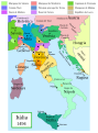
Political map of Italy in early 1494, before the invasion of Italy by Charles VIII of France, created by MapMaster.
This is a companion map to Image:Italy 1000 AD.svg, Image:Italy 1796.png, and Image:Italy c 1810.png.
This map was improved or created by the Wikigraphists of the Graphic Lab (it). You can propose images to clean up, improve, create or translate as well. |
Kjo skedë SVG përdor tekst i cili mund të përkthehet fare lehtë në gjuhën tënde përmes [toolforge:svgtranslate/File:Italy_1494_AD-it.svglink këtij mjeti] në mënyrë automatike. Lexo më tepër. Gjithashtu ju mund ta shkarkoni këtë skedar dhe ta redaktoni manualisht përmes një tekst-editori. |
Versions
[redakto]
PNG:
-
 arabisht
 -
 anglisht
 -
 greqisht


SVG:
-
 katalonisht
 -
 spanjisht
 -
 frëngjisht
 -
 italisht
 -
 hungarisht


See similar versions (disputed too): Map of Italy (1494)
References
- Bjorklund, Oddvar; Holmboe, Haakon; Rohr, Anders (1970) Historical Atlas of the World, Barnes & Noble, NY, SBN: 389-00253-4.
- Matthew, Donald, (1983), Atlas of Medieval Europe, Checkmark Books, New York.
- Online maps, including this 1882 map from Shepherd (the University of Texas)
- this one from A B Longman, textbook publisher.
Licencim

|
Ju jepet leje për ta kopjuar, shpërndarë dhe/ose ndryshuar këtë dokument sipas kushteve të Licencës GNU për Dokumentim të Lirë, versioni 1.2 ose çfarëdo versioni të mëpasshëm të botuar nga Free Software Foundation; pa Seksione të Pandryshueshme, pa Tekste Kapakësh të Përparmë, dhe pa Tekste Kapakësh të Pasmë. Një kopje e kësaj licence është përfshirë në seksionin e titulluar GNU Free Documentation License.http://www.gnu.org/copyleft/fdl.htmlGFDLGNU Free Documentation Licensetruetrue |
| Kjo skedë licencohet sipas Creative Commons Attribution-Share Alike 3.0 Unported. | ||
| ||
| Kjo etiketë licencimi u shtua te kjo skedë si pjesë e përditësimit të lincecimit. GFDL.http://creativecommons.org/licenses/by-sa/3.0/CC BY-SA 3.0Creative Commons Attribution-Share Alike 3.0truetrue |
- Je i lirë të:
- ta shpërndani – ta kopjoni, rishpërndani dhe përcillni punën
- t’i bëni “remix” – të përshtatni punën
- Sipas kushteve të mëposhtme:
- atribuim – Duhet t’i jepni meritat e duhura, të siguroni një lidhje për tek licenca dhe të tregoni nëse janë bërë ndryshime. Këtë mund ta bëni në ndonjë mënyrë të arsyeshme, por jo në ndonjë mënyrë që sugjeron se licencuesi ju del zot juve apo përdorimit tuaj.
- share alike – Nëse bëni një “remix”, e shndërroni, ose ndërtoni duke u bazuar te materiali, duhet t’i shpërndani kontributet tuaja sipas të njëjtës licencë ose një të tille të përputhshme me origjinalen.
derivative works
Derivative works of this file: Italy 1494 AD-fr.svg
Captions
Items portrayed in this file
përshkruan
Historiku skedës
Shtypni mbi një datë/kohë për ta parë skedën siç ishte atëherë.
| Data/Koha | Miniaturë | Përmasat | Përdoruesi | Koment | |
|---|---|---|---|---|---|
| e tanishme | 28 qershor 2013 20:27 | | 688 × 930 (418 KB) | Fulvio314 | Legenda, added small territories |
| 26 maj 2013 22:46 |  | 576 × 812 (417 KB) | Fulvio314 | Font | |
| 27 shkurt 2007 17:31 |  | 567 × 812 (1,17 MB) | MapMaster | Some modifications based on feedback from User:Paolo da Reggio | |
| 23 shkurt 2007 05:31 |  | 567 × 812 (1,17 MB) | MapMaster | Italia, 1494. |
Lidhje skedash
S’ka faqe që përdorin këtë kartelë.
Përdorimi global i skedës
Kjo skedë përdoret nga Wiki të tjera në vijim:
- Përdorimi në ar.wikipedia.org
- Përdorimi në ast.wikipedia.org
- Përdorimi në bg.wikipedia.org
- Përdorimi në br.wikipedia.org
- Përdorimi në el.wikipedia.org
- Përdorimi në en.wikipedia.org
- Përdorimi në eo.wikipedia.org
- Përdorimi në eu.wikipedia.org
- Përdorimi në fi.wikipedia.org
- Përdorimi në fr.wikipedia.org
- Përdorimi në hu.wikipedia.org
- Përdorimi në it.wikipedia.org
- Përdorimi në it.wikiquote.org
- Përdorimi në ja.wikipedia.org
- Përdorimi në ko.wikipedia.org
- Përdorimi në la.wikipedia.org
- Përdorimi në nn.wikipedia.org
- Përdorimi në ru.wikipedia.org
- Përdorimi në uk.wikipedia.org
- Përdorimi në www.wikidata.org
- Përdorimi në zh.wikipedia.org
Metadata
Kjo skedë përmban hollësira të tjera të cilat mund të jenë shtuar nga kamera ose skaneri dixhital që është përdorur për ta krijuar.
Në qoftë se skeda është ndryshuar nga gjendja origjinale, disa hollësira mund të mos pasqyrojnë versionin e tanishëm.
| Gjerësia | 688.25183 |
|---|---|
| Gjatësia | 929.9646 |