File:Black_Sea_map-sv.png
From Wikipedia, the free encyclopedia
Madhësia e këtij shikimi: 786 × 599 pixel. Rezolucione të tjera: 315 × 240 pixel | 630 × 480 pixel | 1.007 × 768 pixel | 1.200 × 915 pixel.
Dokument origjinal ((përmasa 1.200 × 915 px, madhësia skedës: 315 KB, lloji MIME: image/png))
| Kjo skedë është prej Wikimedia Commons dhe mund të përdoret nga projekte të tjera. Përshkrimi në këtë skedë në këtë faqe nuk është treguar më poshtë. | Shko tek faqja përshkruese në Commons |
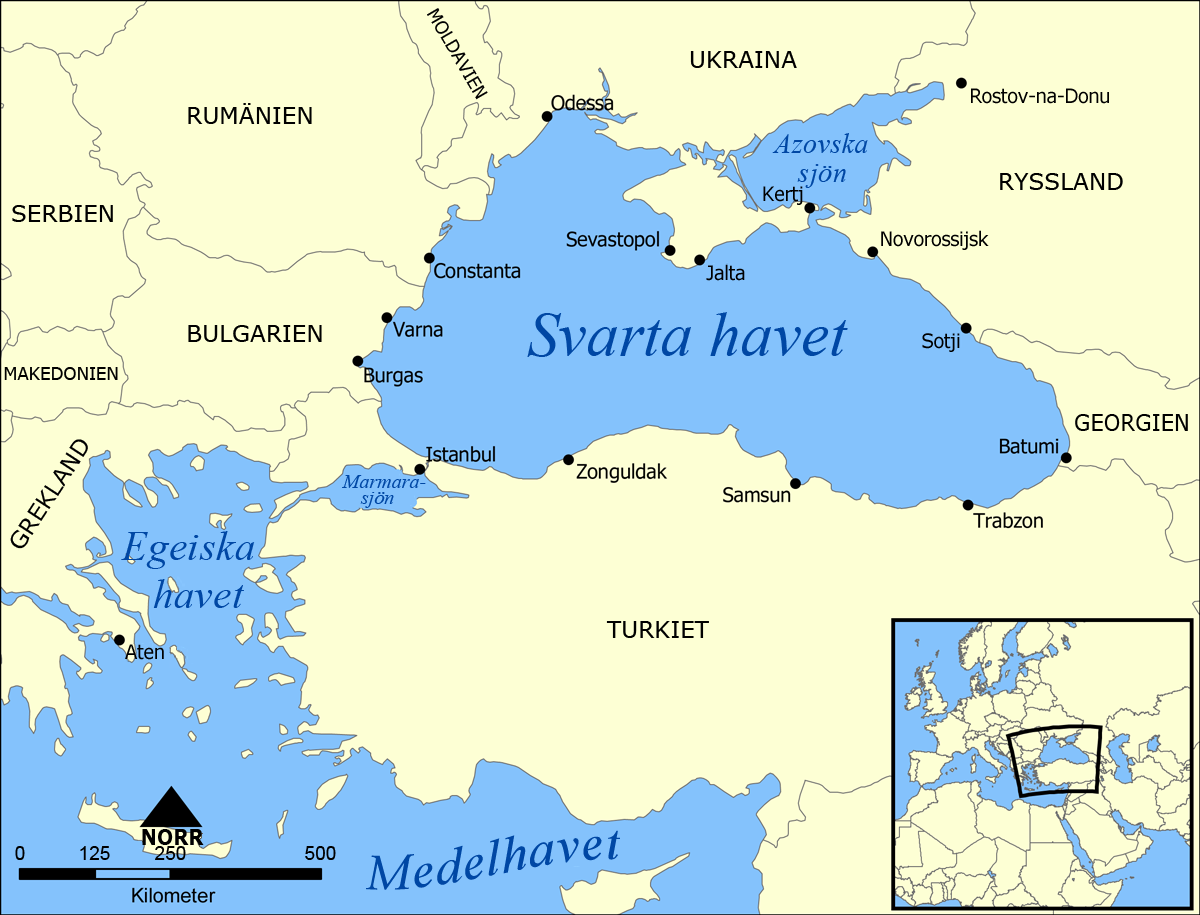
| PërshkrimiBlack Sea map-sv.png | A map showing the location of the Black Sea and some of the large or prominent ports around it. The Sea of Azov and Sea of Marmara are also labelled. |
| Data | (UTC) |
| Burimi | |
| Autori |
|
| Versione tjera |
[redakto]
|


.png)


| This is a retouched picture, which means that it has been digitally altered from its original version. The original can be viewed here: Black Sea map.png:
|
Unë, krijuesi i kësaj pune, e publikoj këtu në bazë të licensës në vijim:
| Kjo skedë licencohet sipas Creative Commons Attribution-Share Alike 3.0 Unported. | ||
| ||
| Kjo etiketë licencimi u shtua te kjo skedë si pjesë e përditësimit të lincecimit. GFDL.http://creativecommons.org/licenses/by-sa/3.0/CC BY-SA 3.0Creative Commons Attribution-Share Alike 3.0truetrue |

|
Ju jepet leje për ta kopjuar, shpërndarë dhe/ose ndryshuar këtë dokument sipas kushteve të Licencës GNU për Dokumentim të Lirë, versioni 1.2 ose çfarëdo versioni të mëpasshëm të botuar nga Free Software Foundation; pa Seksione të Pandryshueshme, pa Tekste Kapakësh të Përparmë, dhe pa Tekste Kapakësh të Pasmë. Një kopje e kësaj licence është përfshirë në seksionin e titulluar GNU Free Documentation License.http://www.gnu.org/copyleft/fdl.htmlGFDLGNU Free Documentation Licensetruetrue |
Mundeni të përzgjidhni licencën që doni.
Regjistri origjinal i ngarkimeve
This image is a derivative work of the following images:
- File:Black_Sea_map.png licensed with Cc-by-sa-3.0-migrated, GFDL
- 2007-07-10T18:10:36Z NormanEinstein 1200x915 (382990 Bytes) Updated maps to add Russian city of Sochi.
- 2007-05-07T19:11:11Z NormanEinstein 1200x912 (378400 Bytes) Corrected city name typo.
- 2006-05-29T13:10:42Z NormanEinstein 1200x914 (136455 Bytes) Reduced image size.
- 2005-07-25T14:54:05Z NormanEinstein 1200x916 (487643 Bytes) A map showing the location of the Black Sea and some of the large or prominent ports around it. The Sea of Azov and Sea of Maramara are also labelled. Created by NormanEinstein, July 25, 2005. {{GFDL-self}} [[Category:Maps
Uploaded with derivativeFX
Captions
Add a one-line explanation of what this file represents
Items portrayed in this file
përshkruan
image/png
checksum anglisht
cb3a0346d98e696f9b90db4ad6139c72228fde36
data size anglisht
322.217 Bajti
915 pixel
1.200 pixel
Historiku skedës
Shtypni mbi një datë/kohë për ta parë skedën siç ishte atëherë.
| Data/Koha | Miniaturë | Përmasat | Përdoruesi | Koment | |
|---|---|---|---|---|---|
| e tanishme | 21 prill 2010 20:22 | | 1.200 × 915 (315 KB) | Inteloutside2 | {{Information |Description=A map showing the location of the Black Sea and some of the large or prominent ports around it. The Sea of Azov and Sea of Marmara are also labelled. |Source=*File:Black_Sea_map.png |Date=2010-04-21 18:22 (UTC) |Author=*[[ |
Lidhje skedash
S’ka faqe që përdorin këtë kartelë.
Përdorimi global i skedës
Kjo skedë përdoret nga Wiki të tjera në vijim:
- Përdorimi në ka.wiktionary.org
- Përdorimi në sv.wikipedia.org