File:Jeddah_map.png
From Wikipedia, the free encyclopedia
Faylka asalka ah (705 × 966 pixels, weyninka faylka : 291 KB, nuuca MIME: image/png)
Faylkaan wuxuu ka socdaa Wikimedia Commons waxaana adeegsan kara mashaariic kale. Sharaxaadda ku taal boggeeda faylka ee bogga sharaxaadda faylka halkan hoose ayaa lagu muujiyey.
Qoraal kooban
| SharaxaadJeddah map.png |
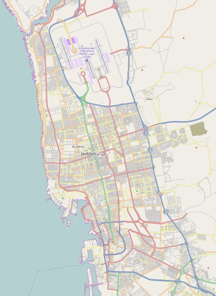
English: A map showing the main street of Jeddah, Saudi Arabia, with King Abdulaziz International Airport at the top. The two highways to Mecca (80 km) leave the map at the lower right-hand corner. |
| Taariikhda | |
| Xigasho | OpenStreetMap |
| Qoraa | Physchim62 using data from OpenStreetMap |
| Camera location | 21° 33′ 50.4″ N, 39° 10′ 58.8″ E | View this and other nearby images on: OpenStreetMap |
|---|
Laysinka
- Waad fasaxantahay:
- la wadaagid – koobi gareenta, qaybinta iyo gudbinta shaqada
- to remix – in shaqada la waafajiyo
- Shuruudaha soo socda:
- Astaan – You must give appropriate credit, provide a link to the license, and indicate if changes were made. You may do so in any reasonable manner, but not in any way that suggests the licensor endorses you or your use.
- si isku mid la wadaag – If you remix, transform, or build upon the material, you must distribute your contributions under the same or compatible license as the original.
Captions
Items portrayed in this file
depicts Ingiriisi
copyright status Ingiriisi
copyrighted Ingiriisi
copyright license Ingiriisi
inception Ingiriisi
27 Nofeembar 2009
coordinates of the point of view Ingiriisi
21°33'50"N, 39°10'59"E
Taariikhda faylka
Riix taariikhda/waqtiga si aad u argto faylka sida oo ahaa markiisa hore.
| Taariikhda/Waqtiga | Sawir yar | Cabirka | Isticmaale | Ka hadalka | |
|---|---|---|---|---|---|
| kan hadda | 16:47, 20 Jannaayo 2015 | | 705 × 966 (291 KB) | Kopiersperre | map updated |
| 07:23, 27 Nofeembar 2009 |  | 456 × 594 (143 KB) | Physchim62 | {{Information |Description={{en|1=A map showing the main street of w:Jeddah, w:Saudi Arabia, with w:King Abdulaziz International Airport at the top. The two highways to w:Mecca (80 km) leave the map at the lower right-hand corner.}} |S |
Faylka lagu isticmaalay
waxyaabaha soo socda ee bog ayaa adeegsanaya faylkaan:
isticmaalka faylka aduunka
Wikisyada kale ee soosocda ayaa adeegsanaya faylka:
- Ku isticmaal ca.wikipedia.org
- Ku isticmaal de.wikipedia.org
- Ku isticmaal en.wikipedia.org
- Ku isticmaal fa.wikipedia.org
- Ku isticmaal he.wikipedia.org
- Ku isticmaal id.wikipedia.org
- Ku isticmaal incubator.wikimedia.org
- Ku isticmaal ja.wikipedia.org
- Ku isticmaal ml.wikipedia.org
- Ku isticmaal ms.wikipedia.org
- Ku isticmaal mt.wikipedia.org
- Ku isticmaal mzn.wikipedia.org
- Ku isticmaal ne.wikipedia.org
- Ku isticmaal nn.wikipedia.org
- Ku isticmaal ru.wikipedia.org
- Ku isticmaal sat.wikipedia.org
- Ku isticmaal sl.wikipedia.org
- Ku isticmaal tg.wikipedia.org
- Ku isticmaal tl.wikipedia.org
- Ku isticmaal tr.wikipedia.org
- Ku isticmaal uz.wikipedia.org
- Ku isticmaal vep.wikipedia.org
- Ku isticmaal vi.wikipedia.org
Metadata
Faylkani wuxuu ka kooban yahay macluumaad dheeri ah, oo laga yaabo inuu ku daray kamaradda dijitaalka ama scanner oo loo isticmaalay in lagu abuuro ama lagu dijitilaasgareeyo.
Haddii faylka wax laga beddelay xaaladdiisii hore, faahfaahinta qaar lagama yaabo inay si buuxda u muujiyaan faylka wax laga beddelay.
| Horizontal resolution | 28.35 dpc |
|---|---|
| Vertical resolution | 28.35 dpc |
| File change date and time | 16:55, 20 Jannaayo 2015 |