File:Spread_of_Christianity_to_AD_600_(1).png
From Wikipedia, the free encyclopedia
Izvorna datoteka (2.187 × 1.619 točk, velikost datoteke: 227 KB, MIME-vrsta: image/png)
Spodaj prikazane informacije so s tamkajšnje opisne strani.
Povzetek
| OpisSpread of Christianity to AD 600 - Atlas of World History.png |
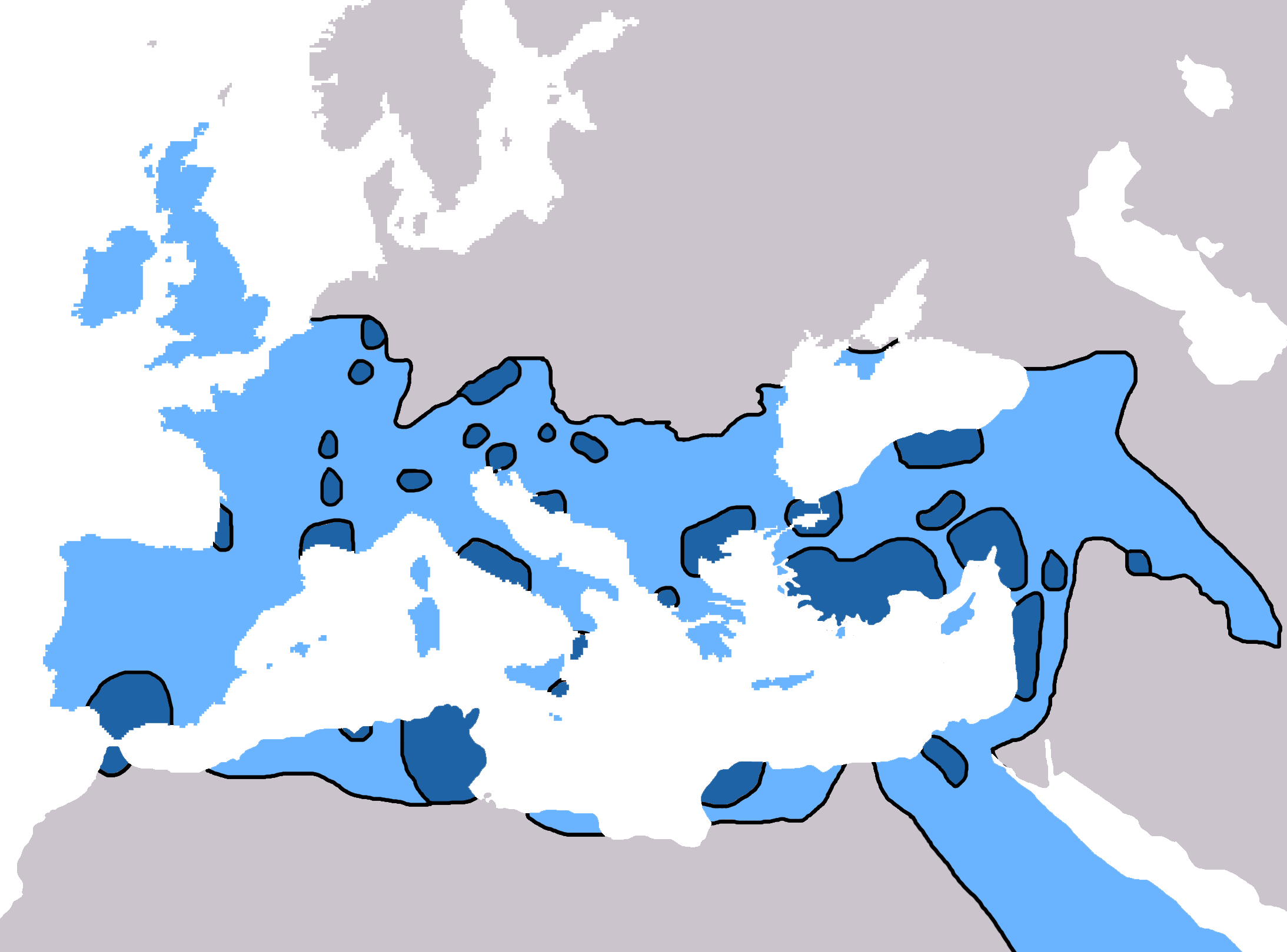
English: Map of the spread of Christianity in Europe, Southwest Asia and North Africa to the year AD 600.
"redominantly Christian by AD 325" zone coloured in dark blue, "Predominantly Christian by AD 600" coloured in light blue.
Magyar: A kereszténység elterjedése:
Information obtained from Patrick O'Brien , ed. (2003) Atlas of World History, Category:New York: Oxford University Press, pp. 44−5 0-19-521921-X Map created and uploaded in the English Wikipedia by Geuiwogbil. Base map: "File:BlankMap-Europe-v3.png" |
| Datum | 27. maj 2009 (izvirni datum naložitve) |
| Vir | Iz en.wikipedia v Zbirko prenesel uporabnik QuartierLatin1968 s pomočjo orodja CommonsHelper. |
| Avtor | Geuiwogbil, sodelavec projekta Wikipedija (jezik: angleščina). |

|
To sliko je mogoče poustvariti z uporabo vektorske grafike kot SVG-datoteko. To ima več prednosti; več informacij je na razpolago na strani Commons:Media for cleanup. Če je SVG-oblika te datoteke že na razpolago, jo, prosimo, naložite. Potem, ko boste SVG naložili, to predlogo zamenjajte z izrazom {{vector version available|ime nove slike.svg}}.
|
Licenca
| Datoteka je objavljena pod licenco Creative Commons Priznanje avtorstva-Deljenje pod enakimi pogoji 3.0 Brez predelav. Predmet zanikanj odgovornosti. | ||
| Avtorstvo: Geuiwogbil iz vikipedije v angleščini | ||
| ||
| Ta oznaka dovoljenja je bila datoteki dodana kot del posodobitve licence GFDL.http://creativecommons.org/licenses/by-sa/3.0/CC BY-SA 3.0Creative Commons Attribution-Share Alike 3.0truetrue |

|
Ta dokument je dovoljeno kopirati, razširjati in/ali spreminjati pod pogoji Licence GNU za prosto dokumentacijo, različica 1.2 ali katera koli poznejša, ki jo je objavila ustanova Free Software Foundation; brez nespremenljivih delov ter brez besedil na sprednji ali zadnji platnici. Kopija licence je vključena v razdelek Licenca GNU za prosto dokumentacijo. Predmet zanikanj odgovornosti.http://www.gnu.org/copyleft/fdl.htmlGFDLGNU Free Documentation Licensetruetrue |
Izvorni dnevniški zapis naložitve
- 2009-05-27 19:20 Carlaude 2187×1619× (232587 bytes) Cutting out unused areas of the map
- 2006-09-09 02:34 Geuiwogbil 2285×2181× (248280 bytes) Blue provides us with a better constrast.
- 2006-09-04 05:10 Geuiwogbil 2285×2181× (254524 bytes)
- 2006-09-04 05:08 Geuiwogbil 2285×2181× (116034 bytes) Map of the spread of Christianity in Europe, Southwest Asia and North Africa to the year 600 AD. Base map "BlankMap-Europe-v.3." Spread of Christianity to AD 325 coloured in orange, to 600 coloured in yellow. Information obtained from {{cite book |editor=
Napisi
Predmeti, prikazani v tej datoteki
motiv
27. maj 2009
image/png
Zgodovina datoteke
Kliknite datum in čas za ogled datoteke, ki je bila takrat naložena.
| Datum in čas | Sličica | Velikost | Uporabnik | Komentar | |
|---|---|---|---|---|---|
| trenutno | 19:31, 3. junij 2022 | | 2.187 × 1.619 (227 KB) | Veverve | Reverted to version as of 10:19, 4 July 2021 (UTC) please bring a map source to counter this claim that only part of Armenia etc. were partially christianised |
| 19:08, 3. junij 2022 |  | 2.187 × 1.619 (245 KB) | Rs4815 | Reverted to version as of 09:58, 24 February 2013 (UTC) You can't just ignore the fact that the "sourced version of the map" has a blunder. By the year 325, the Armenian kingdom had already been converted to Christianity | |
| 12:19, 4. julij 2021 |  | 2.187 × 1.619 (227 KB) | Veverve | Reverted to version as of 12:31, 9 November 2009 (UTC) revert to what is an actually sourced version of the map | |
| 08:34, 23. maj 2018 |  | 2.187 × 1.619 (213 KB) | Inowen | Add labels for Europe, Africa, and Middle East using Inkscape to import previous and overlay text in svg. | |
| 11:58, 24. februar 2013 |  | 2.187 × 1.619 (245 KB) | Prince of Nothing05 | Kingdom of Armenia, Iberia and Caucasian Albania had already made Christianity official religion. | |
| 14:31, 9. november 2009 |  | 2.187 × 1.619 (227 KB) | QuartierLatin1968 | {{Information |Description={{en|Map of the spread of Christianity in Europe, Southwest Asia and North Africa to the year 600 AD. Base map "BlankMap-Europe-v.3." Spread of Christianity to AD 325 coloured in light blue, to 600 coloured in dark blue. Informa |
Uporaba datoteke
Datoteka ni del nobene strani slovenske Wikipedije.
Globalna uporaba datoteke
To datoteko uporabljajo tudi naslednji vikiji:
- Uporaba na ar.wikipedia.org
- Uporaba na arz.wikipedia.org
- Uporaba na be.wikipedia.org
- Uporaba na bg.wikipedia.org
- Uporaba na ca.wikipedia.org
- Uporaba na cs.wikipedia.org
- Uporaba na de.wikipedia.org
- Uporaba na el.wikipedia.org
- Uporaba na en.wikipedia.org
- Christendom
- Christian Church
- Christianity in Africa
- Talk:Christian Church/Archive 1
- Christianity in the Middle East
- Spread of Christianity
- Multiculturalism and Christianity
- Western world
- Christianity in the ante-Nicene period
- Christianity in the 4th century
- Christianity in the 5th century
- Christianity in the 6th century
- Christianity in the 7th century
- Christianity in late antiquity
- Christianity as the Roman state religion
- Roman people
- User:Falcaorib/Medieval Empires (500-650 AD)
- User:Falcaorib/Europe
- Uporaba na en.wikibooks.org
- Uporaba na en.wikiquote.org
- Uporaba na eo.wikipedia.org
- Uporaba na es.wikipedia.org
Oglejte si globalno uporabo te datoteke.
Metapodatki
Datoteka vsebuje še druge podatke, ki jih je verjetno dodal za njeno ustvaritev oziroma digitalizacijo uporabljeni fotografski aparat ali optični bralnik. Če je bila datoteka pozneje spremenjena, podatki sprememb morda ne izražajo popolnoma.
| Vodoravna ločljivost | 28,34 dpc (točke/centimeter) |
|---|---|
| Navpična ločljivost | 28,34 dpc (točke/centimeter) |