Súbor:Map_of_Finland_with_provinces_(numbered).png
From Wikipedia, the free encyclopedia
Nie je dostupné vyššie rozlíšenie.
Map_of_Finland_with_provinces_(numbered).png (150 × 260 pixelov, veľkosť súboru: 2 KB, MIME typ: image/png)
Tento zdieľaný súbor je z Wikimedia Commons a je možné ho používať na iných projektoch. Nižšie sú zobrazené informácie z popisnej stránky súboru.


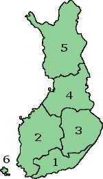
Map of Finland with the Province lines visible (numbered)
(c) adrian.benko, 2005, based on images by (c) helix84, 2005, based on images by (c) Jani Niemenmaa, 2003

|
Bolo udelené povolenie kopírovať, širiť a/alebo meniť tento dokument za podmienok GNU Free Documentation License, verzie 1.2 alebo ktorejkoľvek neskoršej verzie publikovanej Free Software Foundation; bez Nemenných častí, bez Textov na prednej obálke a bez Textov na zadnej obálke. Kópia tejto licencie je zahrnutá v časti nazvanej GNU Free Documentation License.http://www.gnu.org/copyleft/fdl.htmlGFDLGNU Free Documentation Licensetruetrue |
| Tento súbor podlieha licencii Creative Commons Attribution-Share Alike 3.0 Unported | ||
| ||
| Táto šablóna licencie bola pridaná k tomuto súboru počas aktualizácie licencovania GFDL.http://creativecommons.org/licenses/by-sa/3.0/CC BY-SA 3.0Creative Commons Attribution-Share Alike 3.0truetrue |
Štítky
Pridajte jednoriadkové vysvetlenie, čo tento súbor predstavuje
Položky prezentované týmto súborom
motív
História súboru
Po kliknutí na dátum/čas uvidíte ako súbor vyzeral vtedy.
| Dátum/Čas | Náhľad | Rozmery | Používateľ | Komentár | |
|---|---|---|---|---|---|
| aktuálna | 15:37, 12. október 2007 | | 150 × 260 (2 KB) | Skies | Map of Finland with the Province lines visible (numbered) (c) adrian.benko, 2005, based on images by (c) helix84, 2005, based on images by (c) Jani Niemenmaa, 2003 {{GFDL}} [[Category:Locator m |
| 15:34, 12. október 2007 |  | 150 × 260 (2 KB) | Skies | Map of Finland with the Province lines visible (numbered) (c) adrian.benko, 2005, based on images by (c) helix84, 2005, based on images by (c) Jani Niemenmaa, 2003 {{GFDL}} [[Category:Locator m | |
| 18:32, 27. apríl 2005 |  | 150 × 261 (17 KB) | Adrian.benko~commonswiki | Map of Finland with the Province lines visible (numbered) (c) User:adrian.benko, 2005, based on images by (c) helix84, 2005, based on images by (c) Jani Niemenmaa, 2003 {{GFDL}} |
Použitie súboru
Na tento súbor odkazuje nasledujúca stránka:
Globálne využitie súborov
Nasledovné ďalšie wiki používajú tento súbor:
- Použitie na ast.wikipedia.org
- Použitie na be.wikipedia.org
- Použitie na br.wikipedia.org
- Použitie na bs.wikipedia.org
- Použitie na da.wikipedia.org
- Použitie na de.wikivoyage.org
- Použitie na diq.wikipedia.org
- Použitie na el.wikipedia.org
- Použitie na en.wikipedia.org
- Použitie na eu.wikipedia.org
- Použitie na fi.wikipedia.org
- Použitie na fi.wikivoyage.org
- Použitie na fr.wikipedia.org
- Použitie na gag.wikipedia.org
- Použitie na he.wikipedia.org
- Použitie na hu.wikipedia.org
- Použitie na id.wikipedia.org
- Použitie na incubator.wikimedia.org
- Použitie na ko.wikipedia.org
- Použitie na ms.wikipedia.org
- Použitie na oc.wikipedia.org
- Použitie na pl.wikipedia.org
- Použitie na pt.wikipedia.org
- Použitie na ro.wikipedia.org
- Použitie na ru.wikipedia.org
- Použitie na se.wikipedia.org
- Použitie na su.wikipedia.org
- Použitie na tg.wikipedia.org
- Použitie na vec.wikipedia.org
.png)