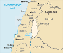
Golan Heights
Syrian territory occupied by Israel, annexed in 1981The Golan Heights is a plateau and a disputed land between Syria and Israel, which captured the area in the Six Day War of 1967. The United Nations has voted to ask Israel to pull its troops out of the Golan Heights. Syria and Israel still have not signed a peace treaty from that war, mostly because of the issue of the Golan. They almost reached a peace deal but they could not agree on where to draw the line, and what Syria would have to do in return. The Golan Heights and Mount Hermon was annexed by Israel in 1981. On the western edge of the Golan Heights is a range of dormant and extinct volcanos.
Read article


