St Kilda
archipelago in Outer Hebrides, Scotland, United Kingdom From Wikipedia, the free encyclopedia
| Gaelic name | Hiort (help·info) |
|---|---|
| Pronunciation | [hirˠʃt̪] |
| Norse name | Possibly Skildir |
| Meaning of name | Unknown, possibly Gaelic for "westland" |
| Location | |
 St Kilda St Kilda shown within Scotland | |
| OS grid reference | 25 |
| Coordinates | 57.8°N 8.6°W |
| Physical geography | |
| Island group | St Kilda |
| Area | 854.6 ha |
| Highest elevation | Conachair 430 m |
| Administration | |
| Sovereign state | United Kingdom |
| Country | Scotland |
| Council area | Comhairle nan Eilean Siar |
| Demographics | |
| Population | Uninhabited since 1930 |
| Largest settlement | Am Baile (the Village) |
| References | [1][2] |
St Kilda is a small archipelago of Hebridean islands. It is northwest of the coast of Scotland. The islands are a UNESCO World Heritage Site.[3]
St Kilda has large seabird colonies. The island has the largest colony of North Atlantic gannets in the world.[4]
History
It is known that people have lived on St Kilda for over 2000 years. The entire population was evacuated from the island in 1930. St Kilda was given to the National Trust for Scotland in 1957.
In the 21st century, the only year-round residents are defence personnel. Many conservation workers, volunteers and scientists spend time on the islands in the summer months.[5]
National Nature Reserve
St Kilda became a National Nature Reserves (NNR) in 1957. It is one of 71 NNRs in Scotland. In 2004, the NNR was expanded. The nearby marine features were added. The islands were also added.
In July 2005, it became one of the few World Heritage Sites to have a "mixed" status for its natural and cultural qualities.[6] They are also a National Scenic Area.
Gallery
 Hirta, Village Bay
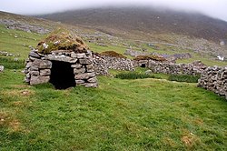 St Kilda cleits were small, turf-covered dry-stone structures used for storage
 St Kilda sheep enclosure
 St Kildans sitting on the village street, 1886
 At the foot of the cliffs, Borrera, 1898
 Catching puffins on St Kilda, 1898


Related pages
References
Other websites
Wikiwand - on
Seamless Wikipedia browsing. On steroids.