Connecticut River

river in the New England region of the United States From Wikipedia, the free encyclopedia

Connecticut River
Remove ads

The Connecticut River is the largest river in New England, which is a region in the eastern United States. It is about 407 miles (655 km) long, with a watershed covering about 11,250 square miles (29,137 square kilometers). Every second, it pours about 19,600 cubic feet (560 cubic meters) per second into its mouth at Long Island Sound, part of the Atlantic Ocean. The river flows through the U.S. states of New Hampshire, Vermont, Massachusetts, and Connecticut. Interstate 91 parallels the river for a notably long distance.
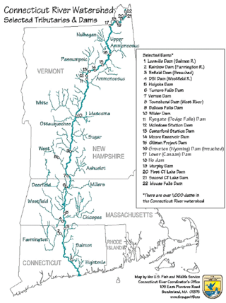
Thumb
Map of the Connecticut River watershed.

The largest city on the Connecticut River is Springfield, Massachusetts. The second largest city is Hartford, Connecticut, the state capital of Connecticut. The two great cities are only 23.9 miles apart (38.5 km.)

Remove ads

Tributaries

Thumb
The Connecticut River near its source
Thumb
A bridge over the river.
Thumb
Mist over the river.
Thumb
The river near Colebrook.

CT denotes Connecticut, VT Vermont, NH New Hampshire, and MA Massachusetts.

  • Black Hall River (CT)
  • Falls River (CT)
  • Eightmile River (CT)
  • Deep River (CT)
  • Salmon River (CT)
  • Mattabesset River (CT)
  • Hockanum River (CT)
  • Park River (CT)
  • Farmington River (CT)
  • Scantic River (CT)
  • Westfield River (MA)
  • Mill River (Springfield, MA)
  • Chicopee River (MA)
  • Manhan River (MA)
  • Mill River (Northampton, MA)
  • Fort River (Hadley, MA)
  • Mill River (Hatfield, MA)
  • Mill River (Amherst, MA)
  • Sawmill River (MA)
  • Deerfield River (MA)
  • Fall River (MA)
  • Millers River (MA)
  • Ashuelot River (NH)
  • West River (VT)
  • Partridge Brook (NH)
  • Cold River (NH)
  • Saxtons River (VT)
  • Williams River (VT)
  • Black River (VT)
  • Little Sugar River (NH)
  • Sugar River (NH)
  • Blow-me-down Brook (NH)
  • Ottauquechee River (VT)
  • Mascoma River (NH)
  • White River (VT)
  • Mink Brook (NH)
  • Ompompanoosuc River (VT)
  • Waits River (VT)
  • Oliverian Brook (NH)
  • Wells River (VT)
  • Ammonoosuc River (NH)
  • Stevens River (VT)
  • Passumpsic River (VT)
  • Johns River (NH)
  • Israel River (NH)
  • Upper Ammonoosuc River (NH)
  • Paul Stream (VT)
  • Nulhegan River (VT)
  • Simms Stream (NH)
  • Mohawk River (NH)
  • Halls Stream (VT)
  • Indian Stream (NH)
  • Perry Stream (NH)
Remove ads
Loading related searches...

Wikiwand - on

Seamless Wikipedia browsing. On steroids.

Remove ads