Apennine Mountains
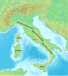
mountain range stretching 1200 km from the north to the south of Italy, traversing the entire peninsula, and forming the backbone of the country From Wikipedia, the free encyclopedia
The Apennines are mountains in Italy. Their highest mountain is Corno Grande which is 2,912 metres high. The Apennines have three main parts: the Northern Apennines, the Central Apennines and the Southern Apennines.
| Apennine Mountains | |
|---|---|
 | |
| Highest point | |
| Peak | Corno Grande (Great Horn) |
| Elevation | 2,912 m (9,554 ft) |
| Coordinates | 42°28′9″N 13°33′57″E |
| Dimensions | |
| Length | 1,200 km (750 mi) northwest to southeast |
| Width | 250 km (160 mi) southwest to northeast |
| Naming | |
| Native name | Monti Appennini (Italian) |
| Geography | |
| Country | Italy San Marino |
| Range coordinates | 43°16.9′N 12°34.9′E |
| Geology | |
| Age of rock | Mesozoic for formation of rock, Neogene-Quaternary for orogeny |
| Type of rock | Apennine fold and thrust belt |
Other websites
![]() Media related to Apennine mountains at Wikimedia Commons
Media related to Apennine mountains at Wikimedia Commons
Wikiwand - on
Seamless Wikipedia browsing. On steroids.

