Ōhura
locality in New Zealand From Wikipedia, the free encyclopedia
locality in New Zealand From Wikipedia, the free encyclopedia
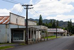
Ōhura is a small town in the Ruapehu District, west of the North Island. It is situated west of Taumarunui in the King Country. It has a primary school and was once the centre of coal mining until 1965, railway network and has hit hard times with the population steadily decreasing since the 1990s. It has Ohura River running the village.
Ōhura | |
|---|---|
Town | |
 Part of the Ōhura township | |
 | |
| Coordinates: 38°50′35″S 174°58′55″E | |
| Country | New Zealand |
| Region | Manawatū-Whanganui |
| District | Ruapehu District |
| Ward |
|
| Community | Taumarunui-Ōhura Community |
| Electorates | |
| Government | |
| • Territorial Authority | Ruapehu District Council |
| • Regional council | Horizons Regional Council |
| Area | |
| • Total | 3.25 km2 (1.25 sq mi) |
| Population (2018 census)[2] | |
| • Total | 126 |
| • Density | 39/km2 (100/sq mi) |
Seamless Wikipedia browsing. On steroids.
Every time you click a link to Wikipedia, Wiktionary or Wikiquote in your browser's search results, it will show the modern Wikiwand interface.
Wikiwand extension is a five stars, simple, with minimum permission required to keep your browsing private, safe and transparent.