Wawa is a township in the Canadian province of Ontario, located within the Algoma District and associated with Wawa Lake. Previously known as the township of Michipicoten, after a nearby river of that name, the township was officially renamed in 2007 for its largest community of Wawa.[3]
Quick Facts Country, Province ...
Wawa |
|---|
|
Municipality of Wawa
Township of Michipicoten (pre-2007) |
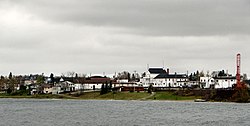 Wawa as seen across Wawa Lake |
|
| Coordinates: 47°59′35″N 84°46′25″W |
| Country | Canada |
|---|
| Province | Ontario |
|---|
| District | Algoma |
|---|
| Established | 1899 |
|---|
|
| • Mayor | Ron Rody |
|---|
| • Federal riding | Algoma—Manitoulin—Kapuskasing |
|---|
| • Prov. riding | Algoma—Manitoulin |
|---|
|
| • Land | 416.21 km2 (160.70 sq mi) |
|---|
Elevation[2]
| Climate data for Wawa Airport (1981−2010) |
| Month |
Jan |
Feb |
Mar |
Apr |
May |
Jun |
Jul |
Aug |
Sep |
Oct |
Nov |
Dec |
Year |
| Record high humidex |
6.7 |
12.3 |
20.1 |
30.6 |
37.1 |
39.0 |
37.1 |
38.9 |
34.9 |
28.3 |
19.7 |
18.5 |
39.0 |
| Record high °C (°F) |
6.8
(44.2) |
11.5
(52.7) |
20.0
(68.0) |
30.3
(86.5) |
31.4
(88.5) |
30.7
(87.3) |
33.1
(91.6) |
34.1
(93.4) |
28.9
(84.0) |
28.0
(82.4) |
19.4
(66.9) |
15.5
(59.9) |
34.1
(93.4) |
| Average high °C (°F) |
−7.7
(18.1) |
−5.4
(22.3) |
−0.2
(31.6) |
7.5
(45.5) |
14.6
(58.3) |
19.0
(66.2) |
20.9
(69.6) |
20.8
(69.4) |
16.6
(61.9) |
9.5
(49.1) |
2.2
(36.0) |
−4.5
(23.9) |
7.8
(46.0) |
| Daily mean °C (°F) |
−14.0
(6.8) |
−11.9
(10.6) |
−6.5
(20.3) |
1.6
(34.9) |
8.1
(46.6) |
12.6
(54.7) |
15.1
(59.2) |
15.3
(59.5) |
11.4
(52.5) |
5.0
(41.0) |
−1.8
(28.8) |
−9.5
(14.9) |
2.1
(35.8) |
| Average low °C (°F) |
−20.2
(−4.4) |
−18.3
(−0.9) |
−12.8
(9.0) |
−4.2
(24.4) |
1.5
(34.7) |
6.1
(43.0) |
9.2
(48.6) |
9.8
(49.6) |
6.1
(43.0) |
0.4
(32.7) |
−5.7
(21.7) |
−14.5
(5.9) |
−3.6
(25.5) |
| Record low °C (°F) |
−40.9
(−41.6) |
−50.0
(−58.0) |
−37.1
(−34.8) |
−25.2
(−13.4) |
−9.4
(15.1) |
−3.4
(25.9) |
0.0
(32.0) |
0.7
(33.3) |
−5.2
(22.6) |
−13.0
(8.6) |
−26.0
(−14.8) |
−39.0
(−38.2) |
−50.0
(−58.0) |
| Record low wind chill |
−51.1 |
−44.6 |
−43.6 |
−30.1 |
−12.4 |
−2.8 |
0.0 |
0.0 |
−6.9 |
−13.1 |
−31.9 |
−46.1 |
−51.1 |
| Average precipitation mm (inches) |
55.7
(2.19) |
46.9
(1.85) |
54.1
(2.13) |
66.9
(2.63) |
77.5
(3.05) |
82.2
(3.24) |
96.1
(3.78) |
92.5
(3.64) |
122.0
(4.80) |
117.5
(4.63) |
85.7
(3.37) |
72.5
(2.85) |
969.7
(38.18) |
| Average rainfall mm (inches) |
2.3
(0.09) |
5.3
(0.21) |
18.8
(0.74) |
47.0
(1.85) |
74.6
(2.94) |
82.2
(3.24) |
96.1
(3.78) |
92.5
(3.64) |
121.8
(4.80) |
107.0
(4.21) |
48.3
(1.90) |
12.0
(0.47) |
707.8
(27.87) |
| Average snowfall cm (inches) |
72.1
(28.4) |
55.8
(22.0) |
40.1
(15.8) |
18.4
(7.2) |
2.8
(1.1) |
0.0
(0.0) |
0.0
(0.0) |
0.0
(0.0) |
0.15
(0.06) |
9.7
(3.8) |
40.5
(15.9) |
79.8
(31.4) |
319.4
(125.7) |
| Average precipitation days (≥ 0.2 mm) |
17.0 |
14.1 |
11.9 |
10.5 |
12.4 |
12.8 |
13.2 |
13.3 |
15.3 |
15.6 |
16.1 |
17.6 |
169.8 |
| Average rainy days (≥ 0.2 mm) |
1.4 |
1.2 |
3.6 |
7.0 |
12.0 |
12.8 |
13.2 |
13.3 |
15.2 |
13.8 |
7.7 |
2.9 |
104.2 |
| Average snowy days (≥ 0.2 cm) |
16.7 |
14.0 |
9.6 |
5.1 |
0.83 |
0.0 |
0.0 |
0.0 |
0.23 |
3.3 |
11.2 |
16.7 |
77.7 |
| Source: Environment Canada[2] |
| 287 m (942 ft) |
|---|
|
| • Total | 2,905 |
|---|
| • Density | 7.0/km2 (18/sq mi) |
|---|
| Time zone | UTC-5 (Eastern Standard Time (EST)) |
|---|
| • Summer (DST) | UTC-4 (Eastern Daylight Time (EDT)) |
|---|
| Postal Code | P0S 1K0 |
|---|
| Area code | 705 |
|---|
| Website | www.wawa.cc |
|---|
Close
This area was first made for fur trading. In the late 19th century, both gold and iron ore were found and mined, leading to the region's rise as the steel industry developed in Sault Ste. Marie, Ontario. From 1900 to 1918 the Helen Mine had the highest production of iron ore of any mine in Canada.
The township includes the smaller communities of Michipicoten and Michipicoten River, which are small port settlements on the shore of Lake Superior. These names are from the Ojibwe term for the river.


