Lake Washington is a lake in the US state of Washington. It is next to the city of Seattle. Seattle is on the west side of the lake, Lake City, Bothell, and Kenmore to the north, Kirkland and Bellevue to the east, and Renton to the south. Mercer Island is in the south end of the lake. The deepest part of the lake is 210 feet (64 m) deep. The lake is 21 feet (6.4 m) above sea level. It is a fresh water lake. On a few days of the year are people allowed to fish for salmon in the lake.
Quick facts Location, Coordinates ...
| Lake Washington |
|---|
 The Lacy V. Murrow floating bridge on the lake is the second longest such bridge in the world |
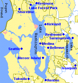 Map of Lakes Washington and Sammamish |
| Location | King County, Washington, USA |
|---|
| Coordinates | 47°37′0″N 122°15′53″W |
|---|
| Primary inflows | Sammamish, Cedar Rivers; Ravenna, Thornton, Kelsey, Juanita, and Coal Creeks |
|---|
| Primary outflows | Lake Washington Ship Canal (1916) |
|---|
| Catchment area | 315,000 acres (1,270 km2) |
|---|
| Basin countries | United States |
|---|
|
| Max. length | 22 mi (35 km) |
|---|
| Surface area | 33.8 square miles (88 km2), 33.8 square miles (21,600 acres) |
|---|
| Average depth | 108 ft (33 m) |
|---|
| Max. depth | 214 ft (65 m) |
|---|
| Water volume | 2,400,000 acre⋅ft (3.0 km3) |
|---|
| Surface elevation | 16 ft (4.9 m) above mean sea level, 20.6 ft (6.3 m) above Puget Sound mean lower low tide |
|---|
|
| Islands | Mercer Island, Foster Island, Marsh Island, Ohler's Island, Pritchard Island |
|---|
Close

