File:2022_Atlantic_hurricane_season_summary_map.png
From Wikipedia, the free encyclopedia
Size of this preview: 800 × 495 pixels. Other resolutions: 320 × 198 pixels | 640 × 396 pixels | 1,024 × 634 pixels | 1,280 × 792 pixels | 2,560 × 1,585 pixels | 4,000 × 2,476 pixels.
Original file (4,000 × 2,476 pixels, file size: 6.11 MB, MIME type: image/png)
| This is a file from the Wikimedia Commons. Information from its description page there is shown below. Commons is a freely licensed media file repository. You can help. |
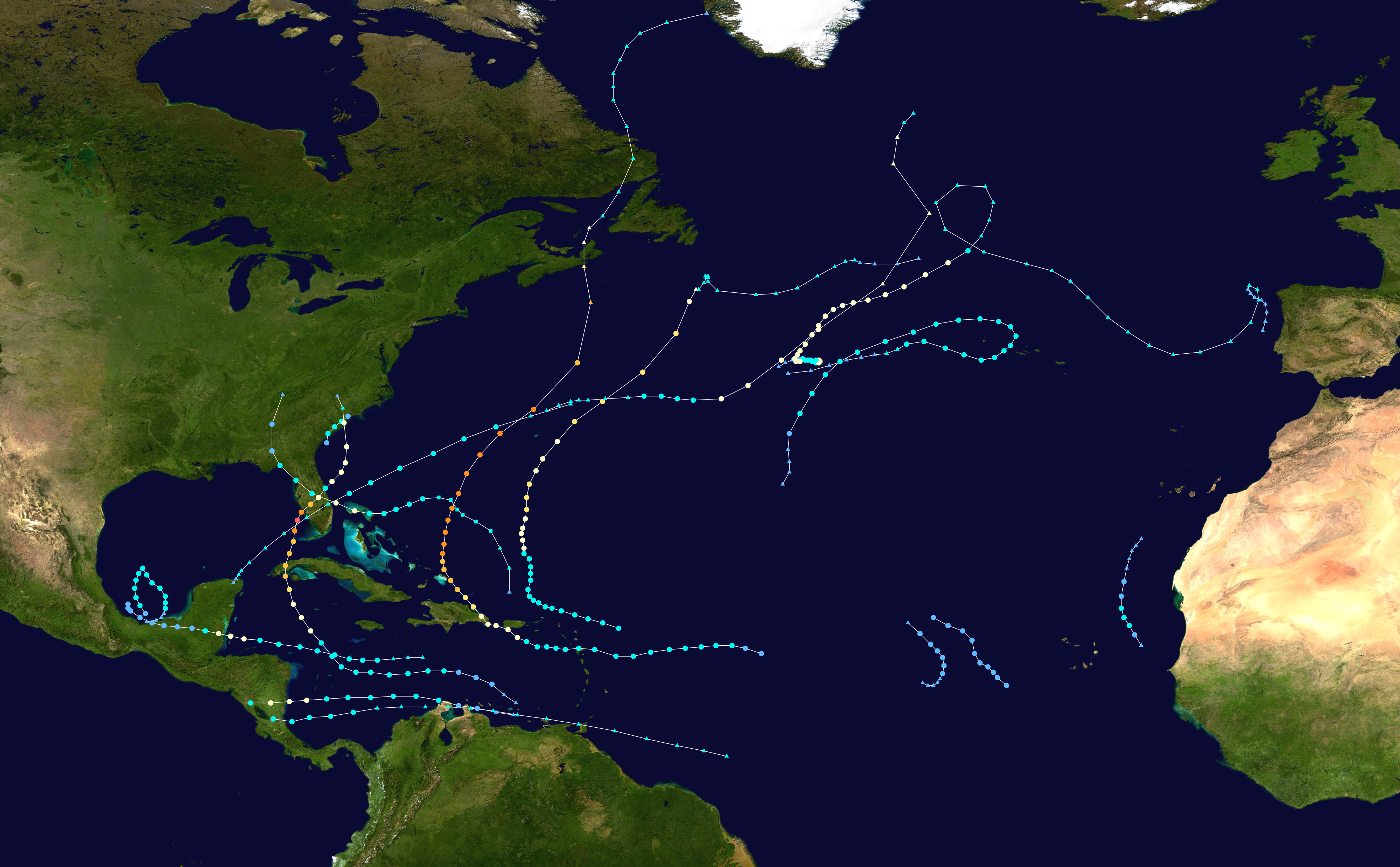
Summary
| Description2022 Atlantic hurricane season summary map.png |
English: This map shows the tracks of all tropical cyclones in the 2022 Atlantic hurricane season. The points show the location of each storm at 6-hour intervals. The colour represents the storm's maximum sustained wind speeds as classified in the Saffir-Simpson Hurricane Scale (see below), and the shape of the data points represent the type of the storm.
Storm type |
| Source | Created using Wikipedia:WikiProject Tropical cyclones/Tracks. The background image is from NASA [1]. The tracking data is from the National Hurricane Center's Atlantic hurricane database |
| Author | HurricaneCovid |

|
This file may be updated to reflect new information. If you wish to use a specific version of the file without new updates being mirrored, please upload the required version as a separate file. |
| Public domainPublic domainfalsefalse |
| This work has been released into the public domain by its author, HurricaneCovid. This applies worldwide. In some countries this may not be legally possible; if so: HurricaneCovid grants anyone the right to use this work for any purpose, without any conditions, unless such conditions are required by law. |
Captions
Map of tracks of all tropical cyclones in the 2022 Atlantic hurricane season
Items portrayed in this file
depicts
image/png
2301f926545c6e119bb4678b1939344dedd964ea
6,409,664 byte
2,476 pixel
4,000 pixel
File history
Click on a date/time to view the file as it appeared at that time.
| Date/Time | Thumbnail | Dimensions | User | Comment | |
|---|---|---|---|---|---|
| current | 14:59, 3 April 2023 | | 4,000 × 2,476 (6.11 MB) | Supportstorm | All TCR tracks |
| 21:12, 19 March 2023 |  | 4,000 × 2,476 (6.16 MB) | Supportstorm | TCR updates | |
| 23:49, 3 March 2023 |  | 4,000 × 2,476 (6.2 MB) | Supportstorm | TCR updates | |
| 18:47, 16 December 2022 |  | 4,000 × 2,476 (6.21 MB) | Supportstorm | 11L TCR | |
| 18:35, 20 November 2022 |  | 4,000 × 2,476 (6.22 MB) | Supportstorm | Updated | |
| 00:14, 10 November 2022 |  | 4,000 × 2,476 (6.21 MB) | Supportstorm | Updated | |
| 23:31, 3 November 2022 |  | 4,000 × 2,476 (6.18 MB) | Supportstorm | Updated | |
| 03:25, 3 November 2022 |  | 4,000 × 2,476 (6.17 MB) | Master0Garfield | fix | |
| 03:24, 3 November 2022 |  | 4,000 × 2,476 (6.17 MB) | Master0Garfield | Update | |
| 00:52, 6 October 2022 |  | 4,000 × 2,476 (6.16 MB) | Supportstorm | Updated |
File usage
The following page uses this file:
Global file usage
The following other wikis use this file:
- Usage on de.wikipedia.org
- Usage on en.wikipedia.org
- Usage on es.wikipedia.org
- Usage on fi.wikipedia.org
- Usage on fr.wikipedia.org
- Usage on it.wikipedia.org
- Usage on ko.wikipedia.org
- Usage on nl.wikipedia.org
- Usage on pt.wikipedia.org
- Temporada de furacões no Atlântico de 2022
- Predefinição:Temporada de furacões no Atlântico de 2022
- Tempestade tropical Alex (2022)
- Furacão Bonnie (2022)
- Furacão Fiona
- Furacão Ian
- Furacão Julia (2022)
- Ciclones tropicais em 2022
- Furacão Nicole (2022)
- Cronologia da temporada de furacões no Atlântico de 2022
- Usage on th.wikipedia.org
- Usage on vi.wikipedia.org
- Usage on www.wikidata.org