Aue-Schwarzenberg
former district of Germany in Saxony From Wikipedia, the free encyclopedia
former district of Germany in Saxony From Wikipedia, the free encyclopedia
Seamless Wikipedia browsing. On steroids.
Every time you click a link to Wikipedia, Wiktionary or Wikiquote in your browser's search results, it will show the modern Wikiwand interface.
Wikiwand extension is a five stars, simple, with minimum permission required to keep your browsing private, safe and transparent.
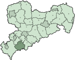
Aue-Schwarzenberg was a rural district in the Free State of Saxony, in the country of Germany. It ended in 2008.
Landkreis Aue-Schwarzenberg | |
|---|---|
 | |
| Coordinates: 50°35′24″N 12°42′00″E | |
| Country | Germany |
| State | Saxony |
| Adm. region | Chemnitz |
| Disbanded | 2008 |
| Capital | Aue |
| Area | |
| • Total | 528.25 km2 (203.96 sq mi) |
| Population (2001) | |
| • Total | 138,331 |
| • Density | 260/km2 (680/sq mi) |
| Time zone | UTC+01:00 (CET) |
| • Summer (DST) | UTC+02:00 (CEST) |
| Vehicle registration | ASZ |
| Website | http://www.lra-asz.de |
The districts of Aue and Schwarzenberg were formed in 1873. In 1994 both districts were joined in order to form a new district, which was called Westerzgebirgskreis (the Western Ore Mountains District). It was renamed Aue-Schwarzenberg in 1995.
The district is located in the western part of the Erzgebirge (ore) Mountains. The tops of these mountains are also the German-Czech border. The highest peak in the district is the Auersberg 1,019 m (3,343 ft), second highest mountain in Saxony.
 |
The coat of arms displays:
|
| Towns | Municipalities | |
|---|---|---|
|
|
|