ගොනුව:Planisphæri_cœleste.jpg
From Wikipedia, the free encyclopedia
මුල් ගොනුව (5,812 × 3,972 පික්සල, ගොනු විශාලත්වය: 19.07 මෙ.බ., MIME ශෛලිය: image/jpeg)
මෙම ගොනුව Wikimedia Commons වෙතින් වන අතර අනෙකුත් ව්යාපෘතීන් විසින්ද භාවිතා කල හැක. එහි ගොනු විස්තර පිටුව තුල අඩංගු විස්තර මෙහි පහත දැක්වෙයි.
සාරාංශය
| කර්තෘ |
creator QS:P170,Q1402952 |
|||||||||||||||||||||||||
| විස්තරය |
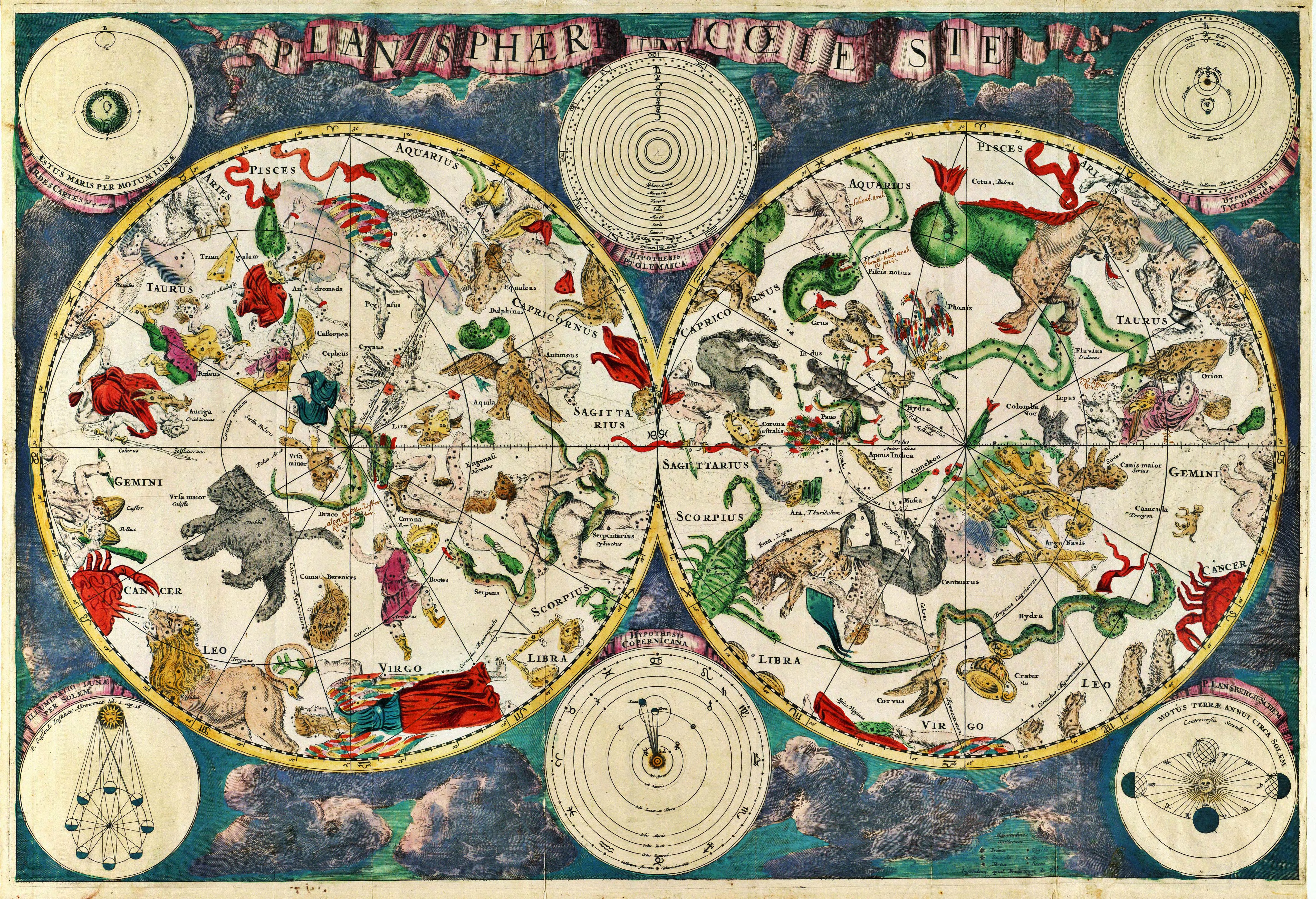
Planisphærium cœleste, denmark, Frederik V English: Celestial map Français : Carte céleste |
|||||||||||||||||||||||||
| දිනය |
1670 date QS:P571,+1670-00-00T00:00:00Z/9 |
|||||||||||||||||||||||||
| යොමුවන් | Koninklijke Deense Bibliotheek | |||||||||||||||||||||||||
| මූලාශ්රය/ඡායාරූප ශිල්පියා | Transferred from en.wikipedia to Commons. Scanned by Janke | |||||||||||||||||||||||||
ප්රකෘති පැටවුම් ලොගය
- 2007-03-10 18:20 Janke 1804×1236×8 (3237455 bytes) Celestial map from the 17th century, by the Dutch cartographer Frederik de Wit. Scanned by uploader
බලපත්රීකරණය
|
This is a faithful photographic reproduction of a two-dimensional, public domain work of art. The work of art itself is in the public domain for the following reason:
The official position taken by the Wikimedia Foundation is that "faithful reproductions of two-dimensional public domain works of art are public domain".
This photographic reproduction is therefore also considered to be in the public domain in the United States. In other jurisdictions, re-use of this content may be restricted; see Reuse of PD-Art photographs for details. | |||||
Captions
Items portrayed in this file
depicts ඉංග්රීසි
inception ඉංග්රීසි
10 මාර්තු 2007
media type ඉංග්රීසි
image/jpeg
ගොනු ඉතිහාසය
එම අවස්ථාවෙහිදී ගොනුව පැවැති ආකාරය නැරඹීමට දිනය/වේලාව මත ක්ලික් කරන්න.
| දිනය/වේලාව | කුඩා-රූපය | මාන | පරිශීලක | පරිකථනය | |
|---|---|---|---|---|---|
| වත්මන් | 10:01, 23 දෙසැම්බර් 2010 | | 5,812 × 3,972 (19.07 මෙ.බ.) | Joopr | Hogere resolutie |
| 00:18, 29 මැයි 2007 |  | 1,804 × 1,236 (3.09 මෙ.බ.) | STyx | {{Information |Description= {{la}}Planisphæri cœleste {{en}}Celestial map from the 17th century, by the Dutch cartographer Frederik de Wit. {{fr}}Carte céleste du XVII ème siècle, réalisée par le cartographe hollandais Frederik de Wit. {{du}}[http |
ගොනු භාවිතය
පහත දැක්වෙන පිටුව විසින් මෙම ගොනුව භාවිතා කෙරෙයි:
ගෝලීය ගොනු භාවිතය
පහත දැක්වෙන අනෙකුත් විකියන් මගින් මෙම ගොනුව භාවිතා කරයි:
- ar.wikipedia.org හි භාවිතය
- ar.wikibooks.org හි භාවිතය
- ast.wikipedia.org හි භාවිතය
- az.wikipedia.org හි භාවිතය
- bar.wikipedia.org හි භාවිතය
- ba.wikipedia.org හි භාවිතය
- bg.wikipedia.org හි භාවිතය
- bn.wikipedia.org හි භාවිතය
- ca.wikipedia.org හි භාවිතය
- cbk-zam.wikipedia.org හි භාවිතය
- ce.wikipedia.org හි භාවිතය
- cs.wikipedia.org හි භාවිතය
- de.wikipedia.org හි භාවිතය
- el.wikipedia.org හි භාවිතය
- en.wikipedia.org හි භාවිතය
- Constellation
- Map
- Astronomy
- Natural philosophy
- Star chart
- Wikipedia:Featured picture candidates/March-2007
- Wikipedia:Featured picture candidates/17th century star map
- User:Sj/olpc dictionary images/500
- Portal:Maps/Maps/Historical
- Portal:Maps/Maps/Historical/7
- Talk:Astronomy/Archive 2
- Wikipedia:Wikipedia Signpost/2013-01-14/WikiProject report
- Wikipedia:Wikipedia Signpost/Single/2013-01-14
- en.wikiquote.org හි භාවිතය
- eo.wikipedia.org හි භාවිතය
- es.wikipedia.org හි භාවිතය
- fa.wikipedia.org හි භාවිතය
- fi.wikipedia.org හි භාවිතය
- fr.wikipedia.org හි භාවිතය
- gl.wikipedia.org හි භාවිතය
මෙම ගොනුවේ තවත් ගෝලීය භාවිත බලන්න.
පාරදත්ත
සමහරවිට ඩිජිටල් කැමරාවක් හෝ ස්කෑනරයක් හෝ භාවිතයෙන්, නිමැවා හෝ සංඛ්යාංකකරණය (ඩිජිටල්කරණය) කොට එක් කල , අමතර තොරතුරු මෙම ගොනුවේ අඩංගුය.
ගොනුව මුලින්ම පැවැති තත්ත්වයෙහි සිට විකරණය කොට තිබේ නම්, සමහරක් තොරතුරු විකරිත ගොනුව පූර්ණ වශයෙන් පිළිඹිමු නොකරනු ඇත.
| _error | 0 |
|---|