File:World_in_300_BCE.PNG
From Wikipedia, the free encyclopedia
මුල් ගොනුව (4,500 × 2,291 පික්සල, ගොනු විශාලත්වය: 1.92 මෙ.බ., MIME ශෛලිය: image/png)
මෙම ගොනුව Wikimedia Commons වෙතින් වන අතර අනෙකුත් ව්යාපෘතීන් විසින්ද භාවිතා කල හැක. එහි ගොනු විස්තර පිටුව තුල අඩංගු විස්තර මෙහි පහත දැක්වෙයි.
සාරාංශය
| විස්තරයWorld in 300 BCE.PNG |
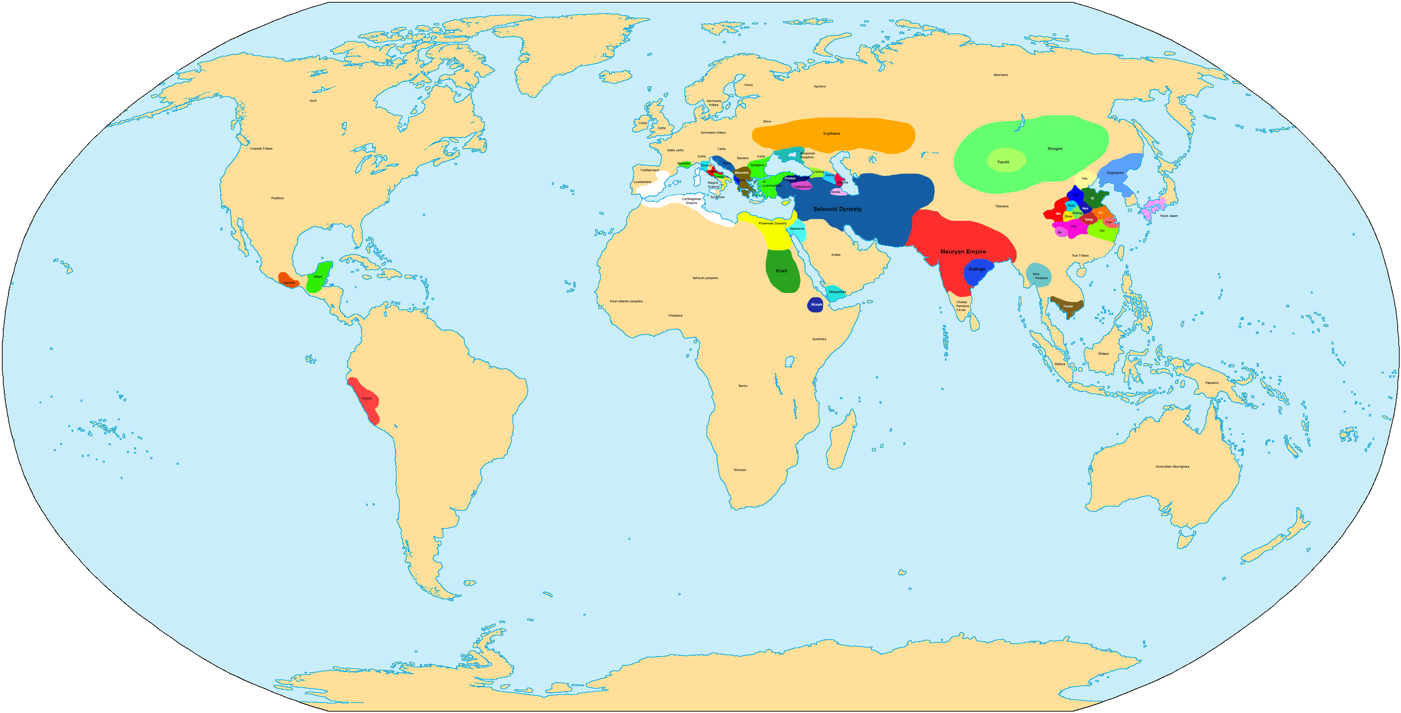
English: Map of the World in 300 BCE.
中文:公元前300年的世界地圖。 |
| මූලාශ්රය | ස්වයං නිර්මාණයකි |
| කර්තෘ | Javierfv1212 |

|
This historical map image could be re-created using vector graphics as an SVG file. This has several advantages; see Commons:Media for cleanup for more information. If an SVG form of this image is available, please upload it and afterwards replace this template with
{{vector version available|new image name}}.
It is recommended to name the SVG file “World in 300 BCE.svg”—then the template Vector version available (or Vva) does not need the new image name parameter. |
| Maps of world history | |
| BC | |
|
| |
| AD |
1 · 50 · 100 · 200 · 250 · 300 · 400 · 500 · 700 · 750 · 820 · 900 · 1200 · 1500 · 1556 · 1648 · 1700 · 1750 · 1815 · 1859 · 1871 · 1914 · 1935 · 1954 · 1989 · 2000 · |
|
Maps of colonization history | |
|
see also: Eastern Hemisphere only maps template (1300BC-1500AD) | |
| (this template: · view · discuss ) | |
.jpg)
._LOC_2001620596.jpg)
බලපත්රීකරණය
| Public domainPublic domainfalsefalse |
| මම, මෙම කාර්යයේ ප්රතිරූපණ අයිති හිමිකරු, මෙම කාර්යය public domain වෙත නිදහස් කරමි. මෙය ලෝක ව්යාප්තව අදාළ වේ. සමහර රටවල මෙය අනීතික විය හැකිය. එසේ වුවහොත්; මම කිසිදු කොන්දේසියකින් තොරව,ඕනෑම අයෙකුට ඕනෑම කාර්යයක් සඳහා මෙය, නීතිමය බාධාවක් නොමැති වනතුරු, භාවිතා කිරීමේ අයිතිය ලබාදෙමි. |
Captions
Items portrayed in this file
depicts ඉංග්රීසි
some value
copyright status ඉංග්රීසි
copyright license ඉංග්රීසි
source of file ඉංග්රීසි
original creation by uploader ඉංග්රීසි
media type ඉංග්රීසි
image/png
ගොනු ඉතිහාසය
එම අවස්ථාවෙහිදී ගොනුව පැවැති ආකාරය නැරඹීමට දිනය/වේලාව මත ක්ලික් කරන්න.
| දිනය/වේලාව | කුඩා-රූපය | මාන | පරිශීලක | පරිකථනය | |
|---|---|---|---|---|---|
| වත්මන් | 18:12, 19 ජූනි 2022 | | 4,500 × 2,291 (1.92 මෙ.බ.) | Luca090902 | Reverted to version as of 01:25, 4 November 2007 (UTC) |
| 01:29, 10 සැප්තැම්බර් 2021 |  | 700 × 356 (132 කි.බ.) | ItsJustdancefan | – | |
| 01:25, 4 නොවැම්බර් 2007 |  | 4,500 × 2,291 (1.92 මෙ.බ.) | Javierfv1212 | ||
| 01:23, 4 නොවැම්බර් 2007 |  | 5,000 × 2,545 (2.12 මෙ.බ.) | Javierfv1212 | {{Information |Description= |Source=self-made |Date= |Author= Javierfv1212 |Permission= |other_versions= }} Category:Maps of the world showing history |
ගොනු භාවිතය
මෙම ගොනුව භාවිතා කරන නිසිදු පිටුවක් නොමැත.
ගෝලීය ගොනු භාවිතය
පහත දැක්වෙන අනෙකුත් විකියන් මගින් මෙම ගොනුව භාවිතා කරයි:
- de.wikipedia.org හි භාවිතය
- en.wikipedia.org හි භාවිතය
- fr.wikipedia.org හි භාවිතය
- gl.wikipedia.org හි භාවිතය
- he.wikipedia.org හි භාවිතය
- id.wikipedia.org හි භාවිතය
- io.wikipedia.org හි භාවිතය
- pt.wikipedia.org හි භාවිතය
- sv.wikipedia.org හි භාවිතය
- zh.wikipedia.org හි භාවිතය
පාරදත්ත
සමහරවිට ඩිජිටල් කැමරාවක් හෝ ස්කෑනරයක් හෝ භාවිතයෙන්, නිමැවා හෝ සංඛ්යාංකකරණය (ඩිජිටල්කරණය) කොට එක් කල , අමතර තොරතුරු මෙම ගොනුවේ අඩංගුය.
ගොනුව මුලින්ම පැවැති තත්ත්වයෙහි සිට විකරණය කොට තිබේ නම්, සමහරක් තොරතුරු විකරිත ගොනුව පූර්ණ වශයෙන් පිළිඹිමු නොකරනු ඇත.
| තිරස් විභේදනය | 28.35 dpc |
|---|---|
| සිරස් විභේදනය | 28.35 dpc |