File:Europe_1867_map_en.png
From Wikipedia, the free encyclopedia
මෙම පෙරදසුනෙහි විශාලත්වය: 800 × 526 පික්සල. අනෙකුත් විභේදනයන්: 320 × 211 පික්සල | 640 × 421 පික්සල | 1,024 × 674 පික්සල | 1,280 × 842 පික්සල | 2,284 × 1,503 පික්සල.
මුල් ගොනුව (2,284 × 1,503 පික්සල, ගොනු විශාලත්වය: 1.07 මෙ.බ., MIME ශෛලිය: image/png)
මෙම ගොනුව Wikimedia Commons වෙතින් වන අතර අනෙකුත් ව්යාපෘතීන් විසින්ද භාවිතා කල හැක. එහි ගොනු විස්තර පිටුව තුල අඩංගු විස්තර මෙහි පහත දැක්වෙයි.
සාරාංශය
| විස්තරයEurope 1867 map en.png |
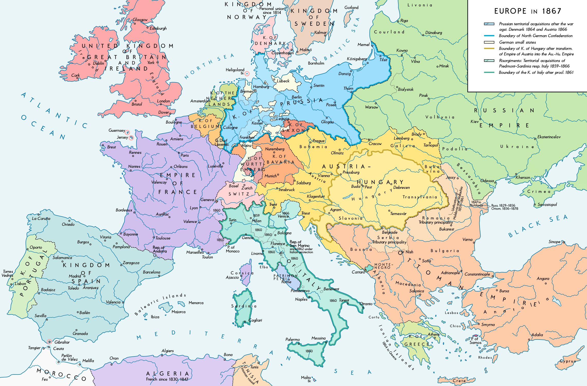
English: Europe 1867. Historical map of the political situation after the forming of the North German Confederation, the Italian Risorgimento (with the exception of the Roman part of the Papal States) and the Austro-Hungarian Compromise of 1867. Please don't alter the map, when you think there something not written or depicted correctly. Leave a message at the talk page of the file. After a verificiation and a possible discussion, i will upload a new map version with all new changes. This prevents an unnecessary waste of disc space and ensures a good result, aesthetically and contentwise. - The author. Deutsch: Europa 1867. Historische Karte der politischen Situation in Europa nach der Gründung des Norddeutschen Bundes, des italienischen Risorgimento (mit Ausnahme des röm. Teils des Kirchenstaats) und dem Österreichisch-Ungarischen Ausgleich von 1867. Bitte die Karte bei Änderungs- und Korrekturwünschen nicht selbst verändern, sondern eine Anmerkung im Diskussionsbereich der Bilddatei hinterlassen. Nach einer Prüfung und ggfs. Diskussion werden evtl. Änderungen von mir zusammengefasst eingearbeitet. Das vermeidet unnötige Speicherplatz-Verschwendung und gewährleistet ein ästhetisch ansprechendes und inhaltlich korrektes Ergebnis. - Der Urheber. |
| දිනය | |
| මූලාශ්රය |
ස්වයං නිර්මාණයකි. Source of Information: Historical atlases and maps – Ramsay Muir, George Philip (ed.): Philip's New School Atlas of Universal History, George Philip & Son, Ltd., London 1928 – Dr. Walter Leisering (ed.): Putzger Historischer Weltatlas, Cornelsen Verlag, Berlin 1992, ISBN 3-464-00176-8 – Bayerischer Schulbuch-Verlag (ed.): Großer Historischer Weltatlas, Dritter Teil, Neuzeit, Bayerischer Schulbuch-Verlag, München 1981, ISBN 3-7627-6021-7. – Prof. Dr. Vadim Oswalt u. Prof. Dr. Hans Ulrich Rudolf (ed.): Klett-Perthes Atlas zur Weltgeschichte, Ernst Klett Verlag, Stuttgart 2011, ISBN 978-3-12-828194-0 – Ziegelbrenner: Karte des Norddeutschen Bundes 1866–1871, 6 June 2014 version (map link) Other publications – Francesco Traniello u. Gianni Sofri: Der lange Weg zur Nation. Das italienische Risorgimento, Verlag W. Kohlhammer, Stuttgart 2012, ISBN 978-3-17-021898-7 |
| කර්තෘ | Alexander Altenhof |
| අනෙකුත් අනුවාදයන් |
|

Recompressed without quality loss with OptiPNG (1.35 MB > 1.06 MB)
බලපත්රීකරණය
මෙම කෘතියෙහි හිමිකම් අයිතීන් දරන්නා වන මම,පහත වරපත යටතේ එය ප්රකාශයට පත් කරමි:
This file is licensed under the Creative Commons Attribution-Share Alike 4.0 International license.
- ඔබ නිදහස්:
- බෙදාහදා ගැනීමට – කාර්යය පිටපත් කිරීමට,බෙදා හැරීමට සහ සම්ප්රේෂණය කිරීමට
- නැවත සංකලනය කිරීමට – කාර්යයට අනුවර්තනය වීමට
- පහත කොන්දේසිවලට යටත්ව:
- attribution – වරපත වෙත බැඳියක්ද සපයමින් ඔබ විසින් සුදුසු කර්තෘභාරය ප්රදානය කල යුතු අතර, කිසියම් වෙනස්වීම් සිදුකලේ නම් එයද සඳහන් කල යුතු වෙයි. ඕනෑම සුදුසු ආකාරයට මෙය ඔබ විසින් සිදුකල හැකි මුත්, වරපත්දායකයා විසින් ඔබ හෝ ඔබගේ භාවිතය හෝ පිටසන් කරන බවට ඇඟවෙන ලෙසින් එය සිදු නොකල යුතු වෙයි.
- share alike – මෙම විෂය කාරණා භාවිතා කොට නැවත සංකලනය, ප්රතියෝජනය හෝ වැඩිදියුණුව කලේ නම්, ඉන්පසු ඔබගේ දායකත්වය ඔබ විසින් බෙදාහැරිය යුත්තේ මුල් වරපත හා සමාන හෝ සංගතික හෝ වරපතක් භාවිතා කරමිනි.
Captions
මෙම ගොනුව නිරූපණය කරන්නෙඑ කුමක්දැයි තනි පේළියේ පැහැදිළි කිරීමක් එක් කරන්න.
Items portrayed in this file
depicts ඉංග්රීසි
some value
copyright status ඉංග්රීසි
copyrighted ඉංග්රීසි
copyright license ඉංග්රීසි
inception ඉංග්රීසි
4 සැප්තැම්බර් 2016
source of file ඉංග්රීසි
original creation by uploader ඉංග්රීසි
ගොනු ඉතිහාසය
එම අවස්ථාවෙහිදී ගොනුව පැවැති ආකාරය නැරඹීමට දිනය/වේලාව මත ක්ලික් කරන්න.
| දිනය/වේලාව | කුඩා-රූපය | මාන | පරිශීලක | පරිකථනය | |
|---|---|---|---|---|---|
| වත්මන් | 23:42, 14 අප්රේල් 2017 | | 2,284 × 1,503 (1.07 මෙ.බ.) | KaterBegemot | Empire of France (not Kingdom), changed main caption to "Europe in 1867", fixed font size of "Piedmont-Sardinia", minor changes |
| 21:36, 4 සැප්තැම්බර් 2016 |  | 2,284 × 1,503 (1.06 මෙ.බ.) | KaterBegemot | {{Information |Description ={{en|1=Europe 1867. Historical map of the political situation after the forming of the North German Confederation, the Italian Risorgimento (with the exception of the Roman part of the Papal States) and the Austro-Hungari... |
ගොනු භාවිතය
මෙම ගොනුව භාවිතා කරන නිසිදු පිටුවක් නොමැත.
ගෝලීය ගොනු භාවිතය
පහත දැක්වෙන අනෙකුත් විකියන් මගින් මෙම ගොනුව භාවිතා කරයි:
- ast.wikipedia.org හි භාවිතය
- en.wikipedia.org හි භාවිතය
- et.wikipedia.org හි භාවිතය
- it.wikipedia.org හි භාවිතය
පාරදත්ත
සමහරවිට ඩිජිටල් කැමරාවක් හෝ ස්කෑනරයක් හෝ භාවිතයෙන්, නිමැවා හෝ සංඛ්යාංකකරණය (ඩිජිටල්කරණය) කොට එක් කල , අමතර තොරතුරු මෙම ගොනුවේ අඩංගුය.
ගොනුව මුලින්ම පැවැති තත්ත්වයෙහි සිට විකරණය කොට තිබේ නම්, සමහරක් තොරතුරු විකරිත ගොනුව පූර්ණ වශයෙන් පිළිඹිමු නොකරනු ඇත.
| තිරස් විභේදනය | 70 dpi |
|---|---|
| සිරස් විභේදනය | 70 dpi |
| වර්ණ අවකාශය | අක්රමාංකිත |
| ප්රතිබිම්බයෙහි පළල | 2,284 px |
| ප්රතිබිම්බයෙහි උස | 1,503 px |
| භාවිතාකල මෘදුකාංග | Adobe Photoshop CC 2017 (Windows) |
| ඩිජිටල්කරන දිනය හා වේලාව | 03:05, 15 අප්රේල් 2017 |
| ගොනුව වෙනස්කල දින හා වේලාව | 03:22, 15 අප්රේල් 2017 |
| පාරදත්ත අවසන් වරට වෙනස්කල දිනය | 03:22, 15 අප්රේල් 2017 |
| මුල් ලියවිල්ලේ අතුල්ය අනන්ය | xmp.did:fd41fa5f-5199-fd40-bec6-d1a7668cc651 |
"https://si.wikipedia.org/wiki/ගොනුව:Europe_1867_map_en.png" වෙතින් සම්ප්රවේශනය කෙරිණි