File:Wawa_footprint_2012-07.png
From Wikipedia, the free encyclopedia
Veličina ovog prikaza: 548 × 599 piksela. Druge rezolucije: 220 × 240 piksela | 439 × 480 piksela | 644 × 704 piksela.
Izvorna datoteka (644 × 704 piksela, veličina datoteke/fajla: 138 kB, MIME tip: image/png)
Ova datoteka je s projekta Vikimedijina ostava i može se upotrebljavati i na drugim projektima. Ispod su prikazane informacije s njene opisne stranice.
Opis izmjene


| Point Maps
══▻ FAQ ◅══ ══▻ Create your own ◅══ |
Licenciranje
Ova datoteka dostupna je pod licencom Creative Commons Attribution-Share Alike 3.0 Unported licencom.
- Slobodno smijete:
- dijeliti – umnožavati, raspodjeljivati i prenositi djelo
- prerađivati – prilagođavati djelo
- Pod sljedećim uslovima:
- pripisivanje – Morate pripisati odgovarajuće autorske zasluge, osigurati link ka licenci i naznačiti jesu li napravljene izmjene. To možete uraditi na bilo koji razumni način, ali ne tako da se sugerira da davalac licence odobrava Vas ili Vašu upotrebu njegovog djela.
- dijeljenje pod istim uslovima – Ako mijenjate, transformišete ili nadograđujete ovaj materijal, morate ga objaviti i distribuirati samo pod istom ili sličnom licencom poput ove.
Izvorna evidencija postavljanja
This image is a derivative work of the following images:
- File:USA_Pennsylvania_location_map.svg licensed with Cc-by-3.0, GFDL
- 2009-07-05T11:11:22Z Alexrk2 1201x805 (429769 Bytes) == Beschreibung == {{Information |Description= {{de|Positionskarte von [[:de:Pennsylvania|Pennsylvania]], [[:de:USA|USA]]}} Quadratische Plattkarte, N-S-Streckung 130.0 %. Geographische Begrenzung der Karte: * N: 42.7° N * S
- File:USA_New_Jersey_location_map.svg licensed with Cc-by-3.0, GFDL
- 2009-06-17T19:59:27Z Alexrk2 839x1560 (259806 Bytes) enh
- 2009-06-13T18:01:16Z Alexrk 839x1560 (198653 Bytes) fixed SVG bug
- 2009-06-13T17:46:17Z Alexrk 839x1560 (246056 Bytes) == Beschreibung == {{Information |Description= {{de|Positionskarte von [[:de:New Jersey|New Jersey]], [[:de:USA|USA]]}} Quadratische Plattkarte, N-S-Streckung 130.0 %. Geographische Begrenzung der Karte: * N: 41.6° N * S: 38
- File:USA_Maryland_location_map.svg licensed with Cc-by-3.0, GFDL
- 2009-06-22T11:30:38Z Alexrk2 1200x764 (463352 Bytes) fixed border
- 2009-06-22T11:23:05Z Alexrk2 1200x764 (459278 Bytes) crop height
- 2009-06-22T11:03:54Z Alexrk2 1201x955 (455501 Bytes) renderer bug
- 2009-06-22T10:42:06Z Alexrk2 800x636 (318450 Bytes) == Beschreibung == {{Information |Description= {{de|Positionskarte von [[:de:Maryland|Maryland]], [[:de:USA|USA]]}} Quadratische Plattkarte, N-S-Streckung 130.0 %. Geographische Begrenzung der Karte: * N: 40.3° N * S: 37.3°
- File:USA_New_York_location_map.svg licensed with Cc-by-3.0, GFDL
- 2009-06-10T11:28:20Z NordNordWest 1572x1277 (597043 Bytes) {{Information |Description= {{de|Positionskarte vom Bundesstaat [[:de:New York (Bundesstaat)|New York]], [[:de:USA|USA]]}} Quadratische Plattkarte, N-S-Streckung 135 %. Geographische Begrenzung der Karte: * N: 45.3° N * S: 4
- File:USA_Virginia_location_map.svg licensed with Cc-by-3.0, GFDL
- 2009-07-06T18:02:25Z Alexrk2 1500x964 (963271 Bytes) resize
- 2009-06-26T16:42:40Z Alexrk2 1201x772 (966691 Bytes) == Beschreibung == {{Information |Description= {{de|Positionskarte von [[:de:Virginia|Virginia]], [[:de:USA|USA]]}} Quadratische Plattkarte, N-S-Streckung 130.0 %. Geographische Begrenzung der Karte: * N: 40.2° N * S: 35.8°
- File:USA_West_Virginia_location_map.svg licensed with Cc-by-3.0, GFDL
- 2009-07-03T15:31:49Z Alexrk2 1201x1118 (535137 Bytes) == Beschreibung == {{Information |Description= {{de|Positionskarte von [[:de:West Virginia|West Virginia]], [[:de:USA|USA]]}} Quadratische Plattkarte, N-S-Streckung 130.0 %. Geographische Begrenzung der Karte: * N: 40.8° N *
- File:USA_Florida_location_map.svg licensed with Cc-by-3.0
- 2008-12-15T20:25:08Z Sting 1132x1096 (591820 Bytes) Counties boundaries: thinner strokes
- 2008-12-15T19:49:40Z Sting 1132x1096 (591829 Bytes) == Summary == {{Location|27|45|00|N|83|49|30|W|scale:4000000}} {{Information |Description={{en|Blank administrative map of the State of [[:en:Florida|Florida]], [[:en:United States|USA]], for geo-location purpose, with count
- File:USA_Connecticut_location_map.svg licensed with Cc-by-3.0, GFDL
- 2009-06-25T19:16:48Z Alexrk2 800x678 (154250 Bytes) renderer bug
- 2009-06-25T19:14:39Z Alexrk2 800x678 (155149 Bytes) == Beschreibung == {{Information |Description= {{de|Positionskarte von [[:de:Connecticut|Connecticut]], [[:de:USA|USA]]}} Quadratische Plattkarte, N-S-Streckung 130.0 %. Geographische Begrenzung der Karte: * N: 42.3° N * S:
- File:USA_North_Carolina_location_map.svg licensed with Cc-by-3.0, GFDL
- 2010-04-25T12:44:25Z Alexrk2 1400x849 (1201046 Bytes) enh rivers, aligned state borders
- 2009-06-26T22:06:53Z Alexrk2 1400x849 (894030 Bytes) resize
- 2009-06-26T21:57:18Z Alexrk2 1400x849 (896940 Bytes) resize
- 2009-06-26T21:47:07Z Alexrk2 1201x728 (930560 Bytes) == Beschreibung == {{Information |Description= {{de|Positionskarte von [[:de:North Carolina|North Carolina]], [[:de:USA|USA]]}} Quadratische Plattkarte, N-S-Streckung 120.0 %. Geographische Begrenzung der Karte: * N: 37.5° N
- File:USA_Delaware_location_map.svg licensed with Cc-by-3.0, GFDL
- 2009-06-22T10:54:18Z Alexrk2 470x800 (106507 Bytes) renderer bug
- 2009-06-22T10:39:54Z Alexrk2 470x800 (66078 Bytes) == Beschreibung == {{Information |Description= {{de|Positionskarte von [[:de:Delaware|Delaware]], [[:de:USA|USA]]}} Quadratische Plattkarte, N-S-Streckung 130.0 %. Geographische Begrenzung der Karte: * N: 40.0° N * S: 38.3°
Uploaded with derivativeFX
Opisi
Dodajte objašnjenje u jednom redu što predstavlja ova datoteka
Predmeti pokazani na ovoj datoteci
prikazuje
status autorskog prava Bosanski
zaštićeno autorskim pravima Bosanski
licenca Bosanski
Creative Commons Autorstvo-Deliti pod istim uslovima 3.0 nelokalizovana Srpski (transliteracija)
31 juli 2012
Historija datoteke
Kliknite na datum/vrijeme da biste vidjeli tadašnju verziju datoteke.
| Datum/vrijeme | Minijatura | Dimenzije | Korisnik | Komentar | |
|---|---|---|---|---|---|
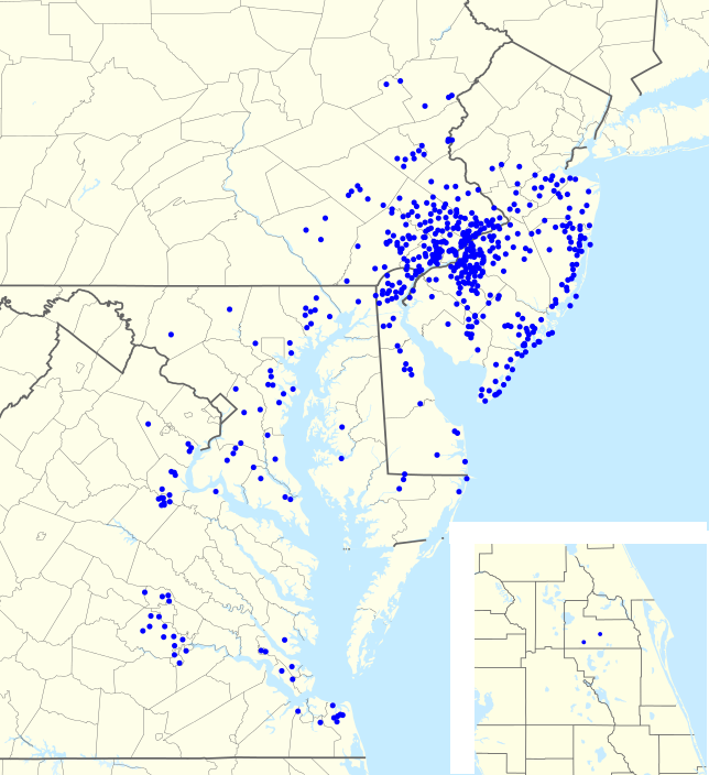
| aktualna | 00:57, 1 august 2012 | | 644 × 704 (138 kB) | Magog the Ogre | == {{int:filedesc}} == {{Information |Description={{en|1=Footprint of en:Wawa Inc. as of {{ISOdate|2011-06-25}}.}} |Source={{Derived from|USA_Pennsylvania_location_map.svg|USA_New_Jersey_location_map.svg|USA_Maryland_location_map.svg|USA_New_York... |
Upotreba datoteke
Nema stranica koje koriste ovu datoteku.
Metapodaci
Ova datoteka sadrži dodatne podatke koje je vjerovatno dodala digitalna kamera ili skener tokom snimanja ili digitalizacije. Ako je datoteka mijenjana, podaci možda nisu u skladu sa stvarnim stanjem.
| Horizontalna rezolucija | 35,43 dpc |
|---|---|
| Vertikalna rezolucija | 35,43 dpc |
| Vrijeme i datum promjene datoteke | 22:42, 31 juli 2012 |