File:East-Hem_475ad.jpg
From Wikipedia, the free encyclopedia
Izvorna datoteka (3.240 × 1.903 piksela, veličina datoteke/fajla: 753 kB, MIME tip: image/jpeg)
Ova datoteka je s projekta Vikimedijina ostava i može se upotrebljavati i na drugim projektima. Ispod su prikazane informacije s njene opisne stranice.

|
This historical map image could be re-created using vector graphics as an SVG file. This has several advantages; see Commons:Media for cleanup for more information. If an SVG form of this image is available, please upload it and afterwards replace this template with
{{vector version available|new image name}}.
It is recommended to name the SVG file “East-Hem 475ad.svg”—then the template Vector version available (or Vva) does not need the new image name parameter. |
 | This historical map image was uploaded in the JPEG format even though it consists of non-photographic data. This information could be stored more efficiently or accurately in the PNG or SVG format. If possible, please upload a PNG or SVG version of this image without compression artifacts, derived from a non-JPEG source (or with existing artifacts removed). After doing so, please tag the JPEG version with {{Superseded|NewImage.ext}} and remove this tag. This tag should not be applied to photographs or scans. If this image is a diagram or other image suitable for vectorisation, please tag this image with {{Convert to SVG}} instead of {{BadJPEG}}. If not suitable for vectorisation, use {{Convert to PNG}}. For more information, see {{BadJPEG}}. |  |
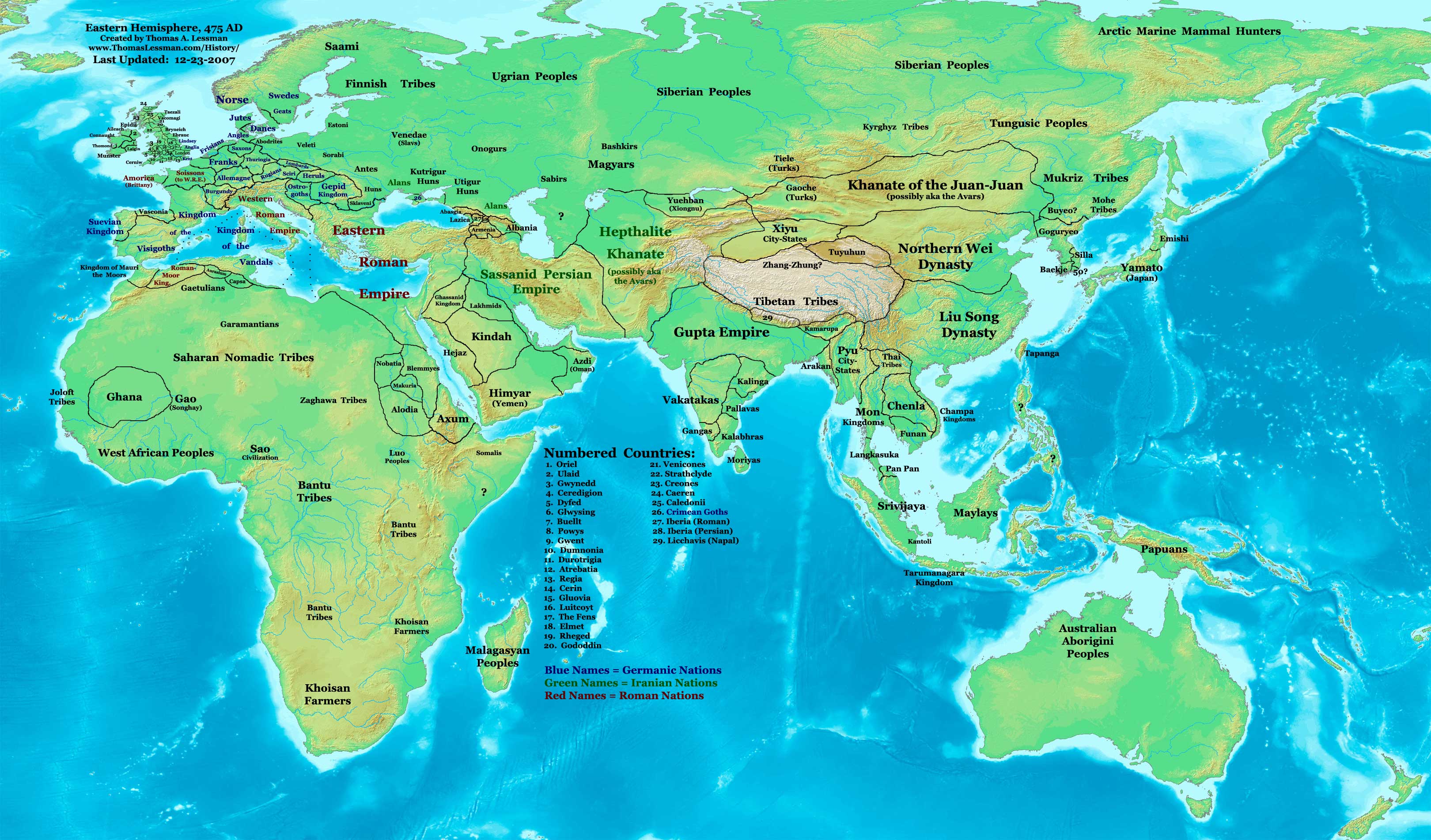
| OpisEast-Hem 475ad.jpg | Eastern Hemisphere in 475 AD. |
| Izvor | self-made (For reference information, see the Map Source References section below.) |
| Autor | Thomas Lessman (Contact!) |
| Dopuštenje (Ponovna upotreba ove datoteke) |
Ja, vlasnik autorskog prava ovog djela, ovdje ga objavljujem pod sljedećom licencom: Ova datoteka dostupna je pod licencom Creative Commons Attribution-Share Alike 3.0 Unported licencom.
|
| Ostale verzije |
see the East-Hem 475ad.jpg File History section below.
Map SummaryOriginal Source URL: http://www.thomaslessman.com/History/images/East-Hem_475ad.jpg. This map of the Eastern Hemisphere in 475 AD was created by Thomas Lessman, based on information from the sources listed below. This map is free for educational use (see Permission info above). When using this map, please mention that it is available for free at www.WorldHistoryMaps.info.
Map Source References
References for information contained in this map: 1. Borders of Europe are mostly derived from the Euratlas.com map of Europe in 500 AD. 2. Borders of Britain are derived from the "EarlyBritishKingdoms.com", map of map Britain in 475 AD. 3. Borders of Asian countries derive from various Wikipedia articles and Google history map searches. 4. Some information is derived from Wikimedia's map of The world in 500 CE, created by User:Javierfv1212. 5. Much of the information in this map was cross-checked with Bruce Gordon's Regnal Chronologies. |
Other Historical Maps by Thomas Lessman
| Maps of the eastern hemisphere showing history
Bold dates are available on Wikimedia or Wikipedia. | ||
| Primeval | ||
| Ancient
|
·| 600 BC | 550 BC | 527 BC | 500 BC |
400 BC | ·| 1 AD | 50 AD | 100 AD | 200 AD | 300 AD | | |
| Medieval |
·| 500 AD | 565 AD | 600 AD | 700 AD | | |
| Modern |
·| 1500 AD | · * For historical maps of the whole world, | |
| history links talk edit view | ||
Opisi
Predmeti pokazani na ovoj datoteci
prikazuje
Ovo svojstvo ima vrijednost, ali nije poznato
status autorskog prava Bosanski
zaštićeno autorskim pravima Bosanski
licenca Bosanski
Creative Commons Autorstvo-Deliti pod istim uslovima 3.0 nelokalizovana Srpski (transliteracija)
vrsta medija na Internetu Serbian (Latin script)
image/jpeg
Historija datoteke
Kliknite na datum/vrijeme da biste vidjeli tadašnju verziju datoteke.
| Datum/vrijeme | Minijatura | Dimenzije | Korisnik | Komentar | |
|---|---|---|---|---|---|
| aktualna | 17:17, 7 februar 2008 | | 3.240 × 1.903 (753 kB) | Rottweiler | {{Information |Description= == Summary == Author: Thomas A. Lessman. Source URL: http://www.ThomasLessman.com/History/images/East-Hem_475ad.jpg. Image was created by Thomas Lessman based on historical information located in sources listed below. This map |
Upotreba datoteke
Sljedeća stranica koristi ovu datoteku:
Globalna upotreba datoteke
Ovu datoteku upotrebljavaju i sljedeći projekti:
- Upotreba na projektu ar.wikipedia.org
- Upotreba na projektu ce.wikipedia.org
- Upotreba na projektu de.wikipedia.org
- Upotreba na projektu el.wikipedia.org
- Upotreba na projektu en.wikipedia.org
- Upotreba na projektu es.wikipedia.org
- Upotreba na projektu fr.wikipedia.org
- Upotreba na projektu rue.wikipedia.org
- Upotreba na projektu ru.wikipedia.org
- Upotreba na projektu sv.wikipedia.org
- Upotreba na projektu ta.wikipedia.org
Metapodaci
Ova datoteka sadrži dodatne podatke koje je vjerovatno dodala digitalna kamera ili skener tokom snimanja ili digitalizacije. Ako je datoteka mijenjana, podaci možda nisu u skladu sa stvarnim stanjem.
| _error | 0 |
|---|