File:Colonisation_1885.png
From Wikipedia, the free encyclopedia
Izvorna datoteka (1.200 × 526 piksela, veličina datoteke/fajla: 206 kB, MIME tip: image/png)
Ova datoteka je s projekta Vikimedijina ostava i može se upotrebljavati i na drugim projektima. Ispod su prikazane informacije s njene opisne stranice.
| References for this description (or part of this) or for the depiction in the file are not provided. |
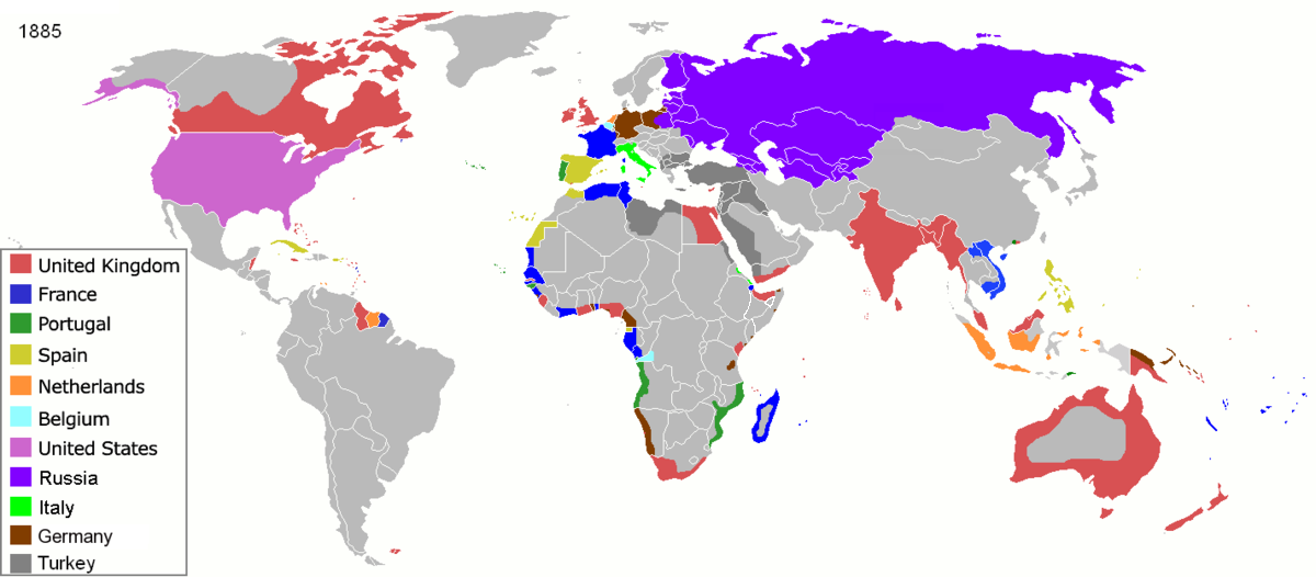
| OpisColonisation 1885.png |
Map of major world powers by year, derived from public domain animated map on wikipedia.
As the orriginal licence of the animation was Public Domain, this image which has been derived from it is too:
|
|||||||||||||||||||
| Datum | ||||||||||||||||||||
| Izvor | public domain animated map by ArdadN here | |||||||||||||||||||
| Autor | ArdadN | |||||||||||||||||||
.jpg)
._LOC_2001620596.jpg)

|
This historical map image could be re-created using vector graphics as an SVG file. This has several advantages; see Commons:Media for cleanup for more information. If an SVG form of this image is available, please upload it and afterwards replace this template with
{{vector version available|new image name}}.
It is recommended to name the SVG file “Colonisation 1885.svg”—then the template Vector version available (or Vva) does not need the new image name parameter. |
Opisi
licenca Bosanski
22 mart 2007
vrsta medija na Internetu Serbian (Latin script)
image/png
kontrolna suma Srpski (transliteracija)
831fd10c262a996a3291205f48ebb3278f0cca4d
veličina podatka Srpski (transliteracija)
210.626 Bajt
526 piksel
1.200 piksel
Historija datoteke
Kliknite na datum/vrijeme da biste vidjeli tadašnju verziju datoteke.
| Datum/vrijeme | Minijatura | Dimenzije | Korisnik | Komentar | |
|---|---|---|---|---|---|
| aktualna | 11:05, 8 novembar 2021 | | 1.200 × 526 (206 kB) | Randomastwritter | jubaland |
| 11:52, 5 april 2020 |  | 1.200 × 526 (206 kB) | Ориенталист | South Sakhalin was part of Russia in 1885 | |
| 13:17, 2 maj 2015 |  | 1.425 × 625 (49 kB) | Chrischerf | German Empire and colonies in 1885; Sudan under control of the Mahdi | |
| 04:57, 3 august 2014 |  | 1.425 × 625 (54 kB) | Alvin Lee | correcting the boundaries of Russia and China | |
| 15:54, 3 novembar 2013 |  | 1.425 × 625 (78 kB) | McZusatz | Reverted to version as of 00:22, 24 January 2011 [corrupt file?] | |
| 17:24, 3 novembar 2012 |  | 1.425 × 625 (67 kB) | Franco310397 | Spanish presence in Micronesia (Oceania) included in the Captaincy General of the Philippines. In the Caroline Islands and the Mariana Islands. | |
| 02:22, 24 januar 2011 |  | 1.425 × 625 (78 kB) | Micsha~commonswiki | Reverted to version as of 02:17, 3 May 2010 | |
| 02:22, 24 januar 2011 |  | 506 × 326 (85 kB) | Micsha~commonswiki | Only Africa; includes map key | |
| 04:17, 3 maj 2010 |  | 1.425 × 625 (78 kB) | Kieran4 | slight edit | |
| 04:14, 3 maj 2010 |  | 1.425 × 625 (78 kB) | Kieran4 | Correct Dutch East INdies |
Upotreba datoteke
Nema stranica koje koriste ovu datoteku.
Globalna upotreba datoteke
Ovu datoteku upotrebljavaju i sljedeći projekti:
- Upotreba na projektu am.wikipedia.org
- Upotreba na projektu de.wikipedia.org
- Upotreba na projektu en.wikipedia.org
- Upotreba na projektu es.wikipedia.org
- Upotreba na projektu fr.wikipedia.org
- Upotreba na projektu he.wikipedia.org
- Upotreba na projektu oc.wikipedia.org
- Upotreba na projektu sk.wikipedia.org
Metapodaci
Ova datoteka sadrži dodatne podatke koje je vjerovatno dodala digitalna kamera ili skener tokom snimanja ili digitalizacije. Ako je datoteka mijenjana, podaci možda nisu u skladu sa stvarnim stanjem.
| PNG komentar datoteke | |
|---|---|
| Horizontalna rezolucija | 47,24 dpc |
| Vertikalna rezolucija | 47,24 dpc |
| Korišteni softver |
|