فائل:Zalzala_Jazeera_2013_Gwadar.jpg
From Wikipedia, the free encyclopedia
Zalzala_Jazeera_2013_Gwadar.jpg (720 × 480 عڪسلون، فائيل سائيز: 94 KB، MIME ٽائيپ: image/jpeg)
ھي فائيل وڪيميڊيا العام مان آھي ۽ ٻين رٿائن پاران پڻ استعمال ٿي سگهي ٿو. تشريح انجي [فائيل جي تشريحي صفحي] ھيٺان ڏنل آھي.
تَتُ
| تشريحZalzala Jazeera 2013 Gwadar.jpg |
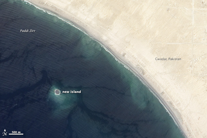
English: Zalzala Jazeera (Earthquake Island) appears near the center of this image of the bay west of Gwadar, Pakistan.
On September 26, 2013, the Advanced Land Imager (ALI) on NASA’s Earth Observing-1 (EO-1) satellite captured the top image of that new island, which sits roughly one kilometer (0.6 miles) offshore. Likely a “mud volcano,” the island rose from the seafloor near Gwadar on September 24, shortly after the earthquake struck about 380 kilometers (230 miles) inland. File:Gwadar satellite view.jpg, acquired by the Operational Land Imager on the Landsat 8 satellite, shows the same area on April 17, 2013. In the satellite images, lighter shades of green and tan in the water reveal shallow seafloor or suspended sediment. The water depth around the new island is roughly 15 to 20 meters, according to marine geologist Asif Inam of Pakistan’s National Institute of Oceanography. “The floor in that area is generally flat, but the gradient in this area changes quite abruptly,” Inam said. The top image from ALI is also clear enough to show the parallel ripples of waves marching toward the shore. |
| تاريخ | |
| ذريعو | http://earthobservatory.nasa.gov/NaturalHazards/view.php?id=82146 |
| ليکڪ | NASA |
| Other versions |
 |
| Camera location | ٢٥° ١٠′ ٤٦٫٥٦″ N, ٦٢° ١٣′ ٥٠٫٥٢″ E | View this and other nearby images on: OpenStreetMap |
|---|
لائيسنسڪاري
| Public domainPublic domainfalsefalse |
| This file is in the public domain in the United States because it was solely created by NASA. NASA copyright policy states that "NASA material is not protected by copyright unless noted". (See Template:PD-USGov, NASA copyright policy page or JPL Image Use Policy.) | ||
 |
Warnings:
|
عنوان
Items portrayed in this file
depicts انگريزي
inception انگريزي
27 سيپٽمبر 2013
coordinates of the point of view انگريزي
25°10'46.6"N, 62°13'50.5"E
فائيل جي سوانح
ڪنھن بہ تاريخ/وقت تي ٽڙڪ ڪري ڏسندا تہ ان وقت اهو فائيل ڪيئن هو.
| تاريخ/وقت | آڱوٺي ننھن | ماپَ | واپرائيندڙ | راءِ | |
|---|---|---|---|---|---|
| موجود نسخو | 01:33, 28 سيپٽمبر 2013 | | 720 × 480 (94 KB) | Rehman | official nasa crop |
| 01:18, 28 سيپٽمبر 2013 |  | 459 × 486 (30 KB) | Ke4roh | User created page with UploadWizard |
ڳنڍڻا
هن فائيل سان هيٺيان صفحا ڳنڍيل آهن.
گلوبل فائيل جو استعمال
ھيٺيون وڪيز بہ ھيءُ فائيل استعمال ڪن ٿيون:
- ar.wikipedia.org تي استعمال
- as.wikipedia.org تي استعمال
- az.wikipedia.org تي استعمال
- bn.wikipedia.org تي استعمال
- ca.wikipedia.org تي استعمال
- cs.wikipedia.org تي استعمال
- el.wikipedia.org تي استعمال
- en.wikipedia.org تي استعمال
- es.wikipedia.org تي استعمال
- fa.wikipedia.org تي استعمال
- fi.wikipedia.org تي استعمال
- fr.wikipedia.org تي استعمال
- id.wikipedia.org تي استعمال
- incubator.wikimedia.org تي استعمال
- it.wikipedia.org تي استعمال
- ja.wikipedia.org تي استعمال
- nl.wikipedia.org تي استعمال
- pnb.wikipedia.org تي استعمال
- ru.wikipedia.org تي استعمال
- scn.wikipedia.org تي استعمال
- simple.wikipedia.org تي استعمال
- sr.wikipedia.org تي استعمال
- tr.wikipedia.org تي استعمال
- uk.wikipedia.org تي استعمال
- ur.wikipedia.org تي استعمال
- vi.wikipedia.org تي استعمال
- www.wikidata.org تي استعمال
اعدادِ اعداد
هن فائيل ۾ وڌيڪ ڄاڻ موجود آهي، جيڪا ڪنھن ڊجيٽل ڪيمرا يا اسڪينر کان وڌي وئي آهي، جنھن سان هي عڪس سرجيو يا چٽيو ويو آهي.
جيڪڏهن فائيل بدلايو ويو آھي تہ پوءِ ڪجهہ ڄاڻ تفصيل سڄي تبديل ٿيل فائيل کي متان ظاھر نہ ڪري.
| Unique ID of original document | xmp.did:92DB18B2782068118C14B8A75F09C7C4 |
|---|---|
| مستعمل منطقگري | IDL 8.2.3, Exelis Visual Information Solutions, Inc. |
| IIM version | 2 |