Map Graph

Mochrum

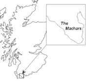
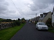
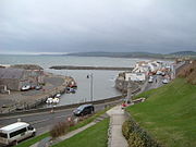
Mochrum is coastal an ceevil pairish o the Kirk o Scotland in the historical coonty o Wigtounshire in Dumfries an Gallowa, Scotland. It kivers 22,000 acre an is aboot 10 mile lang an 5 mile wide. The pairish conteens the eponymous veelage o Mochrum, as weel as Port William an the clachan o Elrig.

Read article
File:Dumfries_and_Galloway_UK_location_map.svgFile:Mochram_Village_from_the_Motte_04-11-12_03.jpegFile:Mochrum_Church_and_Churchyard_-_geograph.org.uk_-_699082.jpgFile:Chapel_Finian_-_geograph.org.uk_-_166988.jpgFile:Cave_Dwelling,_Rocks_of_the_Garheugh_-_geograph.org.uk_-_423474.jpgFile:Castle_Island,_Castle_Loch_-_geograph.org.uk_-_427786.jpgFile:The_Castle_Loch_Burn_-_geograph.org.uk_-_812519.jpgFile:Bronze_Age_cairn_on_Mochrum_Fell_-_geograph.org.uk_-_719838.jpgFile:Burial_cist_on_Mochrum_Fell_-_geograph.org.uk_-_719860.jpgFile:Old_Place_of_Mochrum.jpgFile:Mote_of_Crailloch,_Mochrum.jpgFile:Mote_of_Crailloch_(1).jpgFile:Mochrum_Fell.jpgFile:Doon_of_May_Iron_Age_Hill_Fort.jpgFile:Mote_of_Druchtag_-_geograph.org.uk_-_1752121.jpgFile:Barsalloch_Point_-_geograph.org.uk_-_214287.jpgFile:Elrig_Loch_Crannog.jpg