File:South-America_Koppen_Map.png
From Wikipedia, the free encyclopedia
Oreeginal file (1,200 × 1,821 pixels, file size: 642 KB, MIME type: image/png)
This file is fae Wikimedia Commons n micht be uised bi ither waurks. The descreeption oan its file descreeption page thaur is shawn ablo.

|
This meteorology image could be re-created using vector graphics as an SVG file. This has several advantages; see Commons:Media for cleanup for more information. If an SVG form of this image is available, please upload it and afterwards replace this template with
{{vector version available|new image name}}.
It is recommended to name the SVG file “South America Köppen Map.svg”—then the template Vector version available (or Vva) does not need the new image name parameter. |
| Peel, M. C. and Finlayson, B. L. and McMahon, T. A. (2007). "Updated world map of the Köppen-Geiger climate classification". Hydrol. Earth Syst. Sci. 11: 1633-1644. ISSN 1027-5606. | Contents |
Legend
|
|
Ootline
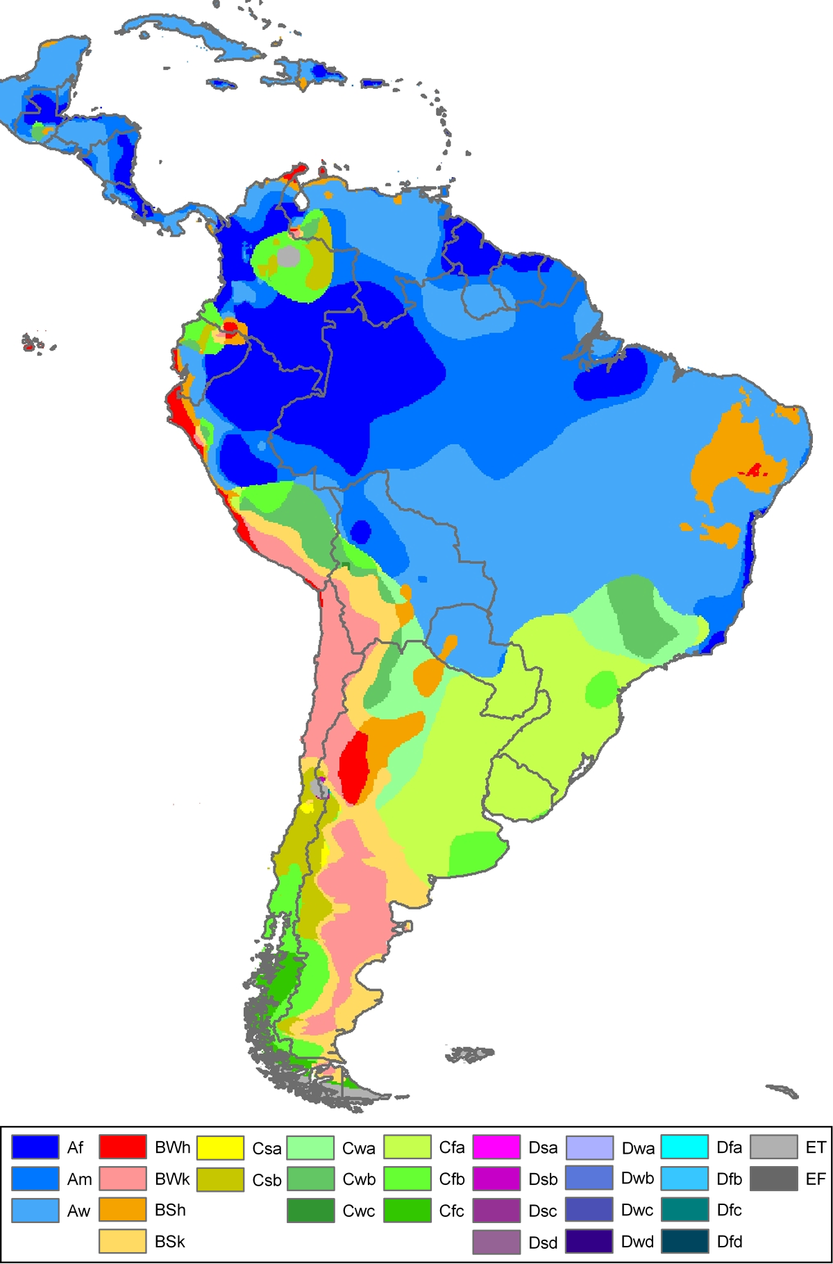
| DescreeptionSouth America Köppen Map.png | Climate map of South-America, including Central-America and the Caribbean (from the "Updated world map of the Köppen-Geiger climate classification"). | ||
| Date | |||
| Soorce | Hydrology and Earth System Sciences: "Updated world map of the Köppen-Geiger climate classification" (Supplement) - Original file was a JPG-file, this file is has been converted to a PNG-file, without extra modifications, by me (Jeroen). | ||
| Author |
Peel, M. C., Finlayson, B. L., and McMahon, T. A. (University of Melbourne) |
||
| Permission (Reuisin this file) |
|
||
| Other versions | Derivative works of this file: Brazil Köppen Climate Map.png |
Related maps
User Jeroenvrp made for these continents and areas a cropped and resized version:
- Africa Köppen Map.png
- Asia Köppen Map.png
- Australia-Oceania Köppen Map.png
- Europe Köppen Map.png
- North America Köppen Map.png
- Russia Köppen Map.png
- South America Köppen Map.png
- West Asia Köppen Map.png.
User LordToran made from the same data these maps:
- Klimagürtel-der-erde-eisklima.png
- Klimagürtel-der-erde-gemäßigte-zone.png
- Klimagürtel-der-erde-polargebiete.png
- Klimagürtel-der-erde-subtropen.png
- Klimagürtel-der-erde-tropen.png
- Klimagürtel-der-erde-tundra.png
- Klimagürtel-der-erde-warmgemäßigte-zone.png
- Klimagürtel-der-erde.png
- Klimagürtel-der-erde.svg
- Klimate-humidität.png
- Köppen-geiger-hessd-2007.svg
- Köppen-vereinfacht.svg
- Trockenklimate.png
Licensin
- Ye are free:
- tae share – tae copy, distribute an transmit the wirk
- tae remix – tae adapt the wirk
- Unner the follaein condeetions:
- attribution – Ye must attribute the wirk in the manner specified bi the author or licensor (but nae in ony way that suggests that thay endorse ye or yer uise o the wirk).
- share alik – If ye alter, transform, or big upon this wirk, ye mey distribute the resultin wirk anly unner the same or seemilar license tae this ane.
Captions
Items portrayed in this file
depicts
copyright status Inglis
copyrighted Inglis
12 October 2007
File history
Clap oan ae date/time fer tae see the file aes it kithed at that time.
| Date/Time | Thummnail | Dimensions | Uiser | Comment | |
|---|---|---|---|---|---|
| current | 13:02, 21 November 2016 | | 1,200 × 1,821 (642 KB) | Pandakekok9 | Transparent |
| 23:01, 12 October 2007 |  | 1,200 × 1,821 (560 KB) | Jeroen | Citation: '''Peel, M. C., Finlayson, B. L., and McMahon, T. A.: Updated world map of the Köppen-Geiger climate classification, Hydrol. Earth Syst. Sci., 11, 1633-1644, 2007.''' {{Information |Description= Climate map of North-America (from the "[[:Ima |
Eimage airtins
The'r nae pages airts tae this eimage.
Global file uisage
The follaein ither wikis uise this file:
- Uisage on ca.wikipedia.org
- Uisage on cs.wikipedia.org
- Uisage on eo.wikipedia.org
- Uisage on fr.wikipedia.org
- Uisage on fy.wikipedia.org
- Uisage on he.wikipedia.org
- Uisage on hi.wikipedia.org
- Uisage on ja.wikipedia.org
- Uisage on lv.wikipedia.org
- Uisage on mk.wikipedia.org
- Uisage on nl.wikipedia.org
- Uisage on pt.wikipedia.org
- Uisage on sl.wikipedia.org
- Uisage on th.wikipedia.org
- Uisage on zh.wikipedia.org
Metadata
This file contains addeetional information, likelie eikit fae the deegital camera or scanner uised tae cræft or deegitise it.
Gif the file haes bin modeefied fae its oreeginal state, some details micht na fullie reflect the modeefied file.
| Horizontal resolution | 236.22 dpc |
|---|---|
| Verteecal resolution | 236.22 dpc |