File:Mapofkanto.png
From Wikipedia, the free encyclopedia
Nae heier resolution available.
Mapofkanto.png (585 × 554 pixels, file size: 306 KB, MIME type: image/png)
This file is fae Wikimedia Commons n micht be uised bi ither waurks. The descreeption oan its file descreeption page thaur is shawn ablo.
Ootline
| DescreeptionMapofkanto.png |
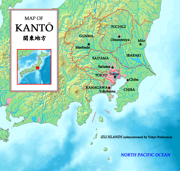
English: A map of the Kanto region in Japan with prefectures and their borders indicated. Made by the uploader. Map is based on a map taken from http://www.demis.nl/wms/mapclip.htm.
日本語: 関東地方の地図、http://www.demis.nl/wms/mapclip.htmから。 |
| Date | 1 Julie 2006 (original upload date) |
| Soorce | Made by the uploader. Map is based on a map taken from http://www.demis.nl/wms/mapclip.htm. |
| Author | No machine-readable author provided. Tonym88~commonswiki assumed (based on copyright claims). |
Licensin
I, the copyright holder of this work, hereby publish it under the following licenses:

|
Permission is grantit tae copy, distribute an/or modify this document unner the terms o the GNU Free Documentation License, Version 1.2 or ony later version published bi the Free Software Foundation; wi no Invariant Sections, no Front-Cover Texts, an no Back-Cover Texts. A copy o the license is includit in the section enteetled GNU Free Documentation License.http://www.gnu.org/copyleft/fdl.htmlGFDLGNU Free Documentation Licensetruetrue |
| This file is licensed unner the Creative Commons Attribution-Share Alike 3.0 Unported license. | ||
| ||
| This licensing tag was added to this file as part of the GFDL licensing update.http://creativecommons.org/licenses/by-sa/3.0/CC BY-SA 3.0Creative Commons Attribution-Share Alike 3.0truetrue |
This file is licensed under the Creative Commons Attribution-Share Alike 2.5 Generic, 2.0 Generic and 1.0 Generic license.
- Ye are free:
- tae share – tae copy, distribute an transmit the wirk
- tae remix – tae adapt the wirk
- Unner the follaein condeetions:
- attribution – Ye must attribute the wirk in the manner specified bi the author or licensor (but nae in ony way that suggests that thay endorse ye or yer uise o the wirk).
- share alik – If ye alter, transform, or big upon this wirk, ye mey distribute the resultin wirk anly unner the same or seemilar license tae this ane.
Ye mey select the license o yer choice.
| Public domainPublic domainfalsefalse |
This image is in the public domain because it came from the site https://www.demis.nl/products/web-map-server/examples/ and was released by the copyright holder. Permission is granted to copy, distribute and/or modify this map since it is based on free of copyright images from: www.demis.nl. See also approval email on de.wp and its clarification.
Deutsch | English | македонски | മലയാളം | Nederlands | slovenščina | +/− |
| Public domainPublic domainfalsefalse |
| This work has been released into the public domain by its copyright holder, www.demis.nl. This applies worldwide. In some countries this may not be legally possible; if so: www.demis.nl grants anyone the right to use this work for any purpose, without any conditions, unless such conditions are required by law. Public domainPublic domainfalsefalse |
Captions
Add a one-line explanation of what this file represents
Items portrayed in this file
depicts
1 Julie 2006
File history
Clap oan ae date/time fer tae see the file aes it kithed at that time.
| Date/Time | Thummnail | Dimensions | Uiser | Comment | |
|---|---|---|---|---|---|
| current | 18:39, 19 Mey 2007 | | 585 × 554 (306 KB) | Tonym88~commonswiki | New version |
| 20:24, 1 Julie 2006 |  | 627 × 581 (279 KB) | Tonym88~commonswiki | A map of the Kanto region in Japan with Prefectures and their borders indicated. Made by the uploader. Map is based on a map taken from http://www.demis.nl/wms/mapclip.htm. This is a duplicate image of Image:Kantomap.png. This image had to be create |
Eimage airtins
The follaein pages airts tae this image:
Global file uisage
The follaein ither wikis uise this file:
- Uisage on azb.wikipedia.org
- Uisage on be.wikipedia.org
- Uisage on en.wikipedia.org
- Uisage on es.wikipedia.org
- Uisage on fa.wikipedia.org
- Uisage on fr.wikipedia.org
- Uisage on gl.wikipedia.org
- Uisage on hi.wikipedia.org
- Uisage on hu.wikipedia.org
- Uisage on io.wikipedia.org
- Uisage on km.wikipedia.org
- Uisage on nl.wikipedia.org
- Uisage on nn.wikipedia.org
- Uisage on pam.wikipedia.org
- Uisage on pl.wikipedia.org
- Uisage on pt.wikipedia.org
- Uisage on ru.wikipedia.org
- Uisage on simple.wikipedia.org
- Uisage on sr.wikipedia.org
- Uisage on th.wikipedia.org
- Uisage on ur.wikipedia.org
- Uisage on vi.wikipedia.org