Dosiye:Kayangel.png
From Wikipedia, the free encyclopedia
Ingano yiri shusho:384 × 599 pixels. Indi ingano zagutse: 154 × 240 pixels | 466 × 727 pixels.
Dosiye nyirizina (466 × 727 pixels, file size: 141 KB, MIME type: image/png)
Iyi dosiye iva kuri Wikimedia Commons kandi ishobora gukoreshwa muyindi mishinga. Ubusobanuro kuri urupapuro rusobanura dosiye zayo zerekanwa aha hakurikira.
Incamake
| UmwirondoroKayangel.png |
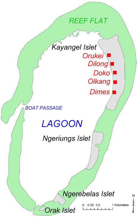
English: Map of Kayangel Atoll, Palau. Based on map from NOAA |
| Itariki | |
| Inkomoko | original source: http://ccmaserver.nos.noaa.gov/products/biogeography/Palau_IKONOS_GCPs_report.pdf (PDF) |
| Umwanditsi | NOAA, modified by Ratzer to show names of islets and villages |
Uruhushya
| Public domainPublic domainfalsefalse |
This image is in the public domain because it contains materials that originally came from the U.S. National Oceanic and Atmospheric Administration, taken or made as part of an employee's official duties.
العربية ∙ čeština ∙ Deutsch ∙ Zazaki ∙ English ∙ español ∙ eesti ∙ suomi ∙ français ∙ hrvatski ∙ magyar ∙ italiano ∙ 日本語 ∙ 한국어 ∙ македонски ∙ മലയാളം ∙ Plattdüütsch ∙ Nederlands ∙ polski ∙ português ∙ română ∙ русский ∙ sicilianu ∙ slovenščina ∙ Türkçe ∙ Tiếng Việt ∙ 简体中文 ∙ 繁體中文 ∙ +/− |
Original upload log
| date/time | username | Dimensions | File Size | edit summary |
|---|---|---|---|---|
| 06:12, 08 July 2006 | Ratzer | 466×727 | 141 KB | (new version (workover by me) |
| 15:30, 07 July 2006 | Ratzer | 466×727 | 139 KB | (version 2 - slightly worked over) |
| 10:53, 07 July 2006 | Ratzer | 466×727 | 132 KB | (Base map from http://ccmaserver.nos.noaa.gov/products/biogeography/Palau_IKONOS_GCPs_report.pdf (NOAA page -> U.S. government work) modified by me to show names of islets and villages) |
Captions
Add a one-line explanation of what this file represents
Items portrayed in this file
depicts Icyongereza
inception Icyongereza
2006
Amateka ya dosiye
Kanda kwitariki/n'isaha kugirango ufungure dosiye nkuko yagaragaye cyagihe.
| Itariki/Isaha | Ifoto ntoya | Ibipimo | Umukoresha | Comment | |
|---|---|---|---|---|---|
| muri iki gihe | 08:03, 7 Gicurasi 2009 | | 466 × 727 (141 KB) | Telim tor | == {{int:filedesc}} == {{Information |Description=Map of Kayangel Atoll, Palau. Based on map from NOAA |Source=original source: http://ccmaserver.nos.noaa.gov/products/biogeography/Palau_IKONOS_GCPs_report.pdf (PDF) |Date={{Date|2006}} |Author=NOAA, modif |
Ikoreshwa rya dosiye
Ibi bikurikira abakoresha urupapuro iyi dosiye:
Ikoreshwa rya dosiye rusange
Izindi wiki zikurikira zikoresha iyi dosiye:
- Ikoreshwa kuri ar.wikipedia.org
- Ikoreshwa kuri en.wikipedia.org
- Ikoreshwa kuri es.wikipedia.org
- Ikoreshwa kuri ja.wikipedia.org
- Ikoreshwa kuri ko.wikipedia.org
- Ikoreshwa kuri lt.wikipedia.org
- Ikoreshwa kuri mk.wikipedia.org
- Ikoreshwa kuri mrj.wikipedia.org
- Ikoreshwa kuri nl.wikipedia.org
- Ikoreshwa kuri pt.wikipedia.org
- Ikoreshwa kuri ru.wikipedia.org
- Ikoreshwa kuri uk.wikipedia.org
- Ikoreshwa kuri vi.wikipedia.org
Garura kuri "https://rw.wikipedia.org/wiki/Dosiye:Kayangel.png"