Файл:Laguna_del_Carbón_2021-08-02_Sentinel-2_L2A_True_color.jpg
Материал из Википедии — свободной encyclopedia
Исходный файл (1551 × 1582 пкс, размер файла: 490 КБ, MIME-тип: image/jpeg)
Этот файл находится на Викискладе. Сведения о нём показаны ниже.
Викисклад — централизованное хранилище для свободных файлов, используемых в проектах Викимедиа.
Сообщить об ошибке с файлом |
Краткое описание
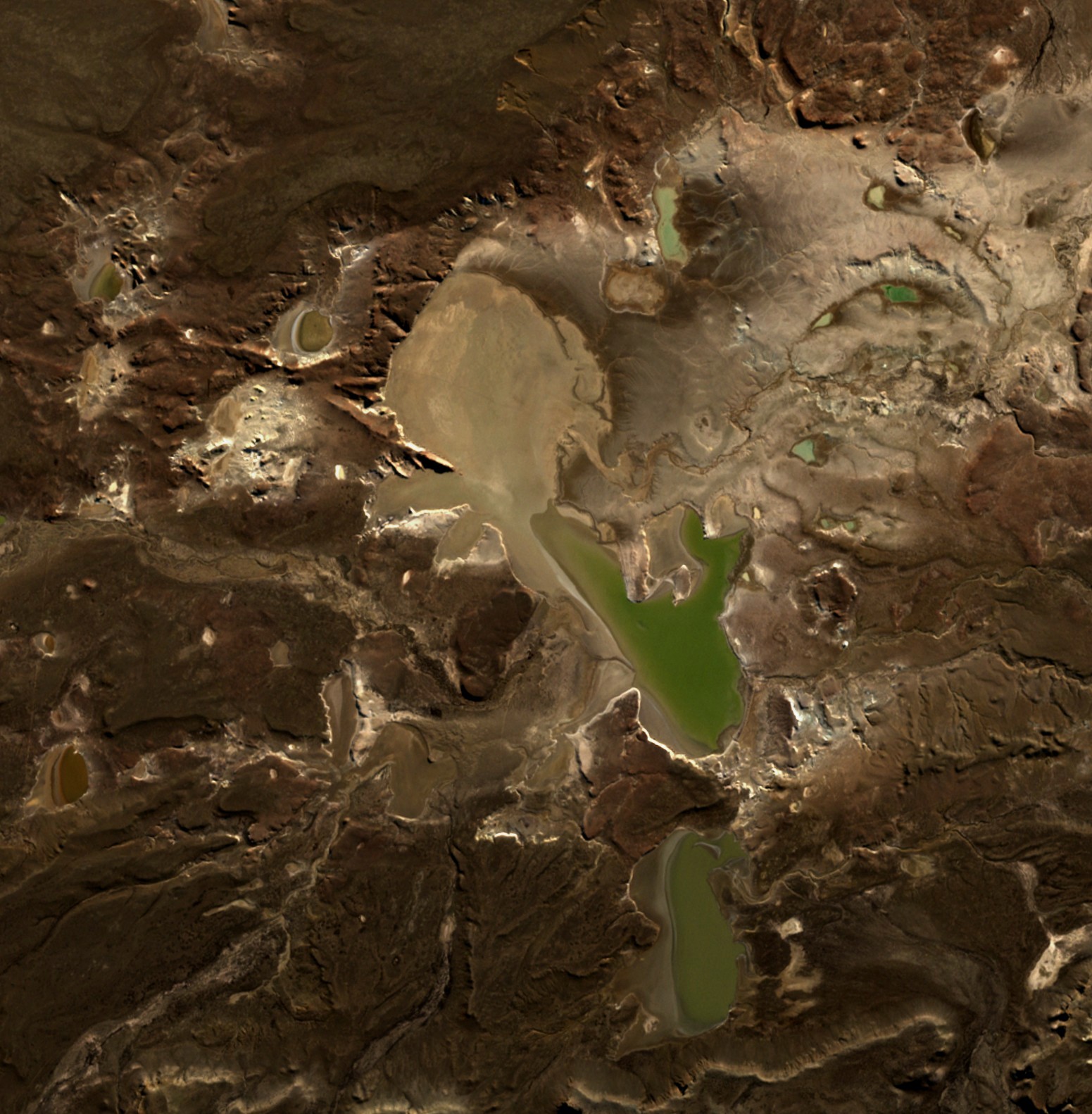
| ОписаниеLaguna del Carbón 2021-08-02 Sentinel-2 L2A True color.jpg |
English: Laguna del Carbón is the lowest point of Argentina and the Americas, and the seventh-lowest point on Earth. |
| Дата | |
| Источник | https://apps.sentinel-hub.com/eo-browser |
| Автор | European Space Agency |
| Местоположение камеры | 49° 35′ 04,24″ ю. ш., 68° 20′ 41,51″ з. д. | Это и другие изображения по их местоположению на OpenStreetMap |
|---|
Лицензирование

|
This image contains data from a satellite in the Copernicus Programme, such as Sentinel-1, Sentinel-2 or Sentinel-3. Attribution is required when using this image.
Атрибуция: Contains modified Copernicus Sentinel data 2021
Attribution
The use of Copernicus Sentinel Data is regulated under EU law (Commission Delegated Regulation (EU) No 1159/2013 and Regulation (EU) No 377/2014). Relevant excerpts:
Free access shall be given to GMES dedicated data [...] made available through GMES dissemination platforms [...].
Access to GMES dedicated data [...] shall be given for the purpose of the following use in so far as it is lawful:
GMES dedicated data [...] may be used worldwide without limitations in time.
GMES dedicated data and GMES service information are provided to users without any express or implied warranty, including as regards quality and suitability for any purpose. |
Attribution
Краткие подписи
Элементы, изображённые на этом файле
изображённый объект
2 августа 2021
49°35'4.240"S, 68°20'41.514"W
image/jpeg
История файла
Нажмите на дату/время, чтобы посмотреть файл, который был загружен в тот момент.
| Дата/время | Миниатюра | Размеры | Участник | Примечание | |
|---|---|---|---|---|---|
| текущий | 22:36, 3 мая 2022 | | 1551 × 1582 (490 КБ) | Hubert Kororo | Uploaded a work by European Space Agency from https://apps.sentinel-hub.com/eo-browser with UploadWizard |
Использование файла
Следующая страница использует этот файл:
Глобальное использование файла
Данный файл используется в следующих вики:
- Использование в bg.wikipedia.org
- Использование в ca.wikipedia.org
- Использование в ceb.wikipedia.org
- Использование в cs.wikipedia.org
- Использование в el.wikipedia.org
- Использование в en.wikipedia.org
- Использование в eo.wikipedia.org
- Использование в es.wikipedia.org
- Использование в eu.wikipedia.org
- Использование в fr.wikipedia.org
- Использование в pl.wikipedia.org
- Использование в sr.wikipedia.org
- Использование в uk.wikipedia.org
- Использование в www.wikidata.org
- Использование в zh-yue.wikipedia.org