Файл:Cyprus_districts_named.png
Материал из Википедии — свободной encyclopedia
Нет версии с бо́льшим разрешением.
Cyprus_districts_named.png (600 × 365 пкс, размер файла: 22 КБ, MIME-тип: image/png)
Этот файл находится на Викискладе. Сведения о нём показаны ниже.
Викисклад — централизованное хранилище для свободных файлов, используемых в проектах Викимедиа.
Сообщить об ошибке с файлом |

|
Эту карту желательно воссоздать или аккуратно преобразовать в векторный формат SVG. Это даёт несколько преимуществ, прочитать о которых подробнее вы можете на странице Commons:Media for cleanup. Если вам уже сейчас доступна векторная версия данного изображения, загрузите её, пожалуйста, а затем замените этот шаблон на следующий: {{Vector version available|Имя загруженного файла.svg}}.
|
Краткое описание
| ОписаниеCyprus districts named.png |
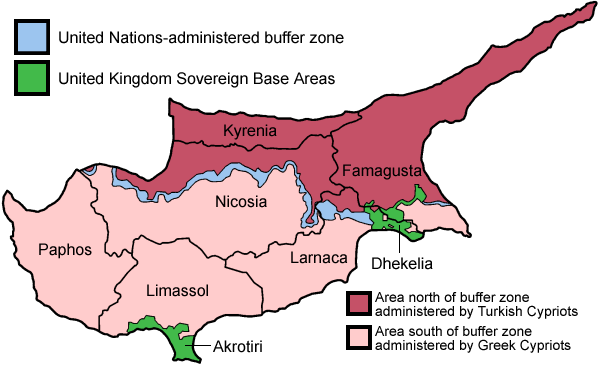
English: Map of the districts of Cyprus, named in English, with English annotations, and showing the Turkish Republic of Northern Cyprus, United Kingdom Sovereign Base Areas, and United Nations buffer zone. The individual maps see below.
Deutsch: Karte der Distrikte Zyperns: Bezirke der Republik Zypern, Türkische Republik Nordzypern, UK-Militärbasen, UN-Pufferzone (englische Beschriftung). Zu den Einzelkarten siehe unten "Individual maps". |
| Дата | |
| Источник | Собственная работа (traced from public domain UN or CIA maps.) |
| Автор | Golbez |
| Другие версии |
Français : File:Carte des districts de Chypre.png
Ελληνικά: File:Cyprus districts named el.png
|
Лицензирование
Я, владелец авторских прав на это произведение, добровольно публикую его на условиях следующих лицензий:
Этот файл доступен на условиях лицензий Creative Commons Attribution-Share Alike 2.5 Generic, 2.0 Generic и 1.0 Generic.
- Вы можете свободно:
- делиться произведением – копировать, распространять и передавать данное произведение
- создавать производные – переделывать данное произведение
- При соблюдении следующих условий:
- атрибуция – Вы должны указать авторство, предоставить ссылку на лицензию и указать, внёс ли автор какие-либо изменения. Это можно сделать любым разумным способом, но не создавая впечатление, что лицензиат поддерживает вас или использование вами данного произведения.
- распространение на тех же условиях – Если вы изменяете, преобразуете или создаёте иное произведение на основе данного, то обязаны использовать лицензию исходного произведения или лицензию, совместимую с исходной.

|
Разрешается копировать, распространять и/или изменять этот документ в соответствии с условиями GNU Free Documentation License версии 1.2 или более поздней, опубликованной Фондом свободного программного обеспечения, без неизменяемых разделов, без текстов, помещаемых на первой и последней обложке. Копия лицензии включена в раздел, озаглавленный GNU Free Documentation License.http://www.gnu.org/copyleft/fdl.htmlGFDLGNU Free Documentation Licensetruetrue |
| Этот файл доступен по лицензии Creative Commons Attribution-Share Alike 3.0 Unported. | ||
| ||
| Этот признак лицензирования был добавлен к этому файлу как часть обновления лицензии GFDL.http://creativecommons.org/licenses/by-sa/3.0/CC BY-SA 3.0Creative Commons Attribution-Share Alike 3.0truetrue |
Вы можете выбрать любую из этих лицензий.
Individual maps of the Cyprus districts
Краткие подписи
Добавьте однострочное описание того, что собой представляет этот файл
Map with the island of Cyprus split into different administrative sections. (see legend)
A Ciprusi Köztársaság közigazgatási kerületei
Χάρτης του νησιού της Κύπρου διαχωρισμένο σε διαφορετικά διοικητικά τμήματα. (βλέπε υπόμνημα)
خريطة توضح مقاطعات قبرص باللغة الإنجليزية، وتظهر جمهورية قبرص، وجمهورية شمال قبرص التركية، ومناطق القواعد السيادية التابعة للمملكة المتحدة، والمنطقة العازلة الخاضعة لسيطرة الأمم المتحدة.
Элементы, изображённые на этом файле
изображённый объект
У этого свойства есть некоторое значение без элемента в
image/png
2c30cef6aae2d3de01805aa236f469a70a50ee08
22 511 байт
365 пиксель
600 пиксель
История файла
Нажмите на дату/время, чтобы посмотреть файл, который был загружен в тот момент.
| Дата/время | Миниатюра | Размеры | Участник | Примечание | |
|---|---|---|---|---|---|
| текущий | 20:38, 30 мая 2010 | | 600 × 365 (22 КБ) | Wknight94 | Reverted to version as of 14:28, 13 August 2007 ---- latest upload with no new info on source, etc. |
| 23:46, 17 ноября 2008 |  | 700 × 482 (94 КБ) | Guntars strazdins | {{Information |Description= |Source= |Date= |Author= |Permission= |other_versions= }} | |
| 23:44, 17 ноября 2008 |  | 700 × 482 (94 КБ) | Guntars strazdins | {{Information |Description= |Source= |Date= |Author= |Permission= |other_versions= }} | |
| 14:28, 13 августа 2007 |  | 600 × 365 (22 КБ) | Lexicon | Reverted to earlier revision | |
| 14:28, 13 августа 2007 |  | 600 × 365 (54 КБ) | Lexicon | buffer zone and SBA colours flipped, since buffer zone is called the "Green Line" | |
| 06:07, 30 июня 2005 |  | 600 × 365 (22 КБ) | Golbez | Got Dhekelia wrong again. Final version unless others have comments. | |
| 02:04, 28 июня 2005 |  | 600 × 365 (22 КБ) | Golbez | Updated again, final version for now, cleaned up text and the Dhekelia area. | |
| 17:51, 27 июня 2005 |  | 600 × 365 (20 КБ) | Golbez | Fixed a color | |
| 17:44, 27 июня 2005 |  | 600 × 365 (20 КБ) | Golbez | Updated map with different color for north and south, and enclaves in Dhekelia. | |
| 09:48, 27 июня 2005 |  | 600 × 365 (19 КБ) | Golbez | Map of the districts of Cyprus Source: Made by User:Golbez. {{cc-by-sa-2.0}} Category:Maps of Cyprus\ |
Использование файла
Следующие 5 страниц используют этот файл:
Глобальное использование файла
Данный файл используется в следующих вики:
- Использование в af.wikipedia.org
- Использование в ar.wikipedia.org
- Использование в arz.wikipedia.org
- Использование в az.wikipedia.org
- Использование в az.wiktionary.org
- Использование в be.wikipedia.org
- Использование в bs.wikipedia.org
- Использование в ca.wikipedia.org
- Conflicte de Xipre
- Resolució 187 del Consell de Seguretat de les Nacions Unides
- Resolució 192 del Consell de Seguretat de les Nacions Unides
- Resolució 193 del Consell de Seguretat de les Nacions Unides
- Resolució 194 del Consell de Seguretat de les Nacions Unides
- Resolució 198 del Consell de Seguretat de les Nacions Unides
- Resolució 201 del Consell de Seguretat de les Nacions Unides
- Resolució 206 del Consell de Seguretat de les Nacions Unides
- Resolució 207 del Consell de Seguretat de les Nacions Unides
- Resolució 219 del Consell de Seguretat de les Nacions Unides
- Resolució 220 del Consell de Seguretat de les Nacions Unides
- Resolució 222 del Consell de Seguretat de les Nacions Unides
- Resolució 231 del Consell de Seguretat de les Nacions Unides
- Resolució 244 del Consell de Seguretat de les Nacions Unides
- Resolució 254 del Consell de Seguretat de les Nacions Unides
- Resolució 266 del Consell de Seguretat de les Nacions Unides
- Resolució 274 del Consell de Seguretat de les Nacions Unides
- Força de les Nacions Unides pel Manteniment de la Pau a Xipre
- Resolució 293 del Consell de Seguretat de les Nacions Unides
- Resolució 305 del Consell de Seguretat de les Nacions Unides
- Resolució 315 del Consell de Seguretat de les Nacions Unides
- Resolució 324 del Consell de Seguretat de les Nacions Unides
- Resolució 334 del Consell de Seguretat de les Nacions Unides
- Resolució 343 del Consell de Seguretat de les Nacions Unides
- Resolució 349 del Consell de Seguretat de les Nacions Unides
- Resolució 358 del Consell de Seguretat de les Nacions Unides
- Resolució 360 del Consell de Seguretat de les Nacions Unides
- Resolució 361 del Consell de Seguretat de les Nacions Unides
- Resolució 364 del Consell de Seguretat de les Nacions Unides
- Resolució 365 del Consell de Seguretat de les Nacions Unides
- Línia Verda (Xipre)
- Resolució 593 del Consell de Seguretat de les Nacions Unides
- Resolució 716 del Consell de Seguretat de les Nacions Unides
- Resolució 774 del Consell de Seguretat de les Nacions Unides
- Resolució 969 del Consell de Seguretat de les Nacions Unides
- Resolució 1475 del Consell de Seguretat de les Nacions Unides
- Resolució 1517 del Consell de Seguretat de les Nacions Unides
- Использование в ckb.wikipedia.org
Просмотреть глобальное использование этого файла.