File:Map_of_Chester_County_Pennsylvania_With_Municipal_and_Township_Labels.png
De Wikipedia, a enciclopédia encyclopedia
Sem resolução maior disponível.
Map_of_Chester_County_Pennsylvania_With_Municipal_and_Township_Labels.png (637 × 566 píxeis, tamanho: 80 kB, tipo MIME: image/png)
|
|
Esta imagem provém do Wikimedia Commons, um acervo de conteúdo livre da Wikimedia Foundation que pode ser utilizado por outros projetos.
|


Descrição do ficheiro
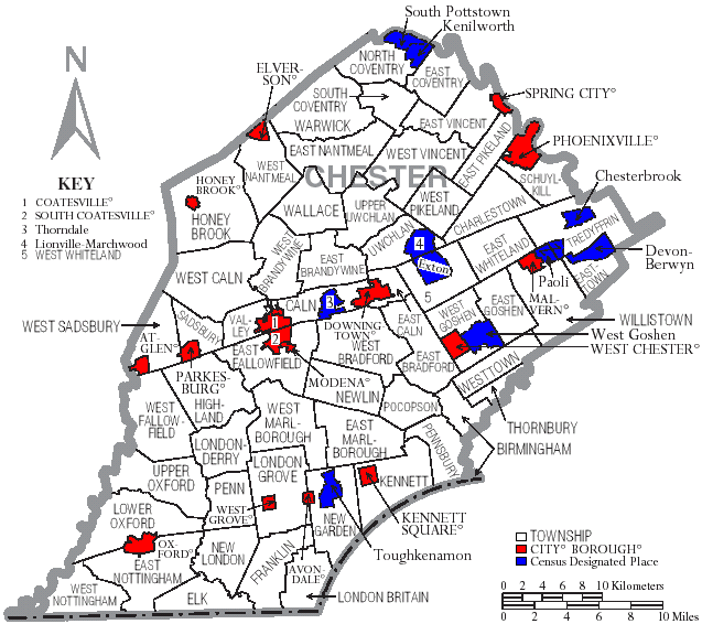
| DescriçãoMap of Chester County Pennsylvania With Municipal and Township Labels.png | Map of Chester County, Pennsylvania, United States with township and municipal boundaries |
| Data | |
| Origem | taken from US Census website [1] and modified by User:Ruhrfisch |
| Autor | US Census, Ruhrfisch |
| Permissão (Reutilizar este ficheiro) |
US Census / US Government work is public domain, my modifications licensed under the GNU Free Documentation License |
Licenciamento

|
É concedida permissão para copiar, distribuir e/ou modificar este documento nos termos da Licença de Documentação Livre GNU, versão 1.2 ou qualquer versão posterior publicada pela Free Software Foundation; sem Secções Invariantes, sem textos de Capa e sem textos de Contra-Capa. É incluída uma cópia da licença na secção intitulada GNU Free Documentation License.http://www.gnu.org/copyleft/fdl.htmlGFDLGNU Free Documentation Licensetruetrue |
| A utilização deste ficheiro é regulada nos termos da licença Creative Commons - Atribuição-CompartilhaIgual 3.0 Não Adaptada. | ||
| ||
| Esta marca de licenciamento foi adicionada a este ficheiro durante a atualização da licença GFDL.http://creativecommons.org/licenses/by-sa/3.0/CC BY-SA 3.0Creative Commons Attribution-Share Alike 3.0truetrue |
Legendas
Adicione uma explicação de uma linha do que este ficheiro representa
Elementos retratados neste ficheiro
retrata
abril 2006
Histórico do ficheiro
Clique uma data e hora para ver o ficheiro tal como ele se encontrava nessa altura.
| Data e hora | Miniatura | Dimensões | Utilizador | Comentário | |
|---|---|---|---|---|---|
| atual | 15h02min de 13 de setembro de 2008 | | 637 × 566 (80 kB) | Ruhrfisch | Cleanup, all other information the same |
| 20h54min de 18 de abril de 2006 |  | 637 × 566 (82 kB) | Ruhrfisch | {{Information| |Description= Map of Chester County, Pennsylvania, United States with township and municipal boundaries |Source= taken from US Census website [http://www2.census.gov/geo/maps/general_ref/cousub_outline/cen2k_pgsz/pa_cosub.pdf] and modified |
Utilização local do ficheiro
A seguinte página usa este ficheiro:
Utilização global do ficheiro
As seguintes wikis usam este ficheiro:
- de.wikipedia.org
- en.wikipedia.org
- eo.wikipedia.org
- es.wikipedia.org
- frr.wikipedia.org
- it.wikipedia.org
- ja.wikipedia.org
- kw.wikipedia.org
- nl.wikipedia.org
- pl.wikipedia.org