File:Italy_1494_AD-it.svg
De Wikipedia, a enciclopédia encyclopedia

Imagem numa resolução maior (ficheiro SVG, de 688 × 930 píxeis, tamanho: 418 kB)
|
|
Esta imagem provém do Wikimedia Commons, um acervo de conteúdo livre da Wikimedia Foundation que pode ser utilizado por outros projetos.
|
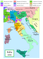
A exactidão factual deste mapa é contestada.
Motivo: This map and its derivatives need correction and update, as it is mostly based on the Shepherd's map which shows innacurate history of Venetian Republic on Eastern Adriatic, specifically of Dalmatia. It is showing seriouly erroneous and misleading Venetian control over whole region of modern Dalmatia - which became in full extent only in the late 17th and 18th century. It was never the case in the 15th and 16th century, as then most part of Dalmatian hinterland was under Hungarian-Croatian Kingdom and then Ottoman Empire. Venetian Dalmatia at the time included only the very coastal part of Dalmatia with very near hinterland of the Dalmatian city-states, the majority of the hinterland was not Venetian at all. The borders of the Ottoman conquest are also significantly erroneous for the time period as in the map look like modern borders of Bosnia and Herzegovina which became the case only many centuries later. |  |
Descrição do ficheiro
Political map of Italy in early 1494, before the invasion of Italy by Charles VIII of France, created by MapMaster.
This is a companion map to Image:Italy 1000 AD.svg, Image:Italy 1796.png, and Image:Italy c 1810.png.
Este mapa está melhor ou existe através dos Wikigráficos do Laboratório Gráfico (it). Você também pode propor imagens para serem limpas, melhoradas, criadas ou traduzidas. |
Este ficheiro SVG contém texto integrado que pode ser traduzido para a sua língua, usando um editor que possa suportar SVG (como XML ou texto). Para mais informações, consulte: Sobre a tradução de ficheiros SVG. |
Versions
[editar]
PNG:
-
 árabe
árabe -
 inglês
 -
 grego
grego


SVG:
-
 catalão
 -
 espanhol
 -
 francês
 -
 italiano
 -
 húngaro


See similar versions (disputed too): Map of Italy (1494)
References
- Bjorklund, Oddvar; Holmboe, Haakon; Rohr, Anders (1970) Historical Atlas of the World, Barnes & Noble, NY, SBN: 389-00253-4.
- Matthew, Donald, (1983), Atlas of Medieval Europe, Checkmark Books, New York.
- Online maps, including this 1882 map from Shepherd (the University of Texas)
- this one from A B Longman, textbook publisher.
Licenciamento

|
É concedida permissão para copiar, distribuir e/ou modificar este documento nos termos da Licença de Documentação Livre GNU, versão 1.2 ou qualquer versão posterior publicada pela Free Software Foundation; sem Secções Invariantes, sem textos de Capa e sem textos de Contra-Capa. É incluída uma cópia da licença na secção intitulada GNU Free Documentation License.http://www.gnu.org/copyleft/fdl.htmlGFDLGNU Free Documentation Licensetruetrue |
| A utilização deste ficheiro é regulada nos termos da licença Creative Commons - Atribuição-CompartilhaIgual 3.0 Não Adaptada. | ||
| ||
| Esta marca de licenciamento foi adicionada a este ficheiro durante a atualização da licença GFDL.http://creativecommons.org/licenses/by-sa/3.0/CC BY-SA 3.0Creative Commons Attribution-Share Alike 3.0truetrue |
- Pode:
- partilhar – copiar, distribuir e transmitir a obra
- recombinar – criar obras derivadas
- De acordo com as seguintes condições:
- atribuição – Tem de fazer a devida atribuição da autoria, fornecer uma hiperligação para a licença e indicar se foram feitas alterações. Pode fazê-lo de qualquer forma razoável, mas não de forma a sugerir que o licenciador o apoia ou subscreve o seu uso da obra.
- partilha nos termos da mesma licença – Se remisturar, transformar ou ampliar o conteúdo, tem de distribuir as suas contribuições com a mesma licença ou uma licença compatível com a original.
derivative works
Obras derivadas deste ficheiro: Italy 1494 AD-fr.svg
Legendas
Elementos retratados neste ficheiro
retrata
Histórico do ficheiro
Clique uma data e hora para ver o ficheiro tal como ele se encontrava nessa altura.
| Data e hora | Miniatura | Dimensões | Utilizador | Comentário | |
|---|---|---|---|---|---|
| atual | 18h27min de 28 de junho de 2013 | | 688 × 930 (418 kB) | Fulvio314 | Legenda, added small territories |
| 20h46min de 26 de maio de 2013 |  | 576 × 812 (417 kB) | Fulvio314 | Font | |
| 15h31min de 27 de fevereiro de 2007 |  | 567 × 812 (1,17 MB) | MapMaster | Some modifications based on feedback from User:Paolo da Reggio | |
| 03h31min de 23 de fevereiro de 2007 |  | 567 × 812 (1,17 MB) | MapMaster | Italia, 1494. |
Utilização local do ficheiro
Não há nenhuma página que use este ficheiro.
Utilização global do ficheiro
As seguintes wikis usam este ficheiro:
- ar.wikipedia.org
- ast.wikipedia.org
- bg.wikipedia.org
- br.wikipedia.org
- el.wikipedia.org
- en.wikipedia.org
- eo.wikipedia.org
- eu.wikipedia.org
- fi.wikipedia.org
- fr.wikipedia.org
- hu.wikipedia.org
- it.wikipedia.org
- it.wikiquote.org
- ja.wikipedia.org
- ko.wikipedia.org
- la.wikipedia.org
- nn.wikipedia.org
- ru.wikipedia.org
- uk.wikipedia.org
- www.wikidata.org
- zh.wikipedia.org
Metadados
Este ficheiro contém informação adicional, provavelmente adicionada a partir da câmara digital ou scanner utilizada para criar ou digitalizar a imagem. Caso o ficheiro tenha sido modificado a partir do seu estado original, alguns detalhes poderão não refletir completamente as mudanças efetuadas.
| Largura | 688.25183 |
|---|---|
| Altura | 929.9646 |