Ficheiro:Europe_1867_map_en.png
De Wikipedia, a enciclopédia encyclopedia
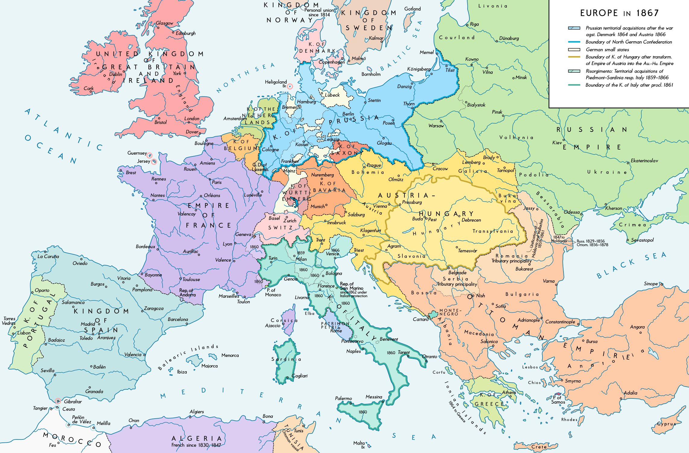
Imagem numa resolução maior (2 284 × 1 503 píxeis, tamanho: 1,07 MB, tipo MIME: image/png)
|
|
Esta imagem provém do Wikimedia Commons, um acervo de conteúdo livre da Wikimedia Foundation que pode ser utilizado por outros projetos.
|
Descrição do ficheiro
| DescriçãoEurope 1867 map en.png |
English: Europe 1867. Historical map of the political situation after the forming of the North German Confederation, the Italian Risorgimento (with the exception of the Roman part of the Papal States) and the Austro-Hungarian Compromise of 1867. Please don't alter the map, when you think there something not written or depicted correctly. Leave a message at the talk page of the file. After a verificiation and a possible discussion, i will upload a new map version with all new changes. This prevents an unnecessary waste of disc space and ensures a good result, aesthetically and contentwise. - The author. Deutsch: Europa 1867. Historische Karte der politischen Situation in Europa nach der Gründung des Norddeutschen Bundes, des italienischen Risorgimento (mit Ausnahme des röm. Teils des Kirchenstaats) und dem Österreichisch-Ungarischen Ausgleich von 1867. Bitte die Karte bei Änderungs- und Korrekturwünschen nicht selbst verändern, sondern eine Anmerkung im Diskussionsbereich der Bilddatei hinterlassen. Nach einer Prüfung und ggfs. Diskussion werden evtl. Änderungen von mir zusammengefasst eingearbeitet. Das vermeidet unnötige Speicherplatz-Verschwendung und gewährleistet ein ästhetisch ansprechendes und inhaltlich korrektes Ergebnis. - Der Urheber. |
| Data | |
| Origem |
Obra do próprio. Source of Information: Historical atlases and maps – Ramsay Muir, George Philip (ed.): Philip's New School Atlas of Universal History, George Philip & Son, Ltd., London 1928 – Dr. Walter Leisering (ed.): Putzger Historischer Weltatlas, Cornelsen Verlag, Berlin 1992, ISBN 3-464-00176-8 – Bayerischer Schulbuch-Verlag (ed.): Großer Historischer Weltatlas, Dritter Teil, Neuzeit, Bayerischer Schulbuch-Verlag, München 1981, ISBN 3-7627-6021-7. – Prof. Dr. Vadim Oswalt u. Prof. Dr. Hans Ulrich Rudolf (ed.): Klett-Perthes Atlas zur Weltgeschichte, Ernst Klett Verlag, Stuttgart 2011, ISBN 978-3-12-828194-0 – Ziegelbrenner: Karte des Norddeutschen Bundes 1866–1871, 6 June 2014 version (map link) Other publications – Francesco Traniello u. Gianni Sofri: Der lange Weg zur Nation. Das italienische Risorgimento, Verlag W. Kohlhammer, Stuttgart 2012, ISBN 978-3-17-021898-7 |
| Autor | Alexander Altenhof |
| Outras versões |
|

Recompressed without quality loss with OptiPNG (1.35 MB > 1.06 MB)
Licenciamento
- Pode:
- partilhar – copiar, distribuir e transmitir a obra
- recombinar – criar obras derivadas
- De acordo com as seguintes condições:
- atribuição – Tem de fazer a devida atribuição da autoria, fornecer uma hiperligação para a licença e indicar se foram feitas alterações. Pode fazê-lo de qualquer forma razoável, mas não de forma a sugerir que o licenciador o apoia ou subscreve o seu uso da obra.
- partilha nos termos da mesma licença – Se remisturar, transformar ou ampliar o conteúdo, tem de distribuir as suas contribuições com a mesma licença ou uma licença compatível com a original.
Legendas
Elementos retratados neste ficheiro
retrata
Um valor sem um elemento no repositório Wikidata
4 setembro 2016
Histórico do ficheiro
Clique uma data e hora para ver o ficheiro tal como ele se encontrava nessa altura.
| Data e hora | Miniatura | Dimensões | Utilizador | Comentário | |
|---|---|---|---|---|---|
| atual | 23h42min de 14 de abril de 2017 | | 2 284 × 1 503 (1,07 MB) | KaterBegemot | Empire of France (not Kingdom), changed main caption to "Europe in 1867", fixed font size of "Piedmont-Sardinia", minor changes |
| 21h36min de 4 de setembro de 2016 |  | 2 284 × 1 503 (1,06 MB) | KaterBegemot | {{Information |Description ={{en|1=Europe 1867. Historical map of the political situation after the forming of the North German Confederation, the Italian Risorgimento (with the exception of the Roman part of the Papal States) and the Austro-Hungari... |
Utilização local do ficheiro
Não há nenhuma página que use este ficheiro.
Utilização global do ficheiro
As seguintes wikis usam este ficheiro:
- ast.wikipedia.org
- en.wikipedia.org
- et.wikipedia.org
- it.wikipedia.org
Metadados
Este ficheiro contém informação adicional, provavelmente adicionada a partir da câmara digital ou scanner utilizada para criar ou digitalizar a imagem. Caso o ficheiro tenha sido modificado a partir do seu estado original, alguns detalhes poderão não refletir completamente as mudanças efetuadas.
| Resolução horizontal | 70 ppp |
|---|---|
| Resolução vertical | 70 ppp |
| Espaço de cores | Cor não calibrada |
| Largura da imagem | 2 284 px |
| Altura da imagem | 1 503 px |
| Software utilizado | Adobe Photoshop CC 2017 (Windows) |
| Data e hora de digitalização | 03h05min de 15 de abril de 2017 |
| Data e hora de modificação do ficheiro | 03h22min de 15 de abril de 2017 |
| Data da última modificação dos metadados | 03h22min de 15 de abril de 2017 |
| Identificação exclusiva do documento original | xmp.did:fd41fa5f-5199-fd40-bec6-d1a7668cc651 |