Found in articles
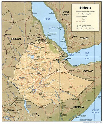
Ficheiro:Ethiopia shaded relief map 1999, CIA.jpg
DescriptionEthiopia shaded relief map 1999, CIA.jpg Shaded relief map of Ethiopia, 1999, produced by the U.S. Central Intelligence Agency. Date 1999 Source
Ficheiro:ET Gondar asv2018-02 img42 Debre Berhan Selassie.jpg
English Monastery of Debre Berhan Selassie in Gondar, Ethiopia
Ficheiro:ET Bahir Dar asv2018-02 img17 Tis Issat.jpg
English Blue Nile Falls at Tis Issat near Bahir Dar, Ethiopia Japanese 青ナイル:滝(エチオピア)
Ficheiro:ET Afar asv2018-01 img48 Dallol.jpg
landscape covered in brown iron oxide and yellow sulphur in the Afar Region of Ethiopia. Central Kurdish دەورووبەری گڕکانی دالۆل لە ناوچەی ئافەر، ئیتیۆپیا.
Ficheiro:Washare from the Hamer tribe in Logara, near Turmi, Omo Valley, Ethiopia (16882803797).jpg
Attribution 2.0 truetrue 28 April 2018 English Hamar woman of Southwestern Ethiopia French Les Hamers sont des habitants d'Afrique de l'Est vivant dans le
