دوتنه:Nangarhar_districts.png
From Wikipedia, the free encyclopedia
د همدې ليدنې کچه: ۷۸۶ × ۶۰۰ پېکسل. نورې ژورليدنې: ۳۱۵ × ۲۴۰ پېکسل | ۶۲۹ × ۴۸۰ پېکسل | ۱٬۰۰۰ × ۷۶۳ پېکسل.
اصلي دوتنه (۱٬۰۰۰ × ۷۶۳ پېکسل, د دوتنې کچه: ۴۳ کيلوبايټ, MIME بڼه: image/png)
دا دوتنه د ويکيمېډيا کامنز لخوا خپرېږې او کېدای شي چې دا په نورو پروژو هم کارېدلې وي. د دوتنې د کارېدنې لا نور مالومات د دوتنې د څرگندنو په مخ کې لاندې ښودل شوی.

|
This map image could be re-created using vector graphics as an SVG file. This has several advantages; see Commons:Media for cleanup for more information. If an SVG form of this image is available, please upload it and afterwards replace this template with
{{vector version available|new image name}}.
It is recommended to name the SVG file “Nangarhar districts.svg”—then the template Vector version available (or Vva) does not need the new image name parameter. |
لنډيز
| څرگندونهNangarhar districts.png |
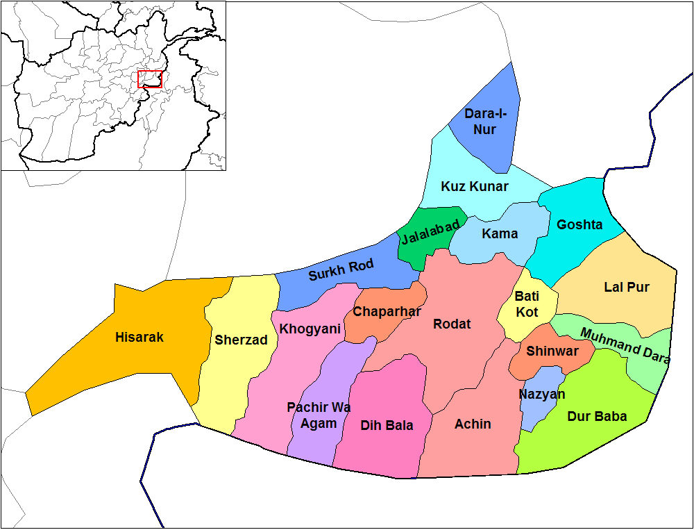
English: Map of the districts of Nangarhar province of Afghanistan. Created by Rarelibra 19:29, 29 March 2007 (UTC) for public domain use, using MapInfo Professional v8.5 and various mapping resources. |
| نېټه | ۲۹ مارچ ۲۰۰۷ (original upload date) |
| سرچينه | No machine-readable source provided. Own work assumed (based on copyright claims). |
| ليکوال | No machine-readable author provided. Rarelibra assumed (based on copyright claims). |
منښتليک:
| Public domainPublic domainfalsefalse |
| I, the copyright holder of this work, release this work into the public domain. This applies worldwide. In some countries this may not be legally possible; if so: I grant anyone the right to use this work for any purpose, without any conditions, unless such conditions are required by law. |
Captions
Add a one-line explanation of what this file represents
Items portrayed in this file
depicts انګليسي
۲۹ مارچ 2007
media type انګليسي
image/png
د دوتنې پېښليک
په يوې نېټې/يوه وخت وټوکۍ چې د هماغه وخت او نېټې دوتنه چې څنگه ښکارېده هماغسې درښکاره شي.
| نېټه/وخت | بټنوک | ډډې | کارن | تبصره | |
|---|---|---|---|---|---|
| اوسنی | ۱۴:۳۲, ۱۵ فبروري ۲۰۲۴ | | ۱٬۰۰۰ × ۷۶۳ (۴۳ کيلوبايټ) | User-duck | Cropped 5 % horizontally, 6 % vertically using CropTool with lossless mode. |
| ۱۴:۳۱, ۱۵ فبروري ۲۰۲۴ |  | ۱٬۰۵۶ × ۸۱۶ (۴۳ کيلوبايټ) | User-duck | Reverted to version as of 19:29, 29 March 2007 (UTC)recrop | |
| ۱۹:۱۱, ۱۴ فبروري ۲۰۲۴ |  | ۱٬۰۰۰ × ۷۶۰ (۴۳ کيلوبايټ) | User-duck | Cropped 5 % horizontally, 7 % vertically using CropTool with lossless mode. | |
| ۱۹:۲۹, ۲۹ مارچ ۲۰۰۷ |  | ۱٬۰۵۶ × ۸۱۶ (۴۳ کيلوبايټ) | Rarelibra | Map of the districts of Nangarhar province of Afghanistan. Created by ~~~~ for public domain use, using MapInfo Professional v8.5 and various mapping resources. |
د دوتنې کارېدنه
دا 4 لانديني مخونه د همدې دوتنې سره تړنې لري:
د نړېوالې دوتنې کارېدنه
همدا دوتنه لاندينۍ نورې ويکي گانې کاروي:
- په ar.wikipedia.org کارونې
- په bn.wikipedia.org کارونې
- په ca.wikipedia.org کارونې
- په cs.wikipedia.org کارونې
- په de.wikipedia.org کارونې
- په en.wikipedia.org کارونې
- Nangarhar Province
- Districts of Afghanistan
- Haji Ghalib
- Achin District
- Bati Kot District
- Chaparhar District
- Darai Nur District
- Dur Baba District
- Goshta District
- Hesarak District
- Kama District
- Khogyani District
- Kuz Kunar District
- Lal Pur District
- Momand Dara District
- Nazyan District
- Pachir Aw Agam District
- Rodat District
- Sherzad District
- User talk:Rarelibra/Maps1
- Haska Meyna District
- Khogyani (Pashtun tribe)
- Kot District
- Haska Meyna
- Battle of Tora Bora (2017)
د دې دوتنې نورې نړېوالې کارېدنې کتل.
مېټاډاټا
همدا دوتنه نور اضافه مالومات هم لري، چې کېدای شي ستاسې د گڼياليزې کامرې او يا هم د ځيرڅار په کارولو سره د گڼيالېدنې په وخت کې ورسره مل شوي.
که همدا دوتنه د خپل آرني دريځ څخه بدله شوې وي نو ځينې تفصيلونه به په بدل شوي دوتنه کې په بشپړه توگه نه وي.
| ليکوال | |
|---|---|
| د PNG دوتنې تبصره | |
| د رښتو خاوند | |
| انځور سرليک | |
| ردادعاليک | |
| د کامرې ماډل | |
| لنډ سرليک | |
| څنډيز ژورليد | ۳۷٫۸ dpc |
| ولاړيز ژورليد | ۳۷٫۸ dpc |
| د دوتنې د بدلون وخت او نېټه | ۱۴:۳۲, ۱۵ فبروري ۲۰۲۴ |
| د گڼياليزېدنې وخت او نېټه |
|
| کارېدلې ساوترۍ | |
| د منځپانګي خبرداری |
"https://ps.wikipedia.org/wiki/دوتنه:Nangarhar_districts.png" نه اخيستل شوی