File:EU_OCT_and_OMR_map.png
From Wikipedia, the free encyclopedia
د همدې ليدنې کچه: ۸۰۰ × ۴۰۳ پېکسل. نورې ژورليدنې: ۳۲۰ × ۱۶۱ پېکسل | ۶۴۰ × ۳۲۲ پېکسل | ۱٬۰۲۴ × ۵۱۶ پېکسل | ۱٬۲۸۰ × ۶۴۵ پېکسل | ۲٬۵۶۰ × ۱٬۲۹۰ پېکسل | ۷٬۰۰۰ × ۳٬۵۲۶ پېکسل.
اصلي دوتنه (۷٬۰۰۰ × ۳٬۵۲۶ پېکسل, د دوتنې کچه: ۳٫۲۲ مېگابايټ, MIME بڼه: image/png)
دا دوتنه د ويکيمېډيا کامنز لخوا خپرېږې او کېدای شي چې دا په نورو پروژو هم کارېدلې وي. د دوتنې د کارېدنې لا نور مالومات د دوتنې د څرگندنو په مخ کې لاندې ښودل شوی.

|
This map of the world image could be re-created using vector graphics as an SVG file. This has several advantages; see Commons:Media for cleanup for more information. If an SVG form of this image is available, please upload it and afterwards replace this template with
{{vector version available|new image name}}.
It is recommended to name the SVG file “EU OCT and OMR map.svg”—then the template Vector version available (or Vva) does not need the new image name parameter. |
لنډيز
| څرگندونهEU OCT and OMR map.png |
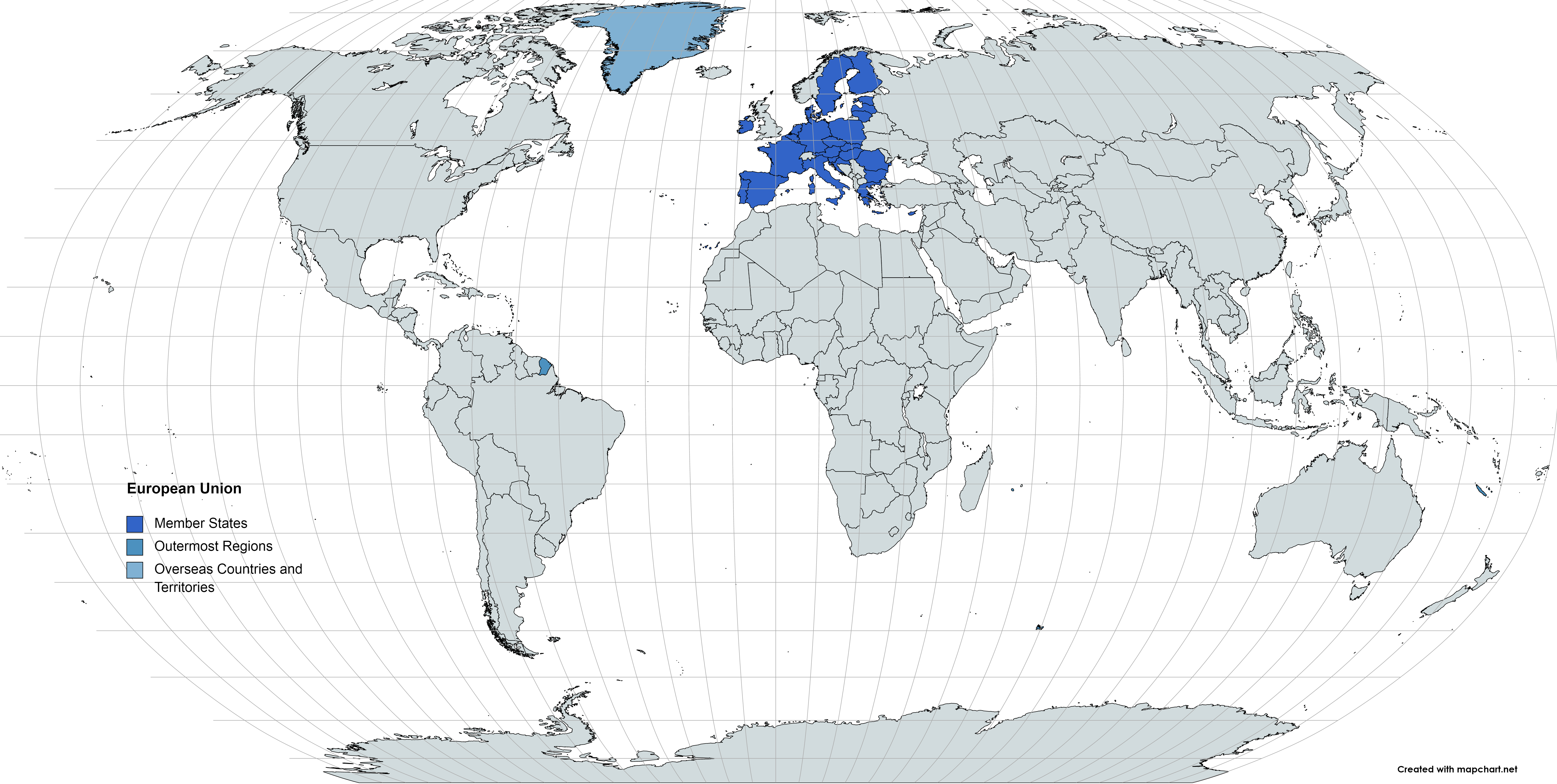
Deutsch: Karte der EU – Überseeische Länder und Hoheitsgebiete (OCT) und die Gebiete in äußerster Randlage (OMR). Diese Karte zeigt den räumlichen Geltungsbereich der Verträge der EU gemäß Artikel 52 des Vertrags über die Europäische Union und Artikel 355 des Vertrags über die Arbeitsweise der Europäischen Union.
Français : Carte de l’Union Européenne, en particulier les Pays et territoires d’outre-mer et les Régions ultrapériphériques. Cette carte montre la portée d’action territoriale des Traités de l’UE comme spécifié par l’Article 52 du Traité sur l’Union Européenne et l’Article 355 du Traité sur le Fonctionnement de l’Union Européenne.
English: Map of the EU – Overseas Countries and Territories (OCT) and Outermost Regions (OMR). This map shows the territorial scope of the Treaties of the EU as specified by Article 52 of the Treaty on European Union and Article 355 of the Treaty on the Functioning of the European Union. |
|
| نېټه | ||
| سرچينه | شخصي اثر | |
| ليکوال | Soumya-8974 | |
| اجازه (دا دوتنه بيا کارول) |
زه، د دې اثر د خپرولو او لمېسلو خاوند، دا دوتنه د لاندې منښتليک پر بنسټ دلته خپروم: This file is licensed under the Creative Commons Attribution-Share Alike 4.0 International license.
|
Captions
Add a one-line explanation of what this file represents
Items portrayed in this file
depicts انګليسي
copyright status انګليسي
copyrighted انګليسي
source of file انګليسي
original creation by uploader انګليسي
۱۶ مې 2021
د دوتنې پېښليک
په يوې نېټې/يوه وخت وټوکۍ چې د هماغه وخت او نېټې دوتنه چې څنگه ښکارېده هماغسې درښکاره شي.
| نېټه/وخت | بټنوک | ډډې | کارن | تبصره | |
|---|---|---|---|---|---|
| اوسنی | ۱۱:۱۲, ۹ جون ۲۰۲۱ | | ۷٬۰۰۰ × ۳٬۵۲۶ (۳٫۲۲ مېگابايټ) | Sbb1413 | Changed the font. |
| ۱۳:۴۲, ۱۶ مې ۲۰۲۱ |  | ۷٬۰۰۰ × ۳٬۵۲۶ (۳٫۲۲ مېگابايټ) | Sbb1413 | {{Information |Description= {{de|1=Karte der EU – Überseeische Länder und Hoheitsgebiete (OCT) und die Gebiete in äußerster Randlage (OMR). Diese Karte zeigt den räumlichen Geltungsbereich der Verträge der EU gemäß Artikel 52 des Vertrags über die Europäische Union und Artikel 355 des [[:de:Vertrag über die Arbeitsweise der Europäischen Union|Vertrags über die Arbeitsweise d... |
د دوتنې کارېدنه
داسې هېڅ کوم مخ نه شته چې د دغې دوتنې سره تړنې ولري.
"https://ps.wikipedia.org/wiki/دوتنه:EU_OCT_and_OMR_map.png" نه اخيستل شوی