فائل:Map_Kashmir_Standoff_2003.png
From Wikipedia, the free encyclopedia
اصل فائل (۸۶۹ × ۶۸۶ پکسلز, فائل حجم: ۵۳ کلوبائٹ, MIME type: image/png)
ایہ فائل Wikimedia Commons توں اے تے دوجیاں ویونتاں تے وی ورتی جاسکدی اے۔ گل بات اس دے فائل گل بات صفحہ تے تھلے دتی گئی۔
خلاصہ
| تفصیلMap Kashmir Standoff 2003.png |
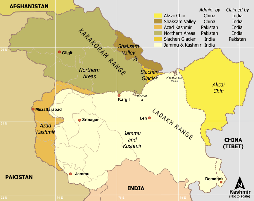
Kashmir region - Political and Military standoff between India, China and Pakistan Self-made from Reference: Atlas of the World (2003 Comprehensive Ed.) - The w:Royal Geographical Society - (ISBN 0540084050) |
| تریخ | ۳ جنوری ۲۰۰۶ (original upload date) |
| سروت | No machine-readable source provided. Own work assumed (based on copyright claims). |
| لکھاری | No machine-readable author provided. Miljoshi assumed (based on copyright claims). |
لائسنس –

|
کاپی کرن، ونڈن تے بدلن دی ایس ڈوکومنٹ لئی اجازت دتی جاندی اے ایہناں GNU Free Documentation License, Version 1.2 شرطاں نال یا مگروں کسے وی چھپے ورین Free Software Foundation توں بنا کسے انویرینٹ سیکشن دے، ناں فرنٹ کور لکھت تے ناں بیک کور لکھت دے۔ لسنس دی اک کاپی سیکشن وچ ہیگی اے جہدا ناں اے GNU Free Documentation License۔http://www.gnu.org/copyleft/fdl.htmlGFDLGNU Free Documentation Licensetruetrue |
| ایس فائل نوں کریٹو کامنز Attribution 2.5 پولینڈ لائسنس دتا گیا. | ||
| ||
| اس لائسنس دا ٹیگ GFDL دے مطابق اس فائل چ پایا گیا اے licensing update۔http://creativecommons.org/licenses/by-sa/3.0/CC BY-SA 3.0Creative Commons Attribution-Share Alike 3.0truetrue |
- تہانوں کھلھ اے:
- حصہ کرنا – کاپی، ونڈنا تے کم بھیجنا
- فیر رلانا – کم نوں فٹ کرنا
- تھلے دتیاں شرطاں نال:
- کس دے ناں – تسیں لازمی ایس کم دے بناں والے بارے دسو جنج اونے آکھیا اے یا جنج لسنس چ آکھیا گیا ہے۔
- اکو جہا شئیر کرو۔ – اگر تسیں بدلدے یا ایس کم تے بناندے تے بنن والے کم نوں اینج دے لسنس نال ای ونڈو گے۔
derivative works
Derivative works of this file: Map Kashmir Standoff 2003 mr.png
Captions
Items portrayed in this file
چترن
copyright status English
copyrighted English
copyright license English
۳ جنوری 2006
فائل دی تریخ
فائل نو اس ویلے دی حالت وچ ویکھن واسطے تاریخ/ویلے تے کلک کرو۔
| تریخ تے ویلہ | نکی مورت | پاسے | ورتن والا | تیپّݨی کرو | |
|---|---|---|---|---|---|
| موجودہ | ۲۲:۵۸, ۲۹ جولائی ۲۰۱۷ | | ۸۶۹ × ۶۸۶ (۵۳ کلوبائٹ) | फ़िलप्रो | Demchok is administered by India |
| ۰۳:۲۸, ۷ جون ۲۰۱۰ |  | ۸۶۹ × ۶۸۶ (۴۴ کلوبائٹ) | Ras67 | cropped | |
| ۲۲:۳۶, ۳ جنوری ۲۰۰۶ |  | ۸۸۵ × ۷۰۳ (۵۸ کلوبائٹ) | Miljoshi | Kashmir region - Political and Military standoff between India, China and Pakistan Reference: Atlas of the World (2003 Comprehensive Ed.) - The w:Royal Geographic Society - w:ISBN 0540084050 - Self-made. |
فائل دی ورتوں
تھلے دتے گئے 1 صفحے اس فائل نال جُڑدے نیں
فائل ویاپک ورتوں
ایہہ دوجے وکیاں ایس فائل نوں ورتدے نیں –
- an.wikipedia.org تے ورتوں
- de.wikipedia.org تے ورتوں
- en.wikipedia.org تے ورتوں
- fr.wikipedia.org تے ورتوں
- hi.wikipedia.org تے ورتوں
- ja.wikipedia.org تے ورتوں
- no.wikipedia.org تے ورتوں
- pl.wikipedia.org تے ورتوں
- ta.wiktionary.org تے ورتوں
میٹا ڈیٹا
اس فائل وچ ہور وی معلومات نے، شاید او ڈیجیٹل کیمرے یا سکینر نے پائیاں گئیاں نے جس نال اینو کچھیا یا ڈیجیٹل بنایا گیا اے۔
اگر فائل نو ایدی اصلی حالت توں تبدیل کیتا گیا اے تے کجھ تفصیلات تبدیل ہوئی فائل دے بارے چ نئیں دسن گیاں۔
| ہوریزنٹل ریزولوشن | ۲۸.۳۵ dpc |
|---|---|
| ورٹیکل ریزولوشن | ۲۸.۳۵ dpc |