فائل:Allegheny_Monongahela_Ohio.jpg
From Wikipedia, the free encyclopedia
اصل فائل (۱,۴۴۶ × ۹۱۸ پکسلز, فائل حجم: ۱.۳۸ میگابائٹ, MIME type: image/jpeg)
ایہ فائل Wikimedia Commons توں اے تے دوجیاں ویونتاں تے وی ورتی جاسکدی اے۔ گل بات اس دے فائل گل بات صفحہ تے تھلے دتی گئی۔
|
This is an image of a place or building that is listed on the National Register of Historic Places in the United States of America. Its reference number is 79003143. |
| تفصیلAllegheny Monongahela Ohio.jpg |
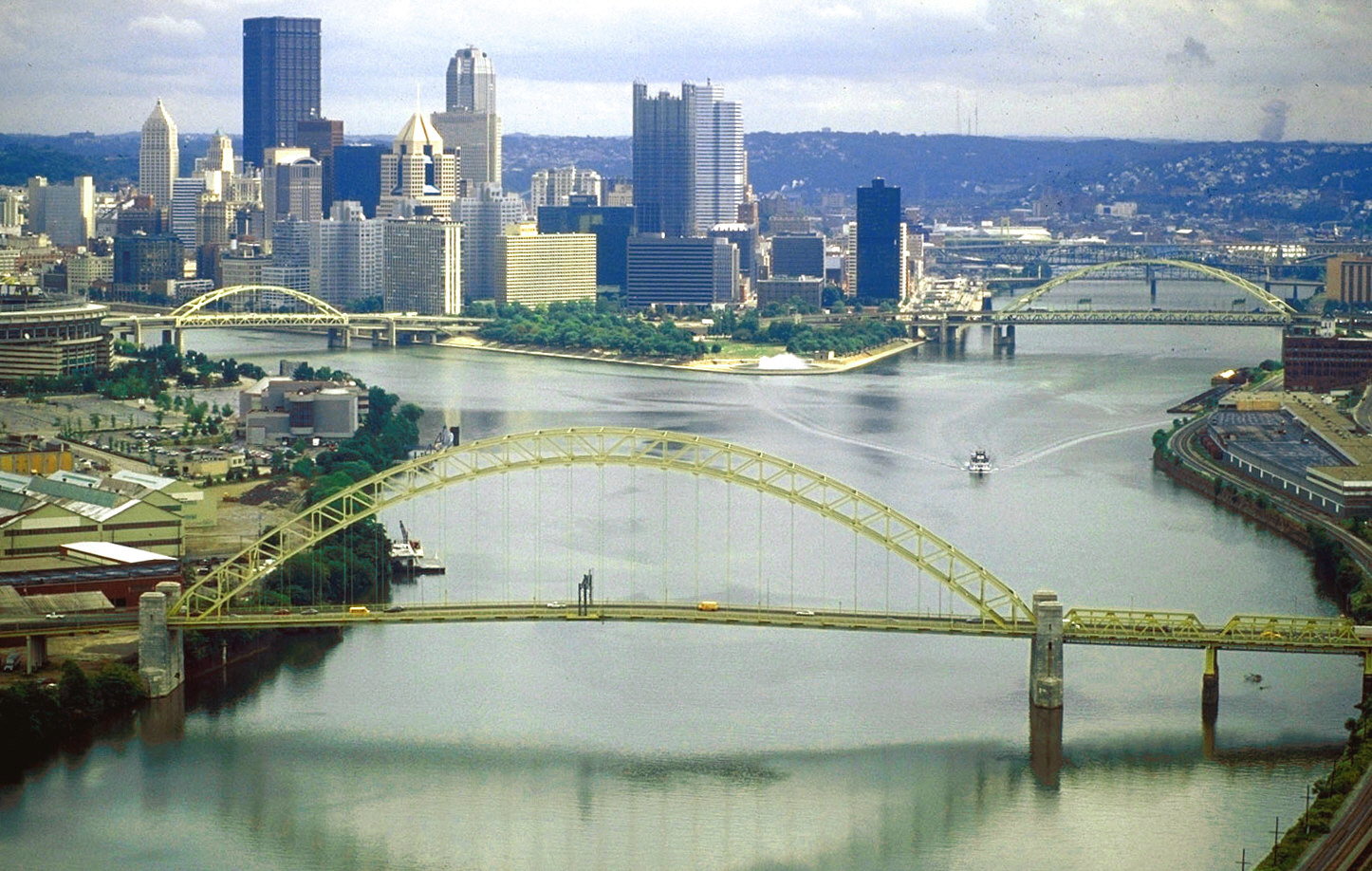
English: The source of the Ohio River at “The Point” in Point State Park, Pittsburgh, Pennsylvania.
|
||||
| تریخ | |||||
| سروت |
U.S. Army Corps of Engineers Digital Visual Library Image page Image description page Digital Visual Library home page |
||||
| لکھاری | David Schwab, U.S. Army Corps of Engineers | ||||
| اجازت (فائل نوں دوبارہ ورتنا) |
|
||||
| Location InfoField | Pittsburgh, Pennsylvania, USA |
| Camera location | ۴۰° ۲۶′ ۴۷.۶۹″ N, ۸۰° ۰۱′ ۳۶.۹۷″ W | View this and other nearby images on: OpenStreetMap |
|---|
| This is a retouched picture, which means that it has been digitally altered from its original version. Modifications: colors adjusted. Modifications made by Glabb.
|
Captions
Items portrayed in this file
چترن
Fort Pitt Bridge English
Fort Duquesne Bridge English
۷ اپریل 1998
coordinates of the point of view English
40°26'47.692"N, 80°1'36.970"W
location of creation English
media type English
image/jpeg
checksum English
3dffcccccc527fc3f9a25b6c790824b57327a530
data size English
۱,۴۴۷,۹۰۲ بائٹ
height English
۹۱۸ pixel
width English
۱,۴۴۶ pixel
فائل دی تریخ
فائل نو اس ویلے دی حالت وچ ویکھن واسطے تاریخ/ویلے تے کلک کرو۔
| تریخ تے ویلہ | نکی مورت | پاسے | ورتن والا | تیپّݨی کرو | |
|---|---|---|---|---|---|
| موجودہ | ۱۷:۰۶, ۲۵ جون ۲۰۱۰ | | ۱,۴۴۶ × ۹۱۸ (۱.۳۸ میگابائٹ) | Glabb | colors adjusted |
| ۰۵:۳۱, ۲۴ مارچ ۲۰۰۷ |  | ۱,۴۴۶ × ۹۱۸ (۴۱۷ کلوبائٹ) | DanMS | {{Information | Description = {{en|The source of the Ohio River at “The Point” in Pittsburgh, Pennsylvania, USA. The Allegheny River (left) and the Monongahela River (right) join to form the Ohio here. The West End Bridge crosses the Ohio in the fo |
فائل دی ورتوں
تھلے دتے گئے 1 صفحے اس فائل نال جُڑدے نیں
فائل ویاپک ورتوں
ایہہ دوجے وکیاں ایس فائل نوں ورتدے نیں –
- ar.wikipedia.org تے ورتوں
- ba.wikipedia.org تے ورتوں
- bg.wikipedia.org تے ورتوں
- bs.wikipedia.org تے ورتوں
- da.wikipedia.org تے ورتوں
- de.wikipedia.org تے ورتوں
- el.wikipedia.org تے ورتوں
- en.wikipedia.org تے ورتوں
- City
- Ohio River
- Allegheny River
- List of crossings of the Ohio River
- West End (Pittsburgh)
- Confluence
- West End Bridge
- List of bridges of Pittsburgh
- National Register of Historic Places listings in Pittsburgh, Pennsylvania
- List of Pennsylvania state historical markers in Allegheny County
- User:OrdinaryGiraffe/Books/Vital/L2/A
- fa.wikipedia.org تے ورتوں
- fo.wikipedia.org تے ورتوں
- fr.wikipedia.org تے ورتوں
- fy.wikipedia.org تے ورتوں
- hy.wikipedia.org تے ورتوں
- incubator.wikimedia.org تے ورتوں
- it.wikipedia.org تے ورتوں
- ja.wikipedia.org تے ورتوں
- ka.wikipedia.org تے ورتوں
- kn.wikipedia.org تے ورتوں
- lt.wikipedia.org تے ورتوں
- mr.wikipedia.org تے ورتوں
- nl.wikipedia.org تے ورتوں
- nn.wikipedia.org تے ورتوں
- no.wikipedia.org تے ورتوں
- pih.wikipedia.org تے ورتوں
- pt.wikipedia.org تے ورتوں
- ru.wikipedia.org تے ورتوں
- ru.wiktionary.org تے ورتوں
- sr.wikipedia.org تے ورتوں
- sv.wikipedia.org تے ورتوں
ایس فائل دا ویکھو ہور جگت ورتن .
میٹا ڈیٹا
اس فائل وچ ہور وی معلومات نے، شاید او ڈیجیٹل کیمرے یا سکینر نے پائیاں گئیاں نے جس نال اینو کچھیا یا ڈیجیٹل بنایا گیا اے۔
اگر فائل نو ایدی اصلی حالت توں تبدیل کیتا گیا اے تے کجھ تفصیلات تبدیل ہوئی فائل دے بارے چ نئیں دسن گیاں۔
| جے پی ای جی شائل کومنٹ | LEAD Technologies Inc. V1.01 |
|---|