File:OttomanEmpireIn1683-zh-classical.png
From Wikipedia, the free encyclopedia
ایس وکھالے دا ناپ: ۶۳۷ × ۵۹۹ پکسلز۔ دوجے ریزولوشنز: ۲۵۵ × ۲۴۰ پکسلز | ۵۱۰ × ۴۸۰ پکسلز | ۸۱۶ × ۷۶۸ پکسلز | ۱,۰۸۸ × ۱,۰۲۴ پکسلز | ۱,۹۶۶ × ۱,۸۵۰ پکسلز ۔
اصل فائل (۱,۹۶۶ × ۱,۸۵۰ پکسلز, فائل حجم: ۴۴۲ کلوبائٹ, MIME type: image/png)
ایہ فائل Wikimedia Commons توں اے تے دوجیاں ویونتاں تے وی ورتی جاسکدی اے۔ گل بات اس دے فائل گل بات صفحہ تے تھلے دتی گئی۔
خلاصہ
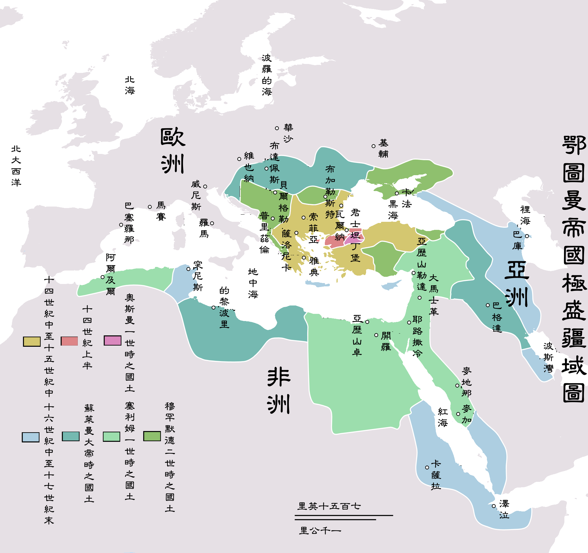
| تفصیلOttomanEmpireIn1683-zh-classical.png | Map depicting the Ottoman Empire at its greatest extent, in 1683. |
| تریخ | |
| سروت | Self drawn, mainly based on Robert Mantran (ed.), Histoire de l'Empire Ottoman, Paris: Fayard (1989), also en:List of Ottoman Empire dominated territories, Image:Ottoman 1683.png, [1], and [2]. Background map modified from Image:A large blank world map with oceans marked in blue.svg. |
| لکھاری | Atilim Gunes Baydin |
| اجازت (فائل نوں دوبارہ ورتنا) |
Permission is given for anyone to use this for any possible purpose. |
| دوجے ورژن |
[سودھو]
|


Originally picture was uploaded to here.
The Classical Chinese Modification is made by User:Itsmine.
لائسنس –
| Public domainPublic domainfalsefalse |
| |
اس کم نوں لوکاں لئی ایدے لکھاریAtilimGunesBaydin, at the English وکیپیڈیا project نے دے دتا اے، اے سارے جگ واسطے لاگو اے۔ In case this is not legally possible: |
Captions
Add a one-line explanation of what this file represents
Items portrayed in this file
چترن
۲۱ دسمبر 2006
فائل دی تریخ
فائل نو اس ویلے دی حالت وچ ویکھن واسطے تاریخ/ویلے تے کلک کرو۔
| تریخ تے ویلہ | نکی مورت | پاسے | ورتن والا | تیپّݨی کرو | |
|---|---|---|---|---|---|
| موجودہ | ۱۱:۴۴, ۱۱ مئی ۲۰۰۷ | | ۱,۹۶۶ × ۱,۸۵۰ (۴۴۲ کلوبائٹ) | Itsmine | |
| ۱۰:۳۱, ۱۰ مئی ۲۰۰۷ |  | ۱,۹۶۶ × ۱,۸۵۰ (۴۳۸ کلوبائٹ) | Itsmine | ||
| ۱۰:۲۸, ۱۰ مئی ۲۰۰۷ |  | ۱,۹۶۶ × ۱,۸۵۰ (۴۳۸ کلوبائٹ) | Itsmine | ||
| ۱۹:۱۰, ۹ مئی ۲۰۰۷ |  | ۱,۹۶۶ × ۱,۸۵۰ (۴۳۹ کلوبائٹ) | Itsmine | ||
| ۱۹:۰۱, ۹ مئی ۲۰۰۷ |  | ۱,۹۶۶ × ۱,۸۵۰ (۴۳۹ کلوبائٹ) | Itsmine | {{Information |Description=Map depicting the Ottoman Empire at its greatest extent, in 1683. |Source=Self drawn, mainly based on ''Robert Mantran (ed.), Histoire de l'Empire Ottoman, Paris: Fayard (1989)'', also [[:en:List of Ottoma |
فائل دی ورتوں
اس فائل نال جڑیا کوئی صفحہ نئیں۔
فائل ویاپک ورتوں
ایہہ دوجے وکیاں ایس فائل نوں ورتدے نیں –
- vi.wikipedia.org تے ورتوں
- zh-classical.wikipedia.org تے ورتوں
- zh-yue.wikipedia.org تے ورتوں
- zh.wikipedia.org تے ورتوں