File:FLN_soccer_team_visited_countries.png
From Wikipedia, the free encyclopedia
اس توں وڈی مورت موجود نہیں۔
FLN_soccer_team_visited_countries.png (۶۹۵ × ۳۵۴ پکسلز, فائل حجم: ۴۱ کلوبائٹ, MIME type: image/png)
ایہ فائل Wikimedia Commons توں اے تے دوجیاں ویونتاں تے وی ورتی جاسکدی اے۔ گل بات اس دے فائل گل بات صفحہ تے تھلے دتی گئی۔
| تفصیلFLN soccer team visited countries.png |
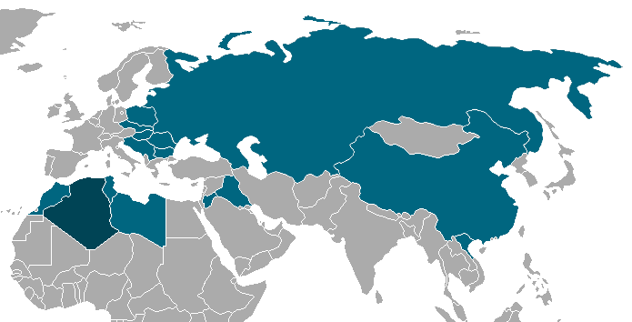
Français : Carte montrant les pays dans lesqulles l'équipe du FLN de football est passé durant sa tournée entre 1958 et 1962. |
| تریخ | (UTC) |
| سروت | |
| لکھاری |
|
| This is a retouched picture, which means that it has been digitally altered from its original version. The original can be viewed here: BlankMap-World-1962.png:
|
میں، اس کم دے کاپیرائٹ دا مالک، اس کم نوں اس لائسنس دے مطابق چھاپدا واں:
| ایس فائل نوں کریٹو کامنز Attribution 2.5 پولینڈ لائسنس دتا گیا. | ||
| ||
| اس لائسنس دا ٹیگ GFDL دے مطابق اس فائل چ پایا گیا اے licensing update۔http://creativecommons.org/licenses/by-sa/3.0/CC BY-SA 3.0Creative Commons Attribution-Share Alike 3.0truetrue |

|
کاپی کرن، ونڈن تے بدلن دی ایس ڈوکومنٹ لئی اجازت دتی جاندی اے ایہناں GNU Free Documentation License, Version 1.2 شرطاں نال یا مگروں کسے وی چھپے ورین Free Software Foundation توں بنا کسے انویرینٹ سیکشن دے، ناں فرنٹ کور لکھت تے ناں بیک کور لکھت دے۔ لسنس دی اک کاپی سیکشن وچ ہیگی اے جہدا ناں اے GNU Free Documentation License۔http://www.gnu.org/copyleft/fdl.htmlGFDLGNU Free Documentation Licensetruetrue |
تسیں اپنی مرضی دا لائسنس چݨ سکدے اوہ۔
پہلا اپلوڈ دا ریکارڈ
This image is a derivative work of the following images:
- File:BlankMap-World-1962.png licensed with Cc-by-sa-3.0-migrated, GFDL
- 2007-09-24T02:49:22Z Hoshie 1357x628 (49120 Bytes) put the (N/S) Yemen boundary in white due to the fact the boundaries in southern Saudi Arabia have been disputed, undemarcated, or undisclosed over the years.
- 2007-08-06T00:43:46Z Hoshie 1357x628 (49165 Bytes) Added Cabinda; under same lic. as original.
- 2007-01-28T10:27:46Z Hoshie 1357x628 (49159 Bytes) added Ifni, a Spanish enclave.
- 2007-01-05T23:54:02Z Roke 1357x628 (49104 Bytes) Blank world map with 1962 borders. This is accurate between December 19, 1961 (India takes over the Portugese colony of Goa) and July 1, 1962 (Belgian colony of Ruanda-Urundi separated into Rwanda and Burundi.) See [[w:List o
Uploaded with derivativeFX
Captions
Add a one-line explanation of what this file represents
Items portrayed in this file
چترن
copyright status English
copyrighted English
۸ اپریل 2010
فائل دی تریخ
فائل نو اس ویلے دی حالت وچ ویکھن واسطے تاریخ/ویلے تے کلک کرو۔
| تریخ تے ویلہ | نکی مورت | پاسے | ورتن والا | تیپّݨی کرو | |
|---|---|---|---|---|---|
| موجودہ | ۰۱:۲۴, ۹ اپریل ۲۰۱۰ | | ۶۹۵ × ۳۵۴ (۴۱ کلوبائٹ) | Clapsus | recadrage |
| ۰۰:۵۴, ۹ اپریل ۲۰۱۰ |  | ۱,۳۵۷ × ۶۲۸ (۵۲ کلوبائٹ) | Clapsus | +Irak+Joradanie | |
| ۰۰:۴۹, ۹ اپریل ۲۰۱۰ |  | ۱,۳۵۷ × ۶۲۸ (۵۱ کلوبائٹ) | Clapsus | {{Information |Description={{fr|Carte montrant les pays dans lesqulles l'équipe du FLN de football est passé durant sa tournée entre 1958 et 1962.}} |Source=*File:BlankMap-World-1962.png |Date=2010-04-08 19:44 ( |
فائل دی ورتوں
اس فائل نال جڑیا کوئی صفحہ نئیں۔
فائل ویاپک ورتوں
ایہہ دوجے وکیاں ایس فائل نوں ورتدے نیں –
- ar.wikipedia.org تے ورتوں
- de.wikipedia.org تے ورتوں
- fr.wikipedia.org تے ورتوں