Plac Niepodległości w Toruniu
Z Wikipedii, wolnej encyklopedii
Z Wikipedii, wolnej encyklopedii
Plac Niepodległości w Toruniu (również znane jako Rondo Niepodległości[1]) – skrzyżowanie znajdujące się w centrum Torunia, położone pomiędzy wylotami ulic: Kraszewskiego, Czerwonej Drogi, al. Jana Pawła II i al. 700-lecia Torunia. Jest to skrzyżowanie typu wyspa centralna z rozszerzonymi wlotami. Przez rondo przechodzą drogi krajowe nr 15, 80 i 91. Przez rondo przechodzą tory tramwajowe w kierunku wschód-zachód, trasowe symetrycznie względem głównej osi skrzyżowania[1].
| Stare Miasto | |
 Plac po przebudowie, wiosna 2021 roku | |
| Państwo | |
|---|---|
| Miejscowość | |
Położenie na mapie Torunia 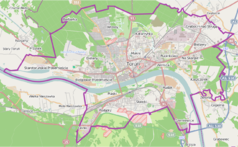 | |
Położenie na mapie Polski  | |
Położenie na mapie województwa kujawsko-pomorskiego 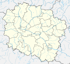 | |
Obiekty znajdujące się w bezpośrednim sąsiedztwie Ronda Niepodległości[1]:
W latach 2019–2021 plac Niepodległości został przebudowany. Skrzyżowanie zastąpiono rondem z sygnalizacją świetlną. Podczas remontu położono nową nawierzchnię asfaltową. Przebudowa była częścią projektu „Przebudowa układu torowo-drogowego w ulicy Wały gen. Sikorskiego i alei św. Jana Pawła II wraz z budową pasa tramwajowo-autobusowego w Toruniu - BiT City II”. Koszt remontu wyniósł 72 mln złotych, nieco ponad 36 mln złotych pochodziło z Europejskiego Funduszu Rozwoju Regionalnego[2].
Seamless Wikipedia browsing. On steroids.
Every time you click a link to Wikipedia, Wiktionary or Wikiquote in your browser's search results, it will show the modern Wikiwand interface.
Wikiwand extension is a five stars, simple, with minimum permission required to keep your browsing private, safe and transparent.
