Sant’Erasmo
Z Wikipedii, wolnej encyklopedii
Z Wikipedii, wolnej encyklopedii
Sant’Erasmo – wyspa położona na wschód od historycznego centrum Wenecji w Północnych Włoszech. Jest drugą co do wielkości po Wenecji. Znajduje się w samym centrum trójkąta, jaki tworzą wyspy: Murano, Burano oraz przylądek Punta Sabbioni.
 Kościół Cristo Re, Sant’Erasmo, 2010 | |
| Kontynent | |
|---|---|
| Państwo | |
| Akwen | |
| Powierzchnia |
3,26 km² |
| Populacja (2011) • liczba ludności • gęstość |
|
Położenie na mapie Wenecji  | |
Położenie na mapie Włoch  | |
Położenie na mapie Wenecji Euganejskiej 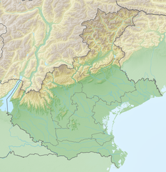 | |
Wyspa administracyjnie należy do Municipalità di Venezia-Murano-Burano[1], należąc jednocześnie do tzw. Parco della Laguna[2].
Wyspa stanowi tradycyjny ogród dla metropolii. Uprawiane są przede wszystkim karczochy, szparagi oraz osty. Najbardziej zamieszkaną część wyspy stanowią okolice jedynego na wyspie kościoła dedykowanego Chrystusowi Królowi. To część od strony Laguny Weneckiej. Na wyspie otwarty jest niewielki supermarket, bar-pizzeria, restauracja, hotel, szkoła podstawowa i przedszkole[3].
_Via_delle_Motte_45.458036,_12.407726.jpg)
_Via_delle_Motte_45.455718,_12.402925.jpg)
_-_Torre_Massimiliana.jpg)
Na wyspie znajduje się przystanki vaporetto, weneckiego tramwaju wodnego (linia 13, Sant’Erasmo Capannone, Sant’Erasmo Chiesa, Sant’Erasmo Punta Vela)[6].
Seamless Wikipedia browsing. On steroids.
Every time you click a link to Wikipedia, Wiktionary or Wikiquote in your browser's search results, it will show the modern Wikiwand interface.
Wikiwand extension is a five stars, simple, with minimum permission required to keep your browsing private, safe and transparent.
