File:Bay-of-Piran_maritime-boundary-dispute.jpg
Z Wikipedii, wolnej encyclopedia
Bay-of-Piran_maritime-boundary-dispute.jpg (709 × 600 pikseli, rozmiar pliku: 160 KB, typ MIME: image/jpeg)
| Plik Bay-of-Piran maritime-boundary-dispute.jpg znajduje się w Wikimedia Commons – repozytorium wolnych zasobów. Dane z jego strony opisu znajdują się poniżej. |
Opis


| OpisBay-of-Piran maritime-boundary-dispute.jpg |
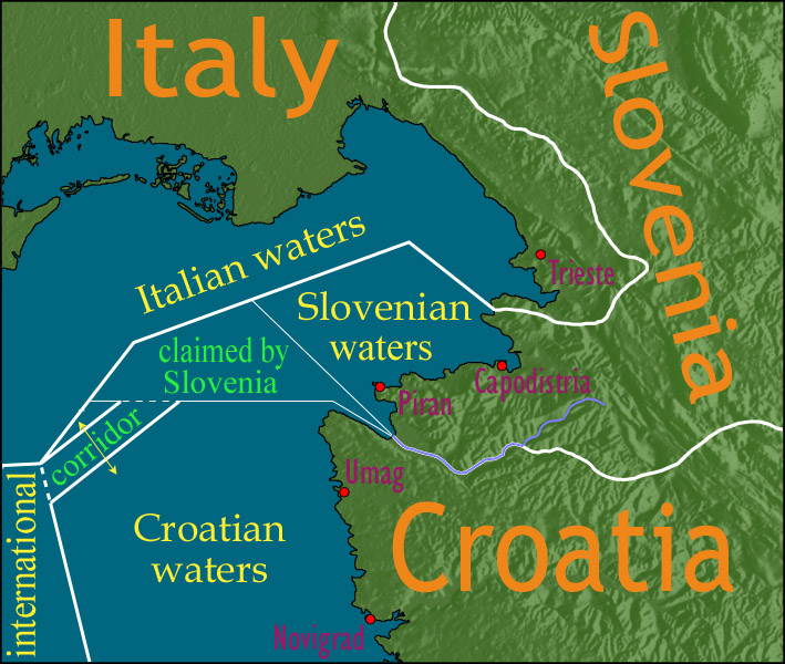
English: Map showing a diplomatic dispute resulting from Slovenia's desire to obtain a direct corridor from its own territorial waters to international waters, to avoid the necessity of Slovenian ships having to sail through the territorial waters of any other country to get to the high seas. Slovenia's only seacoast is in the Bay of Piran / Gulf of Trieste (as shown in this map), and its only commercial seaport is Capodistria / Koper (the eastern of the two red dots in Slovenia on this map), while Italy and Croatia both have long seacoasts outside the area shown in this map.
Slovenia's claim to the area labelled with green text, and the existence of a corridor to international waters, would have been allowed by Croatia under the Drnovšek-Račan agreement, but this was never ratified by either countries' parliaments. This is an English version of image de:Bild:Grenzstreit-Bucht-von-Piran.jpg, created using image Image:BorderDispute_BayOfPiran_blank.png. Raw Adobe Photoshop PSD files (with all text on different type layers) are available on request. |
| Data | |
| Źródło | File:BorderDispute_BayOfPiran_blank.png |
| Autor |
|
| Licencja (Ponowne użycie tego pliku) |
The underlying source Image:BorderDispute_BayOfPiran_blank.png is declared to be GFDL, while I declare my changes to it to be PD. |
| Inne wersje | Prace pochodne od tego pliku: Bay-of-Piran maritime-boundary-dispute.svg |
Poprawność tej mapy lub nazwy tego pliku jest podawana w wątpliwość.
Powód: abstract lexical semantics and use of exonyms. See talk:Bay-of-Piran maritime-boundary-dispute.jpg |  |
Licencja

|
Udziela się zgody na kopiowanie, rozpowszechnianie oraz modyfikowanie tego dokumentu zgodnie z warunkami GNU Licencji Wolnej Dokumentacji, w wersji 1.2 lub nowszej opublikowanej przez Free Software Foundation; bez niezmiennych sekcji, bez treści umieszczonych na frontowej lub tylnej stronie okładki. Kopia licencji załączona jest w sekcji zatytułowanej GNU Licencja Wolnej Dokumentacji.http://www.gnu.org/copyleft/fdl.htmlGFDLGNU Free Documentation Licensetruetrue |
| Ten plik udostępniony jest na licencji Creative Commons Uznanie autorstwa – Na tych samych warunkach 3.0. | ||
| ||
| Ten szablon został dodany jako element zmiany licencjonowania.http://creativecommons.org/licenses/by-sa/3.0/CC BY-SA 3.0Creative Commons Attribution-Share Alike 3.0truetrue |
Podpisy
Obiekty przedstawione na tym zdjęciu
przedstawia
14 gru 2006
image/jpeg
b36371284418dd9ef27914bee5a865d33c768a3d
164 071 bajt
600 piksel
709 piksel
Historia pliku
Kliknij na datę/czas, aby zobaczyć, jak plik wyglądał w tym czasie.
| Data i czas | Miniatura | Wymiary | Użytkownik | Opis | |
|---|---|---|---|---|---|
| aktualny | 16:17, 8 sty 2007 | | 709 × 600 (160 KB) | AnonMoos | adding city names |
| 20:13, 24 gru 2006 |  | 709 × 600 (156 KB) | AnonMoos | deepening colors slightly | |
| 16:00, 14 gru 2006 |  | 709 × 600 (156 KB) | AnonMoos | Map showing diplomatic dispute over Slovenia's desire to obtain a direct corridor from its own territorial waters to international waters, to avoid Slovenian ships having to sail through the territorial waters of any other country to get to the high seas. |
Lokalne wykorzystanie pliku
Poniższa strona korzysta z tego pliku:
Globalne wykorzystanie pliku
Ten plik jest wykorzystywany także w innych projektach wiki:
- Wykorzystanie na de.wikipedia.org
- Wykorzystanie na en.wikipedia.org
- Wykorzystanie na en.wikinews.org
- Wykorzystanie na es.wikipedia.org
- Wykorzystanie na fy.wikipedia.org
- Wykorzystanie na it.wikipedia.org
- Wykorzystanie na ja.wikipedia.org
- Wykorzystanie na ko.wikipedia.org
- Wykorzystanie na sl.wikipedia.org
- Wykorzystanie na zh.wikipedia.org
Metadane
Niniejszy plik zawiera dodatkowe informacje, prawdopodobnie dodane przez aparat cyfrowy lub skaner użyte do wygenerowania tego pliku.
Jeśli plik był modyfikowany, dane mogą być częściowo niezgodne z parametrami zmodyfikowanego pliku.
| _error | 0 |
|---|