File:1952_Electoral_Map.png
From Wikipedia, the free encyclopedia
ਇਸ ਝਾਤ ਦਾ ਅਕਾਰ: 800 × 430 ਪਿਕਸਲ. ਹੋਰ ਰੈਜ਼ੋਲਿਊਸ਼ਨਜ਼: 320 × 172 ਪਿਕਸਲ | 640 × 344 ਪਿਕਸਲ | 1,182 × 635 ਪਿਕਸਲ.
ਅਸਲ ਫ਼ਾਈਲ (1,182 × 635 ਪਿਕਸਲ, ਫ਼ਾਈਲ ਅਕਾਰ: 158 KB, MIME ਕਿਸਮ: image/png)
ਇਹ ਫ਼ਾਈਲ Wikimedia Commons ਦੀ ਹੈ ਅਤੇ ਹੋਰ ਪਰਿਯੋਜਨਾਵਾਂ ਵਿੱਚ ਵੀ ਵਰਤੀ ਜਾ ਸਕਦੀ ਹੈ । ਇਸ ਫ਼ਾਈਲ ਦੇ ਵੇਰਵਾ ਸਫ਼ੇ ਵਿੱਚ ਮੌਜੂਦ ਵੇਰਵਾ ਹੇਠ ਦਿਸ ਰਿਹਾ ਹੈ।
| U.S. presidential election maps from the National Atlas of the United States |
| See also: SVG maps |
| 1789 · 1792 · 1796 · 1800 · 1804 · 1808 · 1812 · 1816 · 1820 · 1824 · 1828 · 1832 · 1836 · 1840 · 1844 · 1848 · 1852 · 1856 · 1860 · 1864 · 1868 · 1872 · 1876 · 1880 · 1884 · 1888 · 1892 · 1896 · 1900 · 1904 · 1908 · 1912 · 1916 · 1920 · 1924 · 1928 · 1932 · 1936 · 1940 · 1944 · 1948 · 1952 · 1956 · 1960 · 1964 · 1968 · 1972 · 1976 · 1980 · 1984 · 1988 · 1992 · 1996 · 2000 · 2004 |
ਸਾਰ
| ਵੇਰਵਾ1952 Electoral Map.png |
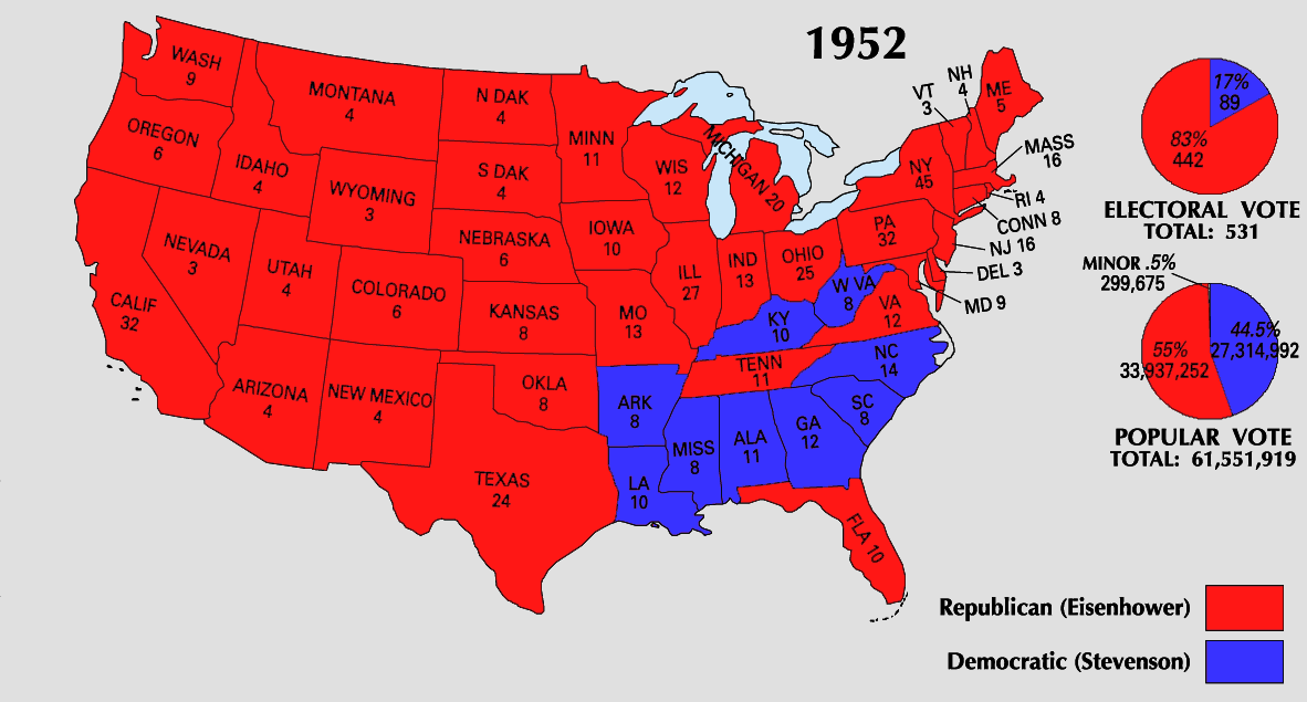
English: 1952 Electoral College Map |
| ਸਰੋਤ | https://nationalmap.gov/small_scale/printable/elections.html |
| ਲਿਖਾਰੀ | United States Geological Survey |
ਲਸੰਸ
| Public domainPublic domainfalsefalse |
This map was obtained from an edition of the National Atlas of the United States. Like almost all works of the U.S. federal government, works from the National Atlas are in the public domain in the United States.
Online access: NationalAtlas.gov | 1970 print edition: Library of Congress, Perry-Castañeda Library čeština | Deutsch | English | français | Bahasa Indonesia | italiano | македонски | മലയാളം | sicilianu | 中文 | 中文(简体) | 中文(繁體) | +/− |
ਸੁਰਖੀ
Add a one-line explanation of what this file represents
Items portrayed in this file
ਚਿਤਰਨ
image/png
checksum ਅੰਗਰੇਜ਼ੀ
b5fb0f927db4fd69bd3a8c2016c9d90b73434bc1
1,61,543 ਬਾਈਟ
height ਅੰਗਰੇਜ਼ੀ
635 ਪਿਕਸਲ
width ਅੰਗਰੇਜ਼ੀ
1,182 ਪਿਕਸਲ
ਫ਼ਾਈਲ ਦਾ ਅਤੀਤ
ਤਾਰੀਖ/ਸਮੇਂ ’ਤੇ ਕਲਿੱਕ ਕਰੋ ਤਾਂ ਉਸ ਸਮੇਂ ਦੀ ਫਾਈਲ ਪੇਸ਼ ਹੋ ਜਾਵੇਗੀ।
| ਮਿਤੀ/ਸਮਾਂ | ਨਮੂਨਾ | ਨਾਪ | ਵਰਤੋਂਕਾਰ | ਟਿੱਪਣੀ | |
|---|---|---|---|---|---|
| ਮੌਜੂਦਾ | 22:19, 25 ਜੂਨ 2008 | | 1,182 × 635 (158 KB) | Tallicfan20 | |
| 21:50, 25 ਜੂਨ 2008 |  | 1,182 × 635 (158 KB) | Tallicfan20 | better coloring | |
| 02:39, 25 ਮਈ 2008 |  | 1,182 × 635 (150 KB) | Tallicfan20 | ||
| 18:15, 16 ਮਈ 2008 |  | 1,182 × 635 (97 KB) | Tallicfan20 | {{Information |Description=1952 Electoral College Map |Source=National Atlas |Date=5/16/2008 |Author=National Atlas |Permission=PD |other_versions= }} {{PD-USGov-Atlas}} |
ਫ਼ਾਈਲ ਦੀ ਵਰਤੋਂ
ਇਸ ਫ਼ਾਈਲ ਦੀ ਵਰਤੋਂ ਕਰਨ ਵਾਲੇ ਕੋਈ ਪੰਨੇ ਨਹੀਂ ਹਨ।
ਫ਼ਾਈਲ ਦੀ ਵਿਆਪਕ ਵਰਤੋਂ
ਇਸ ਫ਼ਾਈਲ ਨੂੰ ਹੋਰ ਹੇਠ ਲਿਖੇ ਵਿਕੀ ਵਰਤਦੇ ਹਨ:
- en.wikipedia.org ਉੱਤੇ ਵਰਤੋਂ
- fi.wikipedia.org ਉੱਤੇ ਵਰਤੋਂ
- sv.wikipedia.org ਉੱਤੇ ਵਰਤੋਂ
- uk.wikipedia.org ਉੱਤੇ ਵਰਤੋਂ
ਮੈਟਾਡੈਟਾ
ਇਸ ਫ਼ਾਈਲ ਵਿੱਚ ਵਾਧੂ ਜਾਣਕਾਰੀਆਂ ਹਨ, ਜੋ ਸ਼ਾਇਦ ਉਸ ਕੈਮਰੇ ਜਾਂ ਸਕੈਨਰ ਦੀ ਦੇਣ ਹਨ ਜੋ ਇਸਨੂੰ ਬਣਾਉਣ ਲਈ ਵਰਤਿਆ ਗਿਆ। ਜੇ ਇਸ ਫ਼ਾਈਲ ਵਿੱਚ ਕੋਈ ਤਬਦੀਲੀ ਕੀਤੀ ਗਈ ਹੈ ਤਾਂ ਹੋ ਸਕਦਾ ਹੈ ਕੁਝ ਵੇਰਵੇ ਬਦਲੀ ਫ਼ਾਈਲ ਦਾ ਸਹੀ ਰੂਪਮਾਨ ਨਾ ਹੋਣ।
| ਲੇਟਵੀਂ ਨੁਕਤਾ-ਗਿਣਤੀ | 28.35 dpc |
|---|---|
| ਖੜ੍ਹਵੀਂ ਨੁਕਤਾ-ਗਿਣਤੀ | 28.35 dpc |