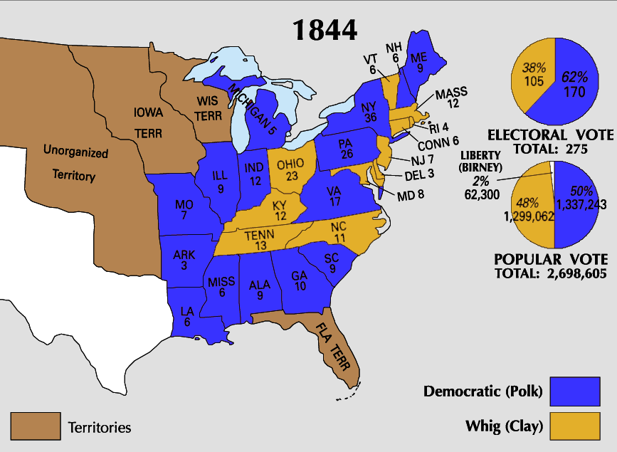
File:1844_Electoral_Map.png
From Wikipedia, the free encyclopedia
ਇਸ ਝਾਤ ਦਾ ਅਕਾਰ: 800 × 586 ਪਿਕਸਲ. ਹੋਰ ਰੈਜ਼ੋਲਿਊਸ਼ਨਜ਼: 320 × 234 ਪਿਕਸਲ | 640 × 469 ਪਿਕਸਲ | 867 × 635 ਪਿਕਸਲ.
ਅਸਲ ਫ਼ਾਈਲ (867 × 635 ਪਿਕਸਲ, ਫ਼ਾਈਲ ਅਕਾਰ: 124 KB, MIME ਕਿਸਮ: image/png)
ਇਹ ਫ਼ਾਈਲ Wikimedia Commons ਦੀ ਹੈ ਅਤੇ ਹੋਰ ਪਰਿਯੋਜਨਾਵਾਂ ਵਿੱਚ ਵੀ ਵਰਤੀ ਜਾ ਸਕਦੀ ਹੈ । ਇਸ ਫ਼ਾਈਲ ਦੇ ਵੇਰਵਾ ਸਫ਼ੇ ਵਿੱਚ ਮੌਜੂਦ ਵੇਰਵਾ ਹੇਠ ਦਿਸ ਰਿਹਾ ਹੈ।
| U.S. presidential election maps from the National Atlas of the United States |
| See also: SVG maps |
| 1789 · 1792 · 1796 · 1800 · 1804 · 1808 · 1812 · 1816 · 1820 · 1824 · 1828 · 1832 · 1836 · 1840 · 1844 · 1848 · 1852 · 1856 · 1860 · 1864 · 1868 · 1872 · 1876 · 1880 · 1884 · 1888 · 1892 · 1896 · 1900 · 1904 · 1908 · 1912 · 1916 · 1920 · 1924 · 1928 · 1932 · 1936 · 1940 · 1944 · 1948 · 1952 · 1956 · 1960 · 1964 · 1968 · 1972 · 1976 · 1980 · 1984 · 1988 · 1992 · 1996 · 2000 · 2004 |
ਸਾਰ
| ਵੇਰਵਾ1844 Electoral Map.png |
This file has no description, and may be lacking other information.
Please provide a meaningful description of this file. |
| ਸਰੋਤ | https://nationalmap.gov/small_scale/printable/elections.html |
| ਲਿਖਾਰੀ | United States Geological Survey |

|
This election map image could be re-created using vector graphics as an SVG file. This has several advantages; see Commons:Media for cleanup for more information. If an SVG form of this image is available, please upload it and afterwards replace this template with
{{vector version available|new image name}}.
It is recommended to name the SVG file “1844 Electoral Map.svg”—then the template Vector version available (or Vva) does not need the new image name parameter. |
ਲਸੰਸ
| Public domainPublic domainfalsefalse |
This map was obtained from an edition of the National Atlas of the United States. Like almost all works of the U.S. federal government, works from the National Atlas are in the public domain in the United States.
Online access: NationalAtlas.gov | 1970 print edition: Library of Congress, Perry-Castañeda Library čeština | Deutsch | English | français | Bahasa Indonesia | italiano | македонски | മലയാളം | sicilianu | 中文 | 中文(简体) | 中文(繁體) | +/− |
ਸੁਰਖੀ
Add a one-line explanation of what this file represents
Items portrayed in this file
ਚਿਤਰਨ
image/png
checksum ਅੰਗਰੇਜ਼ੀ
8a3b88d6276b5f96a236350fb8838c2699e14cdf
1,26,475 ਬਾਈਟ
height ਅੰਗਰੇਜ਼ੀ
635 ਪਿਕਸਲ
width ਅੰਗਰੇਜ਼ੀ
867 ਪਿਕਸਲ
ਫ਼ਾਈਲ ਦਾ ਅਤੀਤ
ਤਾਰੀਖ/ਸਮੇਂ ’ਤੇ ਕਲਿੱਕ ਕਰੋ ਤਾਂ ਉਸ ਸਮੇਂ ਦੀ ਫਾਈਲ ਪੇਸ਼ ਹੋ ਜਾਵੇਗੀ।
| ਮਿਤੀ/ਸਮਾਂ | ਨਮੂਨਾ | ਨਾਪ | ਵਰਤੋਂਕਾਰ | ਟਿੱਪਣੀ | |
|---|---|---|---|---|---|
| ਮੌਜੂਦਾ | 23:29, 25 ਜੂਨ 2008 | | 867 × 635 (124 KB) | Tallicfan20 | better |
| 01:21, 27 ਮਈ 2008 |  | 867 × 635 (114 KB) | Tallicfan20 | better quality | |
| 05:01, 17 ਮਈ 2008 |  | 867 × 635 (73 KB) | Tallicfan20 | {{PD-USGov-Atlas}} |
ਫ਼ਾਈਲ ਦੀ ਵਰਤੋਂ
ਇਸ ਫ਼ਾਈਲ ਦੀ ਵਰਤੋਂ ਕਰਨ ਵਾਲੇ ਕੋਈ ਪੰਨੇ ਨਹੀਂ ਹਨ।
ਫ਼ਾਈਲ ਦੀ ਵਿਆਪਕ ਵਰਤੋਂ
ਇਸ ਫ਼ਾਈਲ ਨੂੰ ਹੋਰ ਹੇਠ ਲਿਖੇ ਵਿਕੀ ਵਰਤਦੇ ਹਨ:
- ca.wikipedia.org ਉੱਤੇ ਵਰਤੋਂ
- en.wikipedia.org ਉੱਤੇ ਵਰਤੋਂ
- es.wikipedia.org ਉੱਤੇ ਵਰਤੋਂ
- fa.wikipedia.org ਉੱਤੇ ਵਰਤੋਂ
- fr.wikipedia.org ਉੱਤੇ ਵਰਤੋਂ
- he.wikipedia.org ਉੱਤੇ ਵਰਤੋਂ
- hr.wikipedia.org ਉੱਤੇ ਵਰਤੋਂ
- it.wikipedia.org ਉੱਤੇ ਵਰਤੋਂ
- ko.wikipedia.org ਉੱਤੇ ਵਰਤੋਂ
- no.wikipedia.org ਉੱਤੇ ਵਰਤੋਂ
- sh.wikipedia.org ਉੱਤੇ ਵਰਤੋਂ
- sv.wikipedia.org ਉੱਤੇ ਵਰਤੋਂ
- zh.wikipedia.org ਉੱਤੇ ਵਰਤੋਂ
ਮੈਟਾਡੈਟਾ
ਇਸ ਫ਼ਾਈਲ ਵਿੱਚ ਵਾਧੂ ਜਾਣਕਾਰੀਆਂ ਹਨ, ਜੋ ਸ਼ਾਇਦ ਉਸ ਕੈਮਰੇ ਜਾਂ ਸਕੈਨਰ ਦੀ ਦੇਣ ਹਨ ਜੋ ਇਸਨੂੰ ਬਣਾਉਣ ਲਈ ਵਰਤਿਆ ਗਿਆ। ਜੇ ਇਸ ਫ਼ਾਈਲ ਵਿੱਚ ਕੋਈ ਤਬਦੀਲੀ ਕੀਤੀ ਗਈ ਹੈ ਤਾਂ ਹੋ ਸਕਦਾ ਹੈ ਕੁਝ ਵੇਰਵੇ ਬਦਲੀ ਫ਼ਾਈਲ ਦਾ ਸਹੀ ਰੂਪਮਾਨ ਨਾ ਹੋਣ।
| ਲੇਟਵੀਂ ਨੁਕਤਾ-ਗਿਣਤੀ | 37.79 dpc |
|---|---|
| ਖੜ੍ਹਵੀਂ ਨੁਕਤਾ-ਗਿਣਤੀ | 37.79 dpc |