File:Europe_large_topographic_location_map.png
From Wikipedia, the free encyclopedia
ଏହି ଦେଖଣାର ଆକାର: ୭୭୧ × ୬୦୦ ପିକ୍ସେଲ । ବାକି ରେଜୋଲୁସନ: ୩୦୯ × ୨୪୦ ପିକ୍ସେଲ | ୬୧୭ × ୪୮୦ ପିକ୍ସେଲ | ୯୮୭ × ୭୬୮ ପିକ୍ସେଲ | ୧,୨୮୦ × ୯୯୬ ପିକ୍ସେଲ | ୨,୩୩୪ × ୧,୮୧୬ ପିକ୍ସେଲ.
ମୂଳ ଫାଇଲ (୨,୩୩୪ × ୧,୮୧୬ ପିକସେଲ, ଫାଇଲ ଆକାର: ୧.୧୯ MB, ଏମ.ଆଇ.ଏମ.ଇର ପ୍ରକାର: image/png)
This is a file from the Wikimedia Commons. Information from its description page there is shown below. |
ସାରକଥା
{{Information
|description=
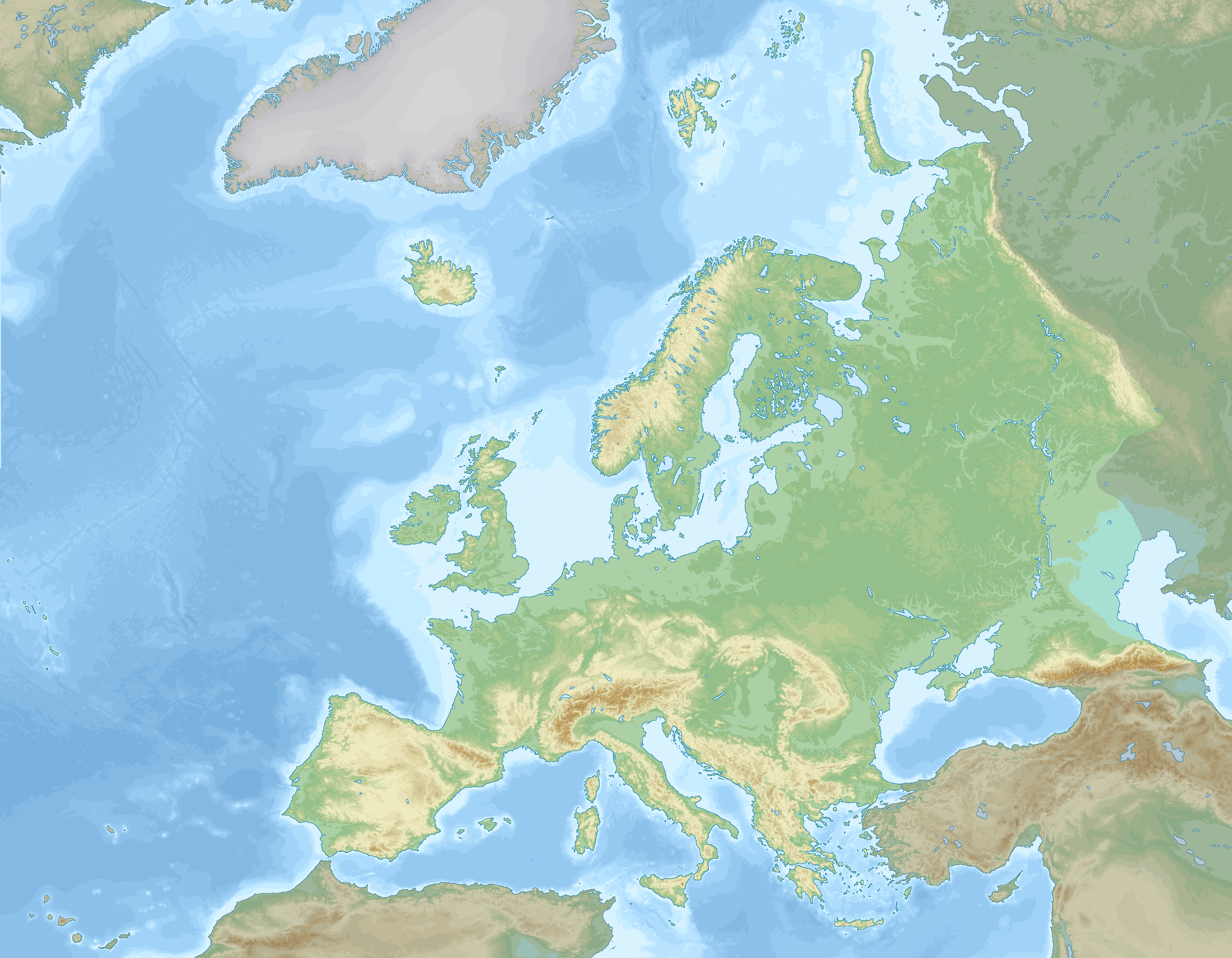
English: Location map of Europe stretching to the Canary Islands, Azores, Franz Joseph land and the entire Caucasus. A definition of Europe as bounded by the Caucasus mountains, Ural river and Ural mountains is shown.
negative
0 to 100 m
100 to 200 m
200 to 300 m
300 to 400 m
400 to 500 m
500 to 600 m
600 to 800 m
800 to 1000 m
1000 to 1200 m
1200 to 1600 m
1600 to 2000 m
2000 to 2500 m
2500 to 3000 m
3000 to 3500 m
3500 to 4000 m
above 4000 m
0 to 100 m
100 to 200 m
200 to 500 m
500 to 1000 m
1000 to 2000 m
2000 to 3000 m
3000 to 4000 m
4000 to 5000 m
below 5000 m
Data source: GEBCO 2022
Elevations (in Europe):
Sea depths:
Map Info
| Projection: | Stereographic |
|---|---|
| Projection center: | North Pole |
| Vertical meridian: | 15.000° E |
| Position of vertical meridian: | 55.4113 % of image width from left edge |
| Position of pole: | 8.9207 % of image height above top edge |
| Scale at pole: | 1.8011 % of image height ( = 1.4013 % of image width) per degree |
| x (%)= | 55.4113 + 160.5827*tan(pi*(90 - $1)/360)*sin(pi*($2 - 15)/180)
|
|---|---|
| y (%)= | -8.9207 + 206.3877*tan(pi*(90 - $1)/360)*cos(pi*($2 - 15)/180)
|
| $1: | latitude in degrees (positive for all locations on map). |
| $2: | longitude in degrees (positive or negative). |
| x (%): | x coordinate expressed as percentage of image width (measured from left edge). |
| y (%): | y coordinate expressed as percentage of image height (measured from top edge). |
ସତ୍ଵ
ମୁଁ, ଏହି କାମର ସତ୍ଵାଧିକାରୀ, ଏଠାରେ ତଳଲିଖିତ ଲାଇସେନ୍ସ ଅଧୀନରେ ଏହାକୁ ପ୍ରକାଶ କଲି:
This file is licensed under the Creative Commons Attribution-Share Alike 4.0 International license.
- ଆପଣ ଆରାମରେ:
- ବାଣ୍ଟିପାରିବେ – କାମଟିକୁ ନକଲ କରିପାରିବେ, ବାଣ୍ଟିପାରିବେ ଓ ପ୍ରସାରଣ କରିପାରିବେ
- ମିଶାଇପାରିବେ – କାମଟି ଅଭିଯୋଜନ କରିପାରିବେ
- ତଳଲିଖିତ ସର୍ତ୍ତାବଳୀ ଅଧୀନରେ:
- ଶ୍ରେୟ – ଆପଣ ମନେ କରି ଏହି କାମର ଆବଶ୍ୟକୀୟ ଶ୍ରେୟ ମୂଳ ଗଢ଼ାଳି ବା ସ୍ୱତ୍ୱାଧୀକାରୀଙ୍କୁ ଦେବେ ଏବଂ ଦେଲାବେଳେ ଲାଇସେନ୍ସର ଲିଙ୍କ ଦେଇ କି କି ବଦଳ କଲେ ଉଲ୍ଲେଖ କରିବେ । ଏହା ଉପଯୁକ୍ତ ଢଙ୍ଗରେ କରିବେ କିନ୍ତୁ ଲାଇସେନ୍ସ ଦେଉଥିବା ବ୍ୟକ୍ତି ଆପଣଙ୍କ ପ୍ରଚାର କଲା ଭଳି କିଛି ଲେଖିବେ ନାହିଁ ।
- ସେଆର ଏଲାଇକ – ଯଦି ଆପଣ ଏହି କାମଟିକୁ ବଦଳାଇବେ, ରୂପାନ୍ତରଣ କରିବେ ବା ଏହାକୁ ନେଇ କିଛି ଗଢ଼ିବେ ତେବେ ଆପଣ ଏହାକୁ ଏକା ବା ଅଲଗା ଲାଇସେନ୍ସ ଭିତରେ ରଖିପାରିବେ ।
Captions
Add a one-line explanation of what this file represents
creator ଇଂରାଜୀ
some value
copyright status ଇଂରାଜୀ
copyrighted ଇଂରାଜୀ
source of file ଇଂରାଜୀ
୧ ଡିସେମ୍ବର 2022
media type ଇଂରାଜୀ
image/png
ଫାଇଲ ଇତିହାସ
ଏହା ଫାଇଲଟି ସେତେବେଳେ ଯେମିତି ଦିଶୁଥିଲା ତାହା ଦେଖିବା ପାଇଁ ତାରିଖ/ବେଳା ଉପରେ କ୍ଲିକ କରନ୍ତୁ
| ତାରିଖ/ବେଳ | ନଖ ଦେଖଣା | ଆକାର | ବ୍ୟବହାରକାରୀ | ମତାମତ | |
|---|---|---|---|---|---|
| ଏବେକାର | ୦୧:୩୩, ୬ ସେପ୍ଟେମ୍ବର ୨୦୨୩ | | ୨,୩୩୪ × ୧,୮୧୬ (୧.୧୯ MB) | GrandEscogriffe | darker non-european lands; coastlines in blue |
| ୦୦:୦୨, ୨ ଡିସେମ୍ବର ୨୦୨୨ |  | ୨,୩୩୪ × ୧,୮୧୬ (୧.୧୭ MB) | GrandEscogriffe | Uploaded own work with UploadWizard |
ଫାଇଲ ବ୍ୟବହାର
ଏହି ଫାଇଲ ସହିତ ଯୋଡ଼ା ଗୋଟିଏ ବି ପୃଷ୍ଠା ନାହିଁ ।
ଜଗତ ଫାଇଲ ବ୍ୟବହାର
ତଳଲିଖିତ ଉଇକିସବୁ ଏହି ଫାଇଲଟିକୁ ବ୍ୟବହାର କରିଥାନ୍ତି:
- en.wikipedia.orgରେ ବ୍ୟବହାର
- fr.wikipedia.orgରେ ବ୍ୟବହାର
- Mer de Barents
- Mer Égée
- Dardanelles
- Nouvelle-Zemble
- Île Jan Mayen
- Rockall
- Île aux Ours
- Mer de Kara
- Liste des départements de France par altitude
- Mer Blanche
- Kolbeinsey
- Mer de Norvège
- Mer du Groenland
- Terre François-Joseph
- An Tiaracht
- Gavdos
- Cabo da Roca
- Détroit de Danemark
- Liste des provinces et territoires d'outre-mer des Pays-Bas par point culminant
- Canal de Sicile
- Capelinhos
- Cap Fligely
- Mer d'Irminger
- Baie Baïdaratskaïa
- Liste des régions et provinces d'Italie par altitude
- Mer Caspienne
- Svalbard
- Liste des cantons de Suisse par altitude
- Cap Jelania
- Bjargtangar
- Rossøya
- Mer de Sicile
- Pointe de Tarifa
- Île Victoria (Russie)
- Cap Flissingski
- Îlot de Monchique
- Vatnahverfi
- Fosse Calypso
- Liste des comtés d'Irlande par point culminant
- Liste des Länder d'Allemagne par point culminant
- Modèle:Palette Liste des points culminants des pays d'Europe
- Liste des entités de Belgique par point culminant
- Modèle:Géolocalisation/Europe 2
- Wikipédia:Atelier graphique/Cartes/Archives/décembre 2022
- Liste des provinces d'Espagne par point culminant
- Liste des fylker de Norvège par point culminant
- Liste des Länder d'Autriche par point culminant
- Liste des régions de Finlande par point culminant
ଏହି ଫାଇଲଟିର ଅଧିକ ବିଶ୍ୱବ୍ୟାପୀ ବ୍ୟବହାର ଦେଖନ୍ତୁ ।