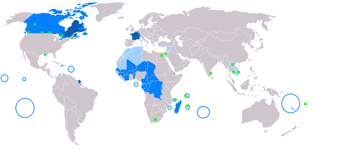
File:Map-Francophone_World.png
From Wikipedia, the free encyclopedia
Talha d'aquesta previsualizacion: 800 × 354 pixèls. Autras resolucions : 320 × 142 pixèls | 640 × 283 pixèls | 1 425 × 631 pixèls.
Fichièr d'origina (1 425 × 631 pixèl, talha del fichièr: 39 Ko, tipe MIME: image/png)
| Aqueste fichièr proven de Wikimedia Commons?. Las informacions que lo concernisson son afichadas çaijós (procedura). |
Descripcion
| DescripcionMap-Francophone World.png |
English: Map of Francophone world.
Français : Carte du monde où on parle le français.
Русский: Карта франкоязычного мира.
Nederlands: Het Frans in de wereld.
Suomi: Maailmankartta ranskaa puhuvista maista.
Українська: Мапа франкомовного світу.
日本語: フランス語圏の地図。
中文:说法语的人在世界上的分布情况
Čeština: Mapa frankofonního světa
|
| Llegenda InfoField | English:
Français :
Español:
Deutsch:
Русский:
العربية:
Slovenčina:
Čeština:
Esperanto:
Italiano:
Magyar:
Nederlands:
Norsk bokmål:
Polski:
Português:
Română:
Suomi:
Svenska:
Türkçe:
Українська:
中文:
日本語: |
| Data | |
| Font |
Incomplete Ce fichier est dérivé de : BlankMap-World.png: |
| Autor |
|
Publicat jos licéncia(s)
| Public domainPublic domainfalsefalse |
| S'ha alliberat aquesta obra al domini públic pel seu autor Yug. Això s'aplica a tot el món. En alguns països això pot no ser legalment possible, en tal cas: |
Llegendes
Afegeix una explicació d'una línia del que representa aquest fitxer
Elements representats en aquest fitxer
subjècte representat
10 decembre 2005
tipus de mèdia d'Internet catalan
image/png
Istoric del fichièr
Clicar sus una data e una ora per veire lo fichièr tal coma èra a aqueste moment
(Darrièras contribucions | Primièras contribucions) Veire (10 mai recentas) (10 mai ancianas) (10 | 20 | 50 | 100 | 250 | 500).
| Data e ora | Miniatura | Dimensions | Utilizaire | Comentari | |
|---|---|---|---|---|---|
| actual | 9 març de 2018 a 20.20 | | 1 425×631 (39 Ko) | Maphobbyist | South Sudan border |
| 23 genièr de 2018 a 12.30 |  | 1 425×631 (39 Ko) | Maphobbyist | Sticking to sources. French is not the majority mother language in Gabon and Ivory coast and in its capital cities. | |
| 19 abril de 2017 a 13.22 |  | 1 425×631 (39 Ko) | Sorkiv | The French language has become native to Gabon and Côte d'Ivoire (Abidjan, Yamoussoukro). | |
| 7 mai de 2015 a 12.53 |  | 1 425×631 (39 Ko) | Zorion | From Hearst (Ontario) to Abitibi, it's a french-speaking zone + Anticosti added + remouved a part of New-Brunswick + francophone in Alberta are located in the Noth-West + Aroostook County in US | |
| 11 decembre de 2014 a 17.52 |  | 1 425×631 (56 Ko) | Maphobbyist | In Syria French is a secondary non-official language. | |
| 11 decembre de 2014 a 16.57 |  | 1 425×631 (49 Ko) | Maphobbyist | In New Caledonia, French is the sole official language, but it is the mother language of a minority. | |
| 6 març de 2008 a 17.13 |  | 1 425×631 (32 Ko) | Arctic.gnome | French is administrative in Canada and a secondary language in Andorra. I also added PEI and Manitoulin Island to Canada, and Saint Pierre, Miquelon and Sable islands around the Newfoundland coast. | |
| 6 març de 2008 a 17.09 |  | 1 425×631 (50 Ko) | Arctic.gnome | Reverted to version as of 20:37, 22 January 2007 | |
| 6 març de 2008 a 17.08 |  | 1 425×631 (32 Ko) | Arctic.gnome | == Summary == Map of Francophone world. Map made from Image:BlankMap-World.png '''English''' legends: {{legend|#0c5eb1|native language}} {{legend|#0080ff|administrative language}} {{legend|#9fceff|secondary or non-official langua | |
| 22 genièr de 2007 a 20.37 |  | 1 425×631 (50 Ko) | IAMTHEEGGMAN | Updating actual World Map and Adding Montenegro. |
(Darrièras contribucions | Primièras contribucions) Veire (10 mai recentas) (10 mai ancianas) (10 | 20 | 50 | 100 | 250 | 500).
Paginas que contenon lo fichièr
I a ges de pagina que compòrta un ligam vèrs aqueste imatge.
Usatge global del fichièr
Los autres wikis seguents utilizan aqueste imatge :
- Utilizacion sus de.wikipedia.org
- Utilizacion sus en.wikipedia.org
- Utilizacion sus fr.wikipedia.org
- Utilizacion sus fr.wiktionary.org
- Utilizacion sus he.wikivoyage.org
- Utilizacion sus it.wikipedia.org
- Utilizacion sus it.wiktionary.org
- Utilizacion sus no.wiktionary.org
- Utilizacion sus zh-min-nan.wikipedia.org
Metadonadas
Aqueste fichièr conten d'entresenhas suplementàrias probablament apondudas per l’aparelh de fòto numeric o l'escanèr que las a aquesas. Se lo fichièr es estat modificat dempuèi son estat original, d'unes detalhs pòdon reflectir pas entièrament l’imatge modificat.
| Resolucion orizontala | 37,8 ppc |
|---|---|
| Resolucion verticala | 37,8 ppc |
Recuperada de « https://oc.wikipedia.org/wiki/Fichièr:Map-Francophone_World.png »