File:Cz-svk_granica.png
From Wikipedia, the free encyclopedia
Pas de resolucion mai nauta de disponibla.
Cz-svk_granica.png (577 × 366 pixèl, talha del fichièr: 31 Ko, tipe MIME: image/png)
| Aqueste fichièr proven de Wikimedia Commons?. Las informacions que lo concernisson son afichadas çaijós (procedura). |
| DescripcionCz-svk granica.png |
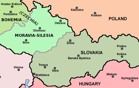
English: Map of Czech-Slovakia border |
| Data | (UTC) |
| Font | |
| Autor |
|
| Això és una imatge retocada, cosa que vol dir que ha estat alterada digitalment de la seva versió original. Modificacions: piece of file. L'original es pot veure a: Czechoslovakia01.png:
|
Ieu, autor d'aquesta òbra, publiqui jos la licéncia seguenta:
| Public domainPublic domainfalsefalse |
| Jo, el titular del copyright d'aquesta obra, l'allibero al domini públic. Això s'aplica a tot el món. En alguns països això pot no ser legalment possible, en tal cas: Jo faig concessió a tothom del dret d'usar aquesta obra per a qualsevol propòsit, sense cap condició llevat d'aquelles requerides per la llei. |
Registre original de càrregues
This image is a derivative work of the following images:
- File:Czechoslovakia01.png licensed with PD-self
- 2011-04-24T10:38:30Z PANONIAN 1128x513 (63994 Bytes) few corrections
- 2011-04-23T11:31:49Z PANONIAN 1128x509 (62348 Bytes) improved version
- 2008-12-20T20:58:14Z Kirk 1100x497 (80038 Bytes) {{Information |Description= |Source= |Date= |Author= |Permission= |other_versions= }}
- 2006-12-28T16:11:35Z Electionworld 1100x497 (92110 Bytes) {{ew|en|PANONIAN}} Map of {{link|Czechoslovakia}} (self made) Note: The provinces shown on the map were introduced by Act No. 125/1927 Zb. and became effective in 1928. {{PD-self}} [[Category:Maps of Czechoslovakia]] [[Cat
Téléversé avec derivativeFX
Llegendes
Afegeix una explicació d'una línia del que representa aquest fitxer
Elements representats en aquest fitxer
subjècte representat
25 abril 2011
tipus de mèdia d'Internet catalan
image/png
suma de verificació catalan
07afaaed2827aa098bfdfe0f97b9d6bd5ad92abc
mida de les dades catalan
31 517 Byte
366 píxel
amplada catalan
577 píxel
Istoric del fichièr
Clicar sus una data e una ora per veire lo fichièr tal coma èra a aqueste moment
| Data e ora | Miniatura | Dimensions | Utilizaire | Comentari | |
|---|---|---|---|---|---|
| actual | 12 agost de 2011 a 17.26 | | 577×366 (31 Ko) | Millenium187 | There was a quite significant flaw, today's Czech republic consists of three historical countries: Bohemia, Moravia and Czech Silesia, each of them has its own coat of arms, flag, history, etc. Moravia is not in Bohemia, it's like to say that Scotland is |
| 25 abril de 2011 a 09.19 |  | 577×366 (22 Ko) | Mixx321 | dr | |
| 25 abril de 2011 a 09.17 |  | 577×366 (23 Ko) | Mixx321 | {{Information |Description=* '''English:''' Map of Czech-Slovakia border |Source=*File:Czechoslovakia01.png |Date=2011-04-25 09:15 (UTC) |Author=*File:Czechoslovakia01.png: Electionworld *derivative work: ~~~ |Permission |
Paginas que contenon lo fichièr
I a ges de pagina que compòrta un ligam vèrs aqueste imatge.
Usatge global del fichièr
Los autres wikis seguents utilizan aqueste imatge :
- Utilizacion sus pl.wikipedia.org
Recuperada de « https://oc.wikipedia.org/wiki/Fichièr:Cz-svk_granica.png »