File:Westbankjan06-samaria.jpg
From Wikipedia, the free encyclopedia
Opprinnelig fil (1 434 × 814 piksler, filstørrelse: 210 KB, MIME-type: image/jpeg)
| Denne filen er fra Wikimedia Commons og kan brukes av andre prosjekter. Informasjonen fra filbeskrivelsessiden vises nedenfor. |
Beskrivelse

|
Dette bildet bør gjenskapes med hjelp av vektorgrafikk som en SVG-fil. Dette har flere fordeler, se Commons:Media for cleanup for mer informasjon. Hvis en SVG-fil med dette bildet er tilgjengelig, vennligst last den opp. Etter opplasting erstatt denne malen med {{vector version available|nytt bilde.svg}}.
|
 | This ethnographic map image was uploaded in the JPEG format even though it consists of non-photographic data. This information could be stored more efficiently or accurately in the PNG or SVG format. If possible, please upload a PNG or SVG version of this image without compression artifacts, derived from a non-JPEG source (or with existing artifacts removed). After doing so, please tag the JPEG version with {{Superseded|NewImage.ext}} and remove this tag. This tag should not be applied to photographs or scans. If this image is a diagram or other image suitable for vectorisation, please tag this image with {{Convert to SVG}} instead of {{BadJPEG}}. If not suitable for vectorisation, use {{Convert to PNG}}. For more information, see {{BadJPEG}}. |  |
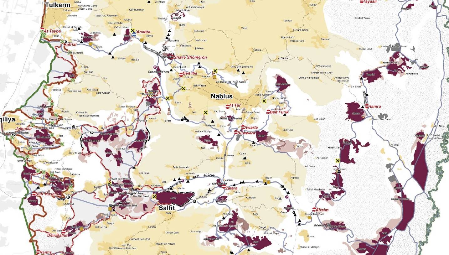
Right-click the map legend (below right) to open it in a separate browser tab or window. Then click the image there to enlarge it.
|
 |
Lisensiering
| Public domainPublic domainfalsefalse |
| This image is a map derived from a United Nations map.
Unless stated otherwise, UN maps are to be considered in the public domain. This applies worldwide. UN maps are, in principle, open source material and you can use them in your work or for making your own map. UN requests however that you delete the UN name, logo and reference number upon any modification to the map. Content of your map will be your responsibility. You can state in your publication, if you wish, something like: based on UN map … (map name, map number, revision number and date). See: Geospatial Information Section. And: Geospatial, location data for a better world. |
 |
Orginal opplastningslogg
- 2007-08-18 12:03 JWB 1434×814× (214554 bytes) Piece of [:[Image:Westbankjan06.jpg]]
Bildetekster
Elementer som er med i denne fila
motiv
18. aug. 2007
Filhistorikk
Klikk på et tidspunkt for å vise filen slik den var på det tidspunktet.
| Dato/klokkeslett | Miniatyrbilde | Dimensjoner | Bruker | Kommentar | |
|---|---|---|---|---|---|
| nåværende | 31. mar. 2009 kl. 16:27 | | 1 434 × 814 (210 KB) | File Upload Bot (Magnus Manske) | {{BotMoveToCommons|en.wikipedia|year={{subst:CURRENTYEAR}}|month={{subst:CURRENTMONTHNAME}}|day={{subst:CURRENTDAY}}}} {{Information |Description={{en|Piece of en::Image:Westbankjan06.jpg which is a detailed map of Israeli settlements on the [[:en:W |
Filbruk
Det er ingen sider som bruker denne filen.
Global filbruk
Følgende andre wikier bruker denne filen:
- Bruk i cs.wikipedia.org
- Bruk i en.wikipedia.org
Metadata
Denne filen inneholder tilleggsinformasjon, sannsynligvis lagt til av digitalkameraet eller skanneren som ble brukt til å lage eller digitalisere det.
Hvis filen har blitt forandret fra utgangspunktet, kan enkelte detaljer være unøyaktige.
| Horisontal oppløsning | 96 dpi |
|---|---|
| Vertikal oppløsning | 96 dpi |
| Programvare brukt | Paint.NET v3.0 |